休斯顿纪念公园总体规划 | 生态弹性、历史解读与景观重塑
来自
ASLA
Memorial Park Master Plan 2015 by
Nelson Byrd Woltz Landscape Architects
.更多请至:
Appreciation towards
ASLA
for providing the following description:
项目陈述 PROJECT STATEMENT
21世纪的纪念公园总体规划方案
休斯顿纪念公园空间被道路与散布在敏感自然保护区中的休闲活动空间切割得支离破碎,导致了公园生态系统的退化与空间质量的大幅下降。而飓风与连年的干旱更是让曾经遮天蔽日的绿意不复存在。这片占地1460英亩的公园深受人们喜爱,而这种突如其来的巨大变化自然引起了群众的呼声,也引发了人们对公园未来的思考,改造规划迫在眉睫。公园被视作休斯顿中央城区最宝贵的生态资源,一片让人们能够暂时逃离城市喧嚣,放松身心,亲近、学习自然的土地。
来自Nelson Byrd Woltz 景观事务所的设计师与业主、利益相关者和顾问团队合作,开始着手于一个雄心勃勃,跨越两年的规划设计。而在此之前,时长18个月的公众参与、历经一年的生态取证与严谨的调研则为设计逻辑提供了强而有力的支持,在第一阶段设计施工中引导着方案的实践与进行。设计团队将生态弹性、基地历史的演绎与破碎空间的重新联系视作设计的重点,为市民创造了一个生机勃勃、活力十足的公园空间。
Memorial Park in the 21st Century – A Master Plan
Houston’s Memorial Park has been fragmented by roads and by the placement of recreational program in sensitive wilderness areas, leading to ecological degradation and diminished quality of spaces. Recent hurricanes and years of extreme drought have devastated the park manifesting widespread canopy loss. This major and sudden change in the character of this beloved 1,460-acre park has led to public outcry and demand for a call to action, providing the opportunity to reimagine its future. The park is envisioned to become central Houston’s most valuable ecological resource that will serve as a place for retreat, recreation, and learning.
The landscape architect in partnership the client, stakeholders, and a team of consultants embarked on an ambitious two-year planning process. An 18 month-long public input process and a year of ecological forensics and rigorous research revealed a design logic that informed the master plan. This approach continues to inform the design as the first phase of implementation has commenced. The vision prioritizes ecological resilience, interpretation of the site’s historical narratives, and the reconnection of disjointed spaces to create a healthy and vibrant park.
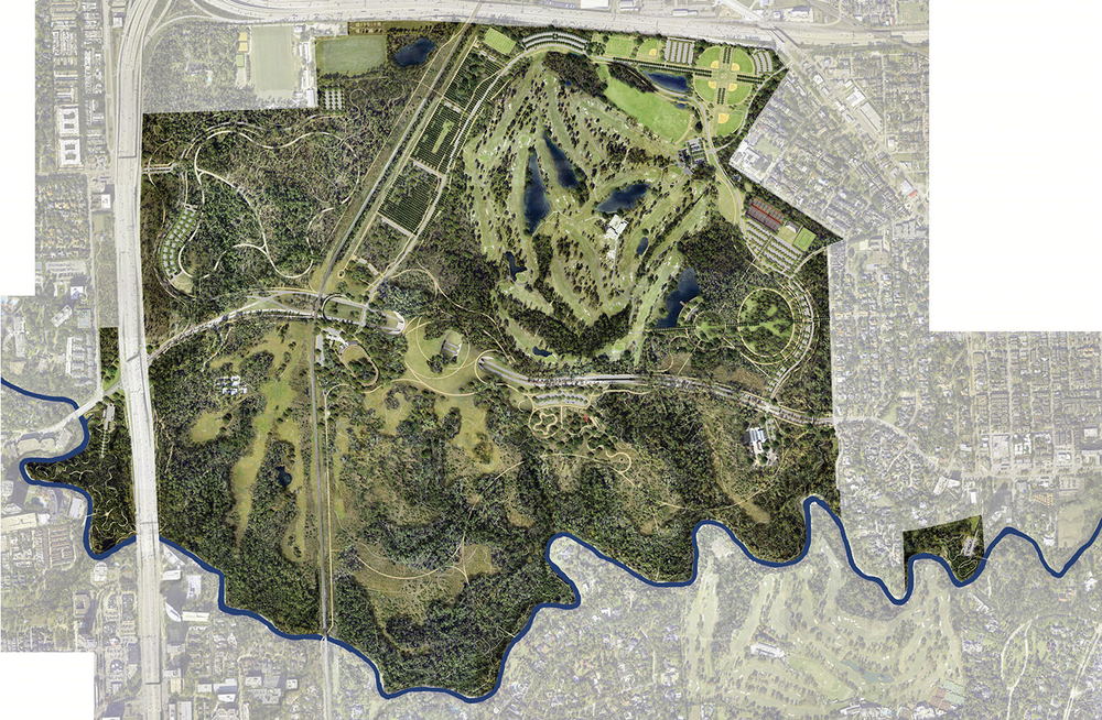
△ 纪念公园总平面图
Master plan for Memorial Park.
Photo Credit: Nelson Byrd Woltz Landscape Architects
项目说明 PROJECT NARRATIVE
休斯顿纪念公园设计
纪念公园位于610环路内侧,南侧以布法罗河为界,向东距离休斯顿中心城区不过4英里,因此也深受市民的喜爱。作为曾经的一战士兵训练营,这个位于全美第四大城市之内,占地达1500英亩的公园身上有着悠久而错综复杂的历史。公园始建于1924年以纪念在欧洲战场牺牲的战士。然而,经过了人们百余年的精心照料,无论是在生态还是文化方面,这里都积累下了更为深厚的沉淀。
不幸的是,近年来的持续干旱与飓风侵扰让公园内延绵的松林不复存在,这也引发了将其视若珍宝的休斯顿群众的强烈抗议。休斯敦市政府、上城发展管理部门以及纪念公园管理部门联手开启了总体规划章程,重新评估公园长期发展的规划策略,并应对近百年来城市扩张在文化脉络与生态系统方面带来的挑战。
其实,休斯顿人民所钟爱的茂盛松林对于生态系统来说并不具备可持续性,其更多只是管理上的拖延与适度放任带来的副产品。建立在对场地原生生态完整理解的基础上,景观设计团队决定以足以抵御未来水旱灾害,多样化的景观类型取代树种单一的林地,重塑数百年前人类尚未入侵时的生态环境。而作为总体规划章程的一部分,大量而全面的相关研究相继开展,让设计团队得以从历史和当代两种不同的语境中理解公园的生态与地质情况。而研究也证明了这片在过去的70年中占据了纪念公园大片场地,繁衍生息的松林并非本土树种。而下层植被更是大多由入侵物种群落组成,在部分区域入侵物种比例甚至高达99%。
设计团队将公园空间分为了三种类型-一部分空间将通过具体的实施和管理策略达到生态多样性,一部分空间则需要维持与保护,而新建或从敏感地带迁出的活动空间则以更紧凑的格局点缀在公园之中。科学数据及文献资料显示,在过去的数百年间南侧公园中人类文明与自然的占领空间此消彼长,相互影响而尚未达到稳定状态,这也意味着此地重新建立野生动物通行廊道与生态多样性的潜力极大。布法罗河蜿蜒曲折,画出了公园的南侧边界,也带来了浑然天成的生态空间层次。从河流空间向外侧依次为河岸阔叶林,针、阔叶混合林带,针 – 阔叶疏林草地与开阔的草原。这片延绵20余英里,通过木栈道与小径让人们得以深入接触海湾沿岸草原生态系统的区域被称为河湾野生保护区。
每年,公园都会消耗8千5百万加仑的饮用水以供灌溉。而随着战略性蓄水措施的成功建立,从暴雨中储存下的雨水每年可节约近6千万加仑的水源消耗。而这些蓄水池同时也将成为水生动植物栖息地,进一步强化公园的生态多样性,同时也为游人带来更舒适的空间与环境。景观团队与土木工程师合作,对公园内的自然与人造水文进行了详尽的调查,绘制出园区与流域内的水系格局。
而除了重塑生态历史、保护野生动植物群落与水源的雄心外,公园的文化历史也见证了城市与其自身百年间的发展历程。而这种种发现一点点影响、塑造了规划方案最终的模样,让被遗忘的历史重归人们的视野。
在19世纪,这片区域曾被用作牧场、林场、果园、苗圃、砖窑和木炭生产厂。而当美国最终在1917年加入到一战中时,美国在全国范围内建立起军事培训基地,而休斯顿这片最终被命名为Logan军营的区域因为其远离城市却靠近铁路,易于传送建造所需材料、后勤物资和士兵而入选,成为了32个培训基地之一。在其服役期间,数以万计的国民警卫队成员在此受训,备战于法国进行的战役。然而今天,只有寥寥无几的混凝土建筑基础仍残留在公园之内,而公园建立之本的纪念意义似乎也渐渐消散。在新方案中,四种本土针叶树种如同集结的步兵官兵般井然有序地列植在近65英亩的场地中,成为了致敬一战烈士的鲜活纪念碑,而穿插其中的是已经在公园中生长多年的针叶与阔叶树种。
在公园的东侧另一片场地的设计同样根植于其文化历史。在20世纪20年代 Hare和Hare事务所的纪念公园设计中有一片“公园”区域,圆形小路环绕着一个也许会用作温室的小小建筑。这启发了设计师对The Glades地区的设计,高大的树木松散地种植在草地上,池塘则位于草地的一旁,同心椭圆小路在不同的植被间穿行,形成林地漫步道。对文化景观的全面研究让这片如今被称作Eastern Glades唤醒了人们对Hare和Hare“公园”设计的回忆,同时也呼应着原有从Blossom大街进入Logan军营时将经过的大门空间。
从纪念公园成立至今的百余年间,一条条高速与城市道路相继建成,将休闲区和动植物生态栖息地切割得支离破碎,同时也威胁着公众的安全。受到大型野生动物迁徙的启发,景观设计团队许下雄心,决意建立两座路桥,以重新连接公园的南北两个部分。开阔的桥面上覆以草地,灌木与树丛点缀其上,休斯顿的人们顺着小道,在自然中穿行。
纪念公园的总体规划实现了当前城市对娱乐休闲的需求,同时也保护了休斯顿居民所珍视的城市自然的品质。整合相似相融的公园项目不仅可以增强园区使用者的使用体验,而且可以大幅度的降低使用者之间的冲突。此外,这种融合可以更好的利用园内设施和园内交通,提高安全性,人们可以通过辨别出入口来辨别方向。独特又合理的路径可以带领游客游览并了解公园。地区之间的连接可以增加公园的使用率并提高步行,轮椅,自行车,汽车及公交车的出入安全。
按总体规划方案实施的纪念公园将成为一个拥有多样化的本地生态环境,联系古今的弹性公园。不同的利益相关者都参与到设计中,而最终的规划方案将对纪念公园未来的改造起到指导的作用。第一阶段的建设将于2016年秋季开始。
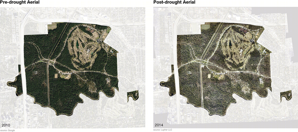
△ 在20世纪,火炬松林是公园生态系统的主要组成部分。然而,这个深受游客喜爱的松林却最终被证明并非生态可持续的。到2011年,长期的干旱和干旱带来的飓风导致公园内的树木死亡率大幅增高。
During the 20th century loblolly pines came to dominate much of the park ecology. Beloved by visitors, this pine forest was ultimately unsustainable. A protracted draught and subsequent hurricanes led to widespread tree mortality throughout the park by 2011.
Photo Credit: Nelson Byrd Woltz Landscape Architects

△ 来自1983年Marguerite Key Fitzgerald生态研究的黑白照片展示了疏林草地组成的开放空间与本地区原生、由针叶或阔叶树木和开阔草地组成的生态环境类似。与右下角的彩色图片中茂密的下层植被截然不同。
This photo from the 1938 ecological study by Marguerite Key Fitzgerald shows open areas of grass and loose motts of trees similar to pine, hardwood savannah, a native regional ecology. Contrast with inset of thicketized understory.
Photo Credit: Nelson Byrd Woltz Landscape Architects
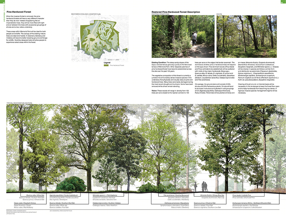
△ 剖面图表现了针阔叶混合林的修复方式。建立在对场地原生生态完整理解的基础上,景观设计团队决定以足以抵御未来水旱灾害的多样化景观群落类型重塑数百年前人类尚未入侵时的生态环境。
Section showing proposed restoration of the pine-hardwood forest. Understanding the authentic, native ecologies led to restoration schemes for a matrix of landscape types that could resist drought and flood as they had for hundreds of years prior to European settlement.
Photo Credit: Nelson Byrd Woltz Landscape Architects
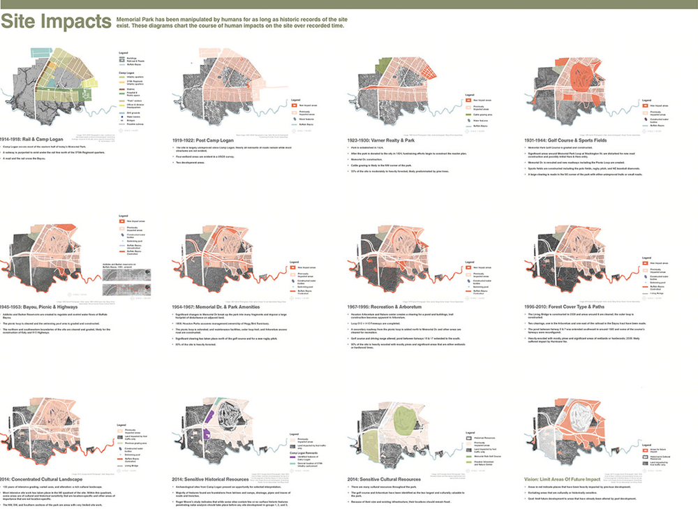
△ 设计团队对于场地历史研究的大致总结,图形化的总结让参与会议的普通公民更容易明白场地的历史。成功的公众参与活动从超过3,000的群众中征求到关于现状环境,所需功能和公园空间格局的意见和建议。
A board summarizing the design team’s site history research, and used to facilitate public engagement meetings. A robust public input process solicited comments from over 3,000 individuals on existing conditions, programming and composition of the park.
Photo Credit: Nelson Byrd Woltz Landscape Architects
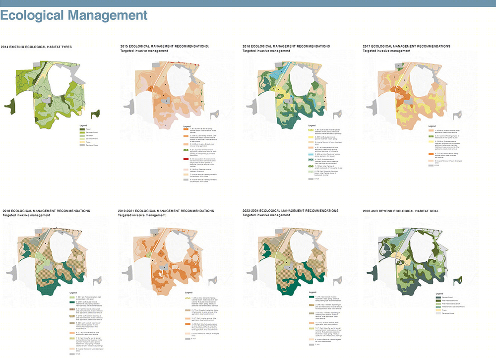
△ 通过设计和管理实现生态保护,这些图表列出了在十年期间通过运用介入式管理和许植策略,将现存单一的茂盛下层植被转化为多样化的本土生态栖息地的过程
Ecological restoration is achieved through both design and management. These diagrams show a ten-year sequence of the transformation from existing habitats of homogeneous thicketized understory to diverse native habitats using invasive management and planting strategies.
Photo Credit: Nelson Byrd Woltz Landscape Architects
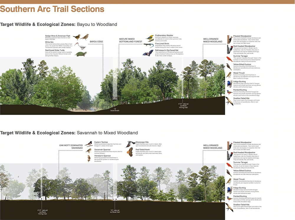
△ 剖面展现了恢复后的生态系统以及在其中生活繁衍的野生动物族群。
The section shows a reintegrated ecology and the fauna species it supports.
Photo Credit: Nelson Byrd Woltz Landscape Architects
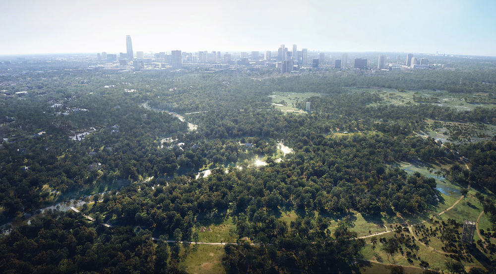
△ 南边的弧形路是公园南侧的主要交通路径,独特的几何形状让其成为了这片荒野地区广阔林地中的重要地标。
The Southern Arc Trail is the major spine throughout the south side of the park, its geometry serving as a significant orienting landmark in the expansive wooded zones of this wilderness area.
Photo Credit
: MIR for NBW
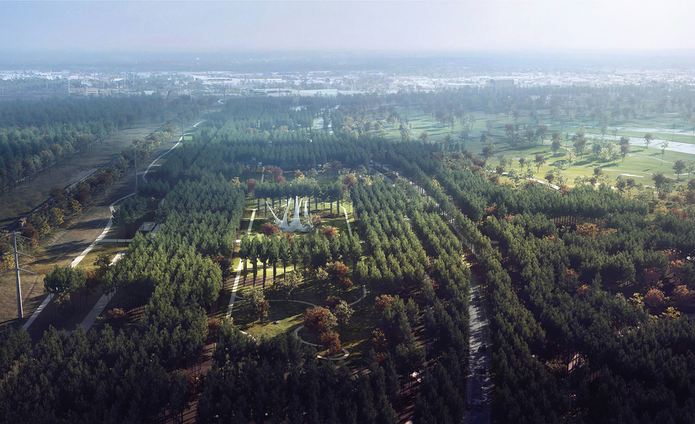
△ 这片位于铁路路轨东侧的场地中散布着大量Logan军营的遗迹。延绵的纪念林地表达了对于来此训练的一战士兵的追忆与致敬。
The areas just east of the railroad track, host the highest number of Camp Logan remnants, the plan proposes a series of Memorial Groves to honor the World War I soldiers who trained on site.
Photo Credit: MIR for NBW
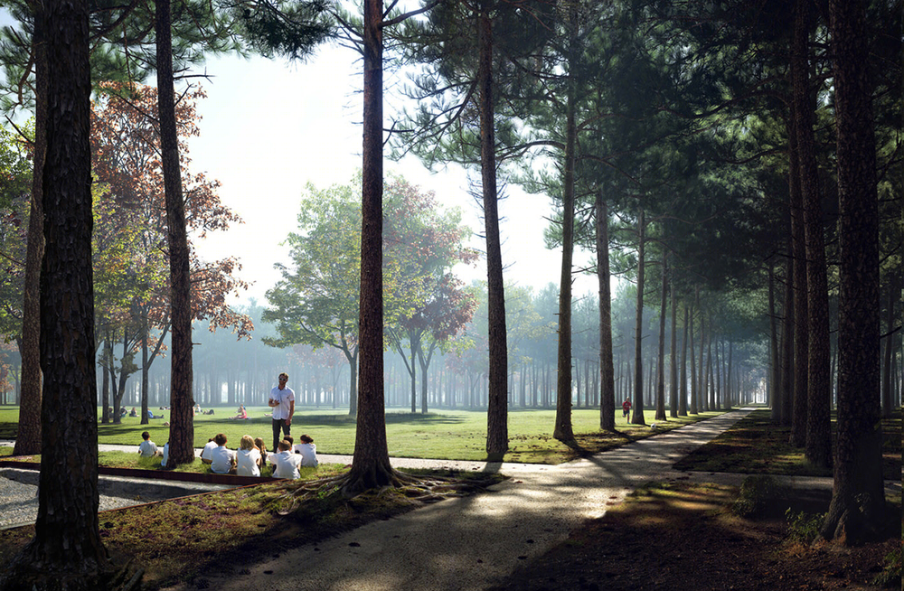
△ 纪念丛林效果图,位于左下角的是一战时期Logan军营的遗迹。列植的混合松树林地让人想起步兵集结时整齐的队列。
Rendering of the proposed Memorial Groves, showing a remnant of the WWI era Camp Logan on the far lower left. The grid of the mixed pines recall the regimental formations of soldiers.
Photo Credit: MIR for NBW
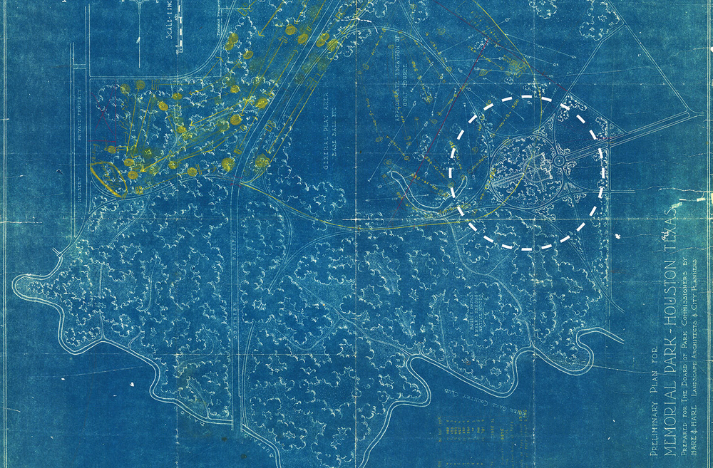
△ 1920年代 Hare和Hare设计的公园区域内有一个中央建筑和环形道路。这启发了设计师对The Glades地区的设计,高大的树木松散地种植在草地上,池塘则位于草地的一旁,同心椭圆小路在不同的植被间穿行,形成林地漫步道。
The 1920’s Hare and Hare plan revealed the “Garden” area, with a central building and ovoid formal path. This inspired The Glades, an area of high loose canopy, grass, pond, and woodland walks framed by concentric elliptical paths and plantings.
Photo Credit: Houston Metropolitan Research Center
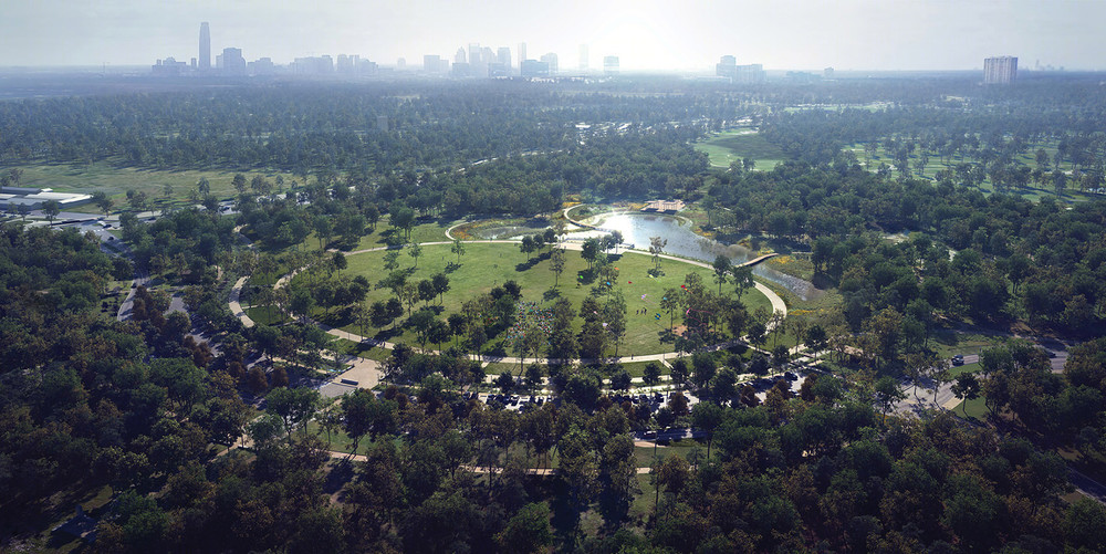
△ The Glades现在正在施工中,在未来,这里将会形成两个大型开放空间。留存下来的针叶、阔叶树创造了安静的林下空间,用于野餐或其它较为安静的活动。而环绕四周的原生态漫步道可以给人们提供舒适的漫步景观体验。
The Glades, currently under construction, are envisioned as two large open spaces with existing pines and hardwoods preserved to create shady and quiet space for picnicking and passive uses. Wide promenades around these spaces allow for pleasure walking and orientation.
Photo Credit: MIR for NBW

△ 位于仍在设计中的Land Bridge西南侧的跑步中心是园区内一个主要的功能聚集区,其入口位于公园西侧,纵横的小路将跑步中心与公园的其他部分连接起来。
The Running Center is a major programmatic hub and access point on the western side of the park. Nestled into the southwestern arm of the proposed Land Bridge, trails connect the running center to the rest of the park.
Photo Credit: Hartness Vision for NBW
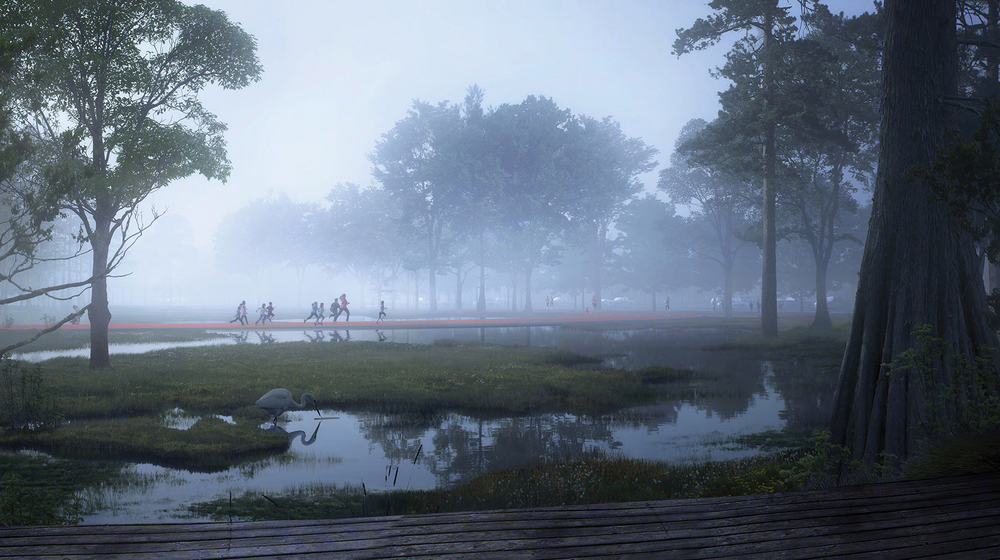
△在未来,位于跑步中心的最南边、带有室外座椅的雨水滞留区将作为生态栖息地和游人关注的焦点而存在。跑步者可以在跑道的南端横穿湿地区域。
At the southern end of the Running Center, a stormwater detention area with wetland benches will serve as habitat and focal points for long views. Runners will cross its neck at the southern end of the track.
Photo Credit: MIR for NBW
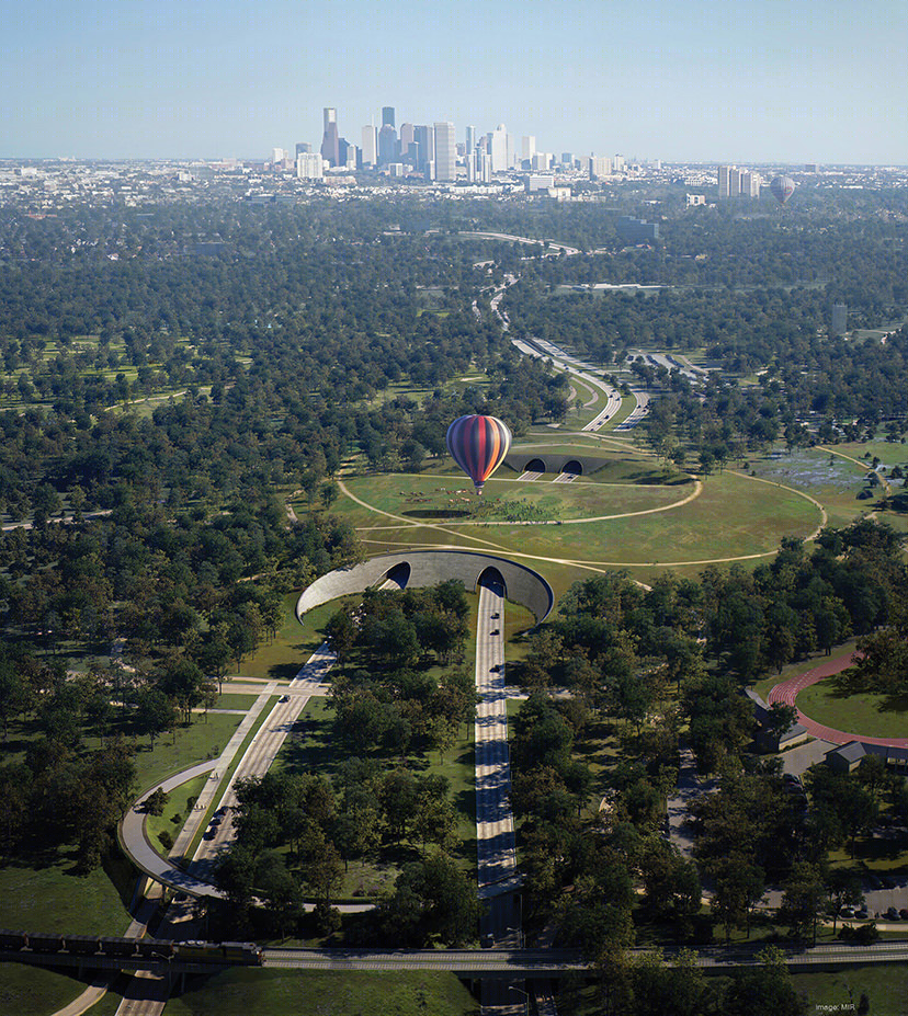
△
纪念大道上Land Bridge效果图。这片绿色基础设施重新连接了公园的南北两边,为人们和野生动物提供了安全的穿行道路。
Artist’s visualization of the Land Bridge over Memorial Drive. This piece of green infrastructure reconnects the northern and southern halves of the park for people and wildlife.
Photo Credit: MIR for NBW
Memorial Park Master Plan Houston
Memorial Park lies within the 610 Loop, adjacent to Buffalo Bayou, four miles to the west of Downtown Houston and at the heart of many Houstonians. At nearly 1,500 acres of parkland in the fourth most populous city in the United States, this former training camp for WWI soldiers is full of rich histories and complicated relationships. Established in 1924 as a memorial to the soldiers who died fighting in the European theater, this landscape and the people who have tended and nurtured it for almost a century have much to reveal about its ecological and cultural origins.
Recent and extended droughts and a significant hurricane decimated the existing pine-dominant canopy of the park. The loss of the trees cherished by so many Houstonians created a massive public outcry. Three entities – the City of Houston, the Uptown Development Authority and the Memorial Park Conservancy – initiated a master plan process to reevaluate the long term planning strategy for the park and to assess the challenges created by a century of urban expansion on the cultural imprint and ecological systems contained within.
The dense forests that Houstonians grew to love were not necessarily sustainable in this landscape but were a byproduct of decades of deferred maintenance and benign neglect. Understanding the authentic, native ecologies of the site led to ideas of restoration not of one type of forest but rather a matrix of landscape types that could resist drought and flood into the future, just as they had done for hundreds of years prior to European settlement. As part of the master plan process extensive studies were performed to understand the ecology and geology of the park in both a deep historical and contemporary context. Research revealed that the ecotype—a pine-dominant forest—that has thrived at Memorial Park over the past 70 years is not endemic to the site. The thicketized understory is comprised of invasive species, in some places up to 99 percent.
The proposed design targets areas for increasingly diverse ecologies through implementation and management strategies, areas for conservation efforts, and the concentration of new and relocated programming in the most disturbed areas. This scientific and cultural data revealed that the greatest potential for wildlife connectivity and biodiversity lay in the southern half of the park where the interplay between cultural and ecological manipulation had persisted for centuries. With Buffalo Bayou occupying the southern border of the park, a suggested gradation of ecological zones presented itself, projecting from the bayou: riparian hardwood forest, mixed pine and hardwood forest, pine-hardwood savannah and open native grass prairie. The Bayou Wilds is the name proposed for this region of Memorial Park, as it will provide access to these gulf coastal prairie ecologies along 20 miles of boardwalks and hiking trails.
The park uses 85 million gallons of Houston’s drinking water per year for park irrigation. This led to the realization that with strategic impoundment, the designed site could capture enough runoff from storm events to offset 60 million gallons annually. Proposed retention ponds will also increase the biodiversity of aquatic habitats within the park and provide an amenity for park users. In collaboration with civil engineers, the research on the park’s natural and constructed hydrology generated maps of the drainage patterns within the site and the watershed.
In addition to the ecological history of the site and the ambitious goals for conservation of wildlife and water, the cultural history of the site offered a layered repository of traces of the city’s and park’s development over time. Many of these discoveries directly shaped the design proposals for the new master plan as they brought legibility to forgotten histories.
The range of early uses of the site included livestock grazing, logging, orchards, plant nursery, brick kilns, and charcoal production throughout the 19th century. With America’s late entry into World War I in 1917, it was necessary to build military training facilities across the United States. Houston won a contract to build one of the thirty-two training centers. The site of what would become known as Camp Logan, was chosen for lease due to its rural nature and proximity to existing rail lines that provided easy transportation of construction materials, supplies, and soldiers. During the camp’s existence, tens of thousands of National Guard soldiers trained for campaigns in France. Only concrete building foundations can be found in the park today, fading reminders of those to whom the park is offered as a memorial. The master plan proposes a living memorial to these soldiers with the planting of nearly 65 acres of regimental pine groves. Four native coniferous species planted in grids correspond to the original layout of the infantry camps, enveloping existing motts of hardwoods and pines.
Another design initiative rooted in the site’s cultural history lies on the eastern edge of the park – the 1920’s Hare and Hare plan for Memorial Park revealed an area called out as “Garden” set within an ovoid formal path and centered on a building, perhaps a conservatory. This research directly inspired the design of an area of high loose canopy, grass for passive recreation, a pond, and woodland walks all framed by a series of concentric elliptical paths and tree plantings. Thanks to the cultural landscape research, this area, now called the Eastern Glades, simultaneously evokes the formal gesture of the Hare and Hare “Garden” while revealing the original formal entry to Camp Logan at the terminus of Blossom Street.
From the founding of Memorial Park to today, numerous highways and roads have been constructed within the bounds of the park subdividing recreational areas and habitats and compromising public safety. One of the most ambitious goals of the landscape design is to construct a pair of land bridges inspired by large-scale wildlife crossings, here planted with trees, shrubs and prairie grasses. The land bridges would re-stitch the northern and southern halves of the park offering connectivity for the ecology and the people of Houston.
The Memorial Park master plan strives to accommodate contemporary demands of recreational use on this major urban park while safeguarding the qualities of a major urban wilderness that Houstonians value. Consolidating similar and compatible programs will enhance the experience of each park user and will dramatically reduce user conflict. Additionally this consolidation will allow for better access to amenities and more efficient circulation in the park for improved safety and orientation using gateways, and distinctive paths providing a logical and clear understanding of circulation within the park. Proposed connections will allow for increased park use, and improve safety for park access by foot, wheelchair, bike, bus, or car.
When implemented, the design initiatives of the Memorial Park Master Plan will create a resilient park connected to a diverse native ecology as well as its cultural and historic past. The contribution of multiple stakeholders has helped create a master plan that will continue to guide the evolution of Memorial Park. The first phase will begin construction in the fall of 2016.
Nelson Byrd Woltz Landscape Architects, Charlottesville, Virginia – Design Landscape Architect
Thomas L. Woltz, FASLA – Principal
Jeff Aten, ASLA – Project Senior Associate
Sara Myrhe – Associate
Alissa Diamond – Associate
Samantha Dabney – Designer
Christopher Woods – Designer
Jeremy Jordan, ASLA – Designer
Jennifer Jessup – Designer
Sandra Nam Cioffi – Designer
David Lepage – Graphic Designer
Tim Popa – Editing and Coordination
Breck Gastinger, ASLA – Senior Associate
Fraser Stuart – Research Assistant
Tommy Solomon – Designer
Daniel Irving – Designer
Jeffrey Longhenry, ASLA – Senior Associate
John Ridenour, ASLA – Associate
Ian Quate – Designer
Maggie Hansen, ASLA – Designer
Consultants / Partners
Sherwood Design Engineers – Civil Engineering
Berg and Oliver – Environmental Consulting
ETM Associates – Public Space Management and Design
Lord Cultural Resources – Cultural Resources and Public Process Planning
DPWPR – Public Relations
Hunt Design – Wayfinding and Signage
Gravity Logic – Bike Park Design
Jacob and Associates – Soil Science Consulting
Walter P Moore – Traffic Engineering
Suzanne Turner Associates – Historical Consulting
Advanced Ecology – Forestry Consulting
The Lighting Practice – Lighting Design
Carrithers Studio – Videography
Core Design Studio – Graphic and Web Design
Fazio Design – Golf Course Design Consulting
Medley – Social Media Consulting
Lupher, LLC – Land Surveying
MIR – Visualization and Rendering
Hartness Vision – Visualization and Rendering
Camera Wings – Drone Photography
MORE:
Nelson Byrd Woltz Landscape Architects
,更多请至:

