横琴国家湿地公园 | 生态共享的粤港澳大湾区新地标
- 项目名称:广东珠海横琴国家湿地公园概念方案设计
- 主创及设计团队:江哲炜,许立南,张蕾,陈灵斐,徐旋,季玉琪,林坚玮,胡雨,钱景,曹赟
- 合作方:南京市园林规划设计院有限责任公司
- 客户:珠海蓝湾建设开发有限公司
海洋、湿地、森林交织相融;人、鸟、树和谐共生;粤、港、澳大湾区跨域共享的生态宝地。
Ocean, wetland, and forest are intertwined; people, birds, and trees are harmoniously symbiotic; the ecological treasures shared by Guangdong-Hong Kong-Macao Greater Bay Area.
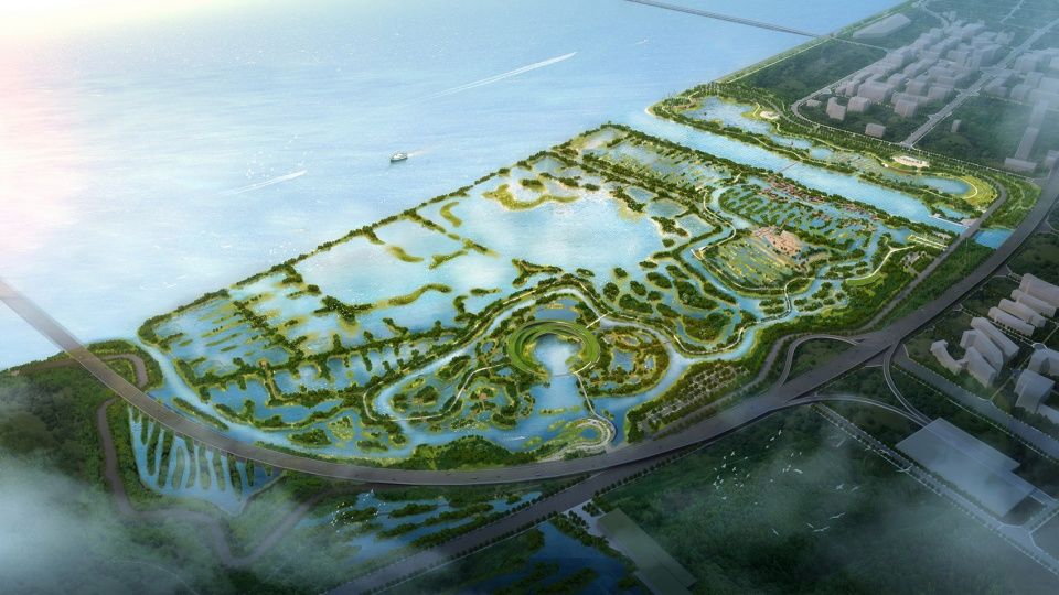
▼湿地公园鸟瞰图,bird-eye’s view of the wetland park
粤港澳大湾区背景下的横琴湿地
Hengqin Wetland in Guangdong-Hong Kong-Macao Greater Bay Area
横琴新区 | Hengqin New Area
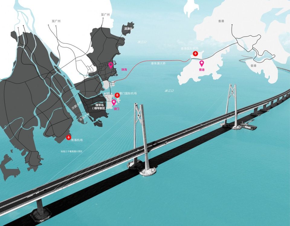
横琴新区位于广东省珠海市南部,背靠珠三角,面向南海,与澳门三岛隔河相望,随着港珠澳大桥的开通,极大的缩短了与香港之间的距离。凭借着如此优越的地理区位,横琴新区一跃成为“一国两制”下探索“粤港澳”合作新模式的示范区。
Hengqin New Area is located in the south of Zhuhai City, Guangdong Province. It faces the Pearl River Delta on northwest and the South China Sea on southeast and the Three Islands of Macau across the river. With the opening of the Hong Kong-Zhuhai-Macao Bridge, the distance between it and Hong Kong has been greatly shortened. With such a superior geographical location, Hengqin New Area has become a demonstration zone for exploring the new model of cooperation between Guangdong, Hong Kong and Macao under the “one country, two systems” principle.
▼横琴新区区位分析,zone analysis of the Hengqin New Area
横琴湿地 | Hengqin Wetland
位于横琴新区西侧的横琴湿地是本次的设计目标,湿地总面积共三百六十二公顷,是横琴新区珍贵的滨海湿地资源,同时也是历史上红树林生长的天然基地以及“东亚-澳大利亚”候鸟迁徙路线上的重要驿站。
Hengqin Wetland, located in the west side of Hengqin New Area, is the target of this design. The wetland covers an area of 362 hectares. It is a precious coastal wetland resource in Hengqin New Area, a natural base for growth of mangrove in history and an important stop on the East Asia-Australia migration route for migratory birds.
▼横琴国家湿地公园基地周边环境分析,位于横琴新区西侧,analysis of the surroundings of the site of the Hengqin National Wetland Park that is located in the west side of Hengqin New Area

在探索粤港澳大湾区合作新模式的背景下,横琴湿地在定位及功能上,将不能只局限于横琴本岛,而是需要更多的融入港澳,尤其是生态资源稀缺的澳门对于生态资源的需求。横琴湿地将不仅仅承担保护横琴新区城市安全的绿色生态屏障的功能,也将成为粤港澳生态合作的共享基地。
In the context of exploring the new model of cooperation in Guangdong-Hong Kong-Macao Greater Bay Area, Hengqin Wetland will not be limited to Hengqin Island in terms of positioning and functions, but will be more integrated into Hong Kong and Macao, especially that Macao has a need for ecological resources, for it has scarce ecological resources. Hengqin Wetland will not only undertake the function of protecting the green ecological barrier of Hengqin New Area, but also become a shared base for ecological cooperation among Guangdong, Hong Kong and Macao.
▼横琴国家湿地公园内的分区图,作为横琴新区城市安全的绿色生态屏障,the function areas of the Hengqin National Wetland Park that protects the green ecological barrier of Hengqin New Area

设计理念
Design concept
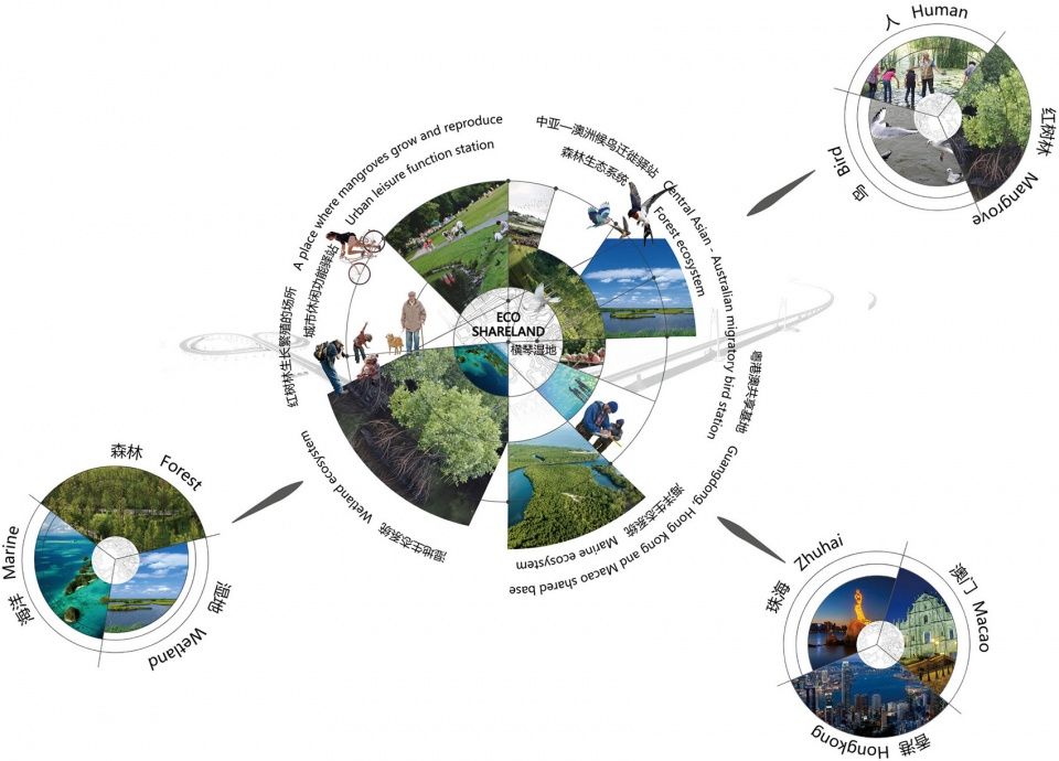
ECO-SHARELAND—鹭鸣琴海,生态共享之地是我们本次提出的设计概念,通过对场地内外部的分析,我们认为场地不仅是一处海洋、湿地、森林、城市协同发展的滨海湿地,也是一处人、鸟、树和谐共生的生态栖息,更是一处立足于粤港澳大湾区,跨域共享的生态宝地。
ECO-SHARELAND— Happy Wetland for the Birds, Ecological Sharing Land for All is the design concept we propose for the program. Through the analysis of the interior and exterior of the site, we believe that the site is not only a coastal wetland where the sea, wetland, forest and city can develop coordinately, but also an ecological habitat in which people, birds and trees live in harmony and an ecological treasure land based on and shared by Guangdong-Hong Kong-Macao Greater Bay Area.
▼设计概念分析图,concept diagram
设计目标
Design goal
通过科学合理的系统化设计,我们希望将湿地打造成为南中国共享湿地的生态典范,弹性城市的实验高地,粤港澳大湾区生态修复的新标地。
Through scientific and rational systematic design, we hope to build the wetland into an ecological model of shared wetland in South China, an experimental highland in flexible cities, and a new landmark for ecological restoration in Guangdong-Hong Kong-Macao Greater Bay Area.
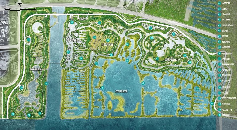
▼湿地公园总平面图,site plan of the wetland park
设计特色
Design feature
基于最小干预的生态共享模式 | Ecological sharing model based on minimum intervention
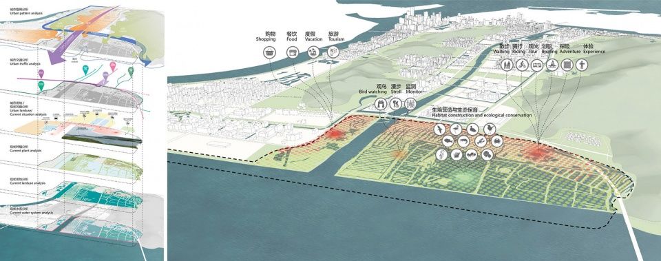
结合现状调研及大量的分析得出结论:越靠近城市界面的区域,生态系统受干扰的程度越高,越远离城市界面的区域受干扰的程度越低,生态系统越完整。基于最小干预的原则,我们提出将人的活动限制在生态干扰程度高的区域,同时遵循低干扰的设计原则,合理布局活动场地,将人对自然的干预降到最低,同时又能实现湿地科普科研及旅游等社会价值;同时将生态敏感度高的区域完全保护起来,创造红树林自然演替的生长环境,为鸟类提供栖息地。基于以上科学合理的空间规划,我们希望能够构建人、鸟、红树林多重视角下的生态共享栖所。
Combined with the current situation survey and a large number of analysis, it is concluded that the closer the region is to the urban interface, the more disturbance its ecosystem will have; the further the region is away from the urban interface, the less disturbance it will have and the completer its ecosystem will be. Based on the principle of minimum intervention, we propose to limit human activities to areas which have high levels of ecological disturbance, follow the design principle of low interference, rationally arrange the venues, so as to minimize human intervention and at the same time achieve values of popularization of science, scientific research and tourism of the wetland; at the same time, the areas with high ecological sensitivity shall be completely protected to create a natural environment for the succession of mangroves and provide habitat for birds. Based on the above scientific and rational spatial planning, we hope to construct an ecological sharing habitat for people, birds and mangroves.
▼人类活动区分布图,将人的活动限制在生态干扰程度高的区域,allocation plan of the human activity areas, limiting human activities to areas which have high levels of ecological disturbance
循环可控的水系统 | Circulating and controllable water system
横琴湿地作为滨海湿地,长期处于陆地生态系统和海洋生态系统的交错过渡地带,其生境系统独特,功能多样,具有很大的生态意义与功能价值。但是随着城市的发展,人为的干扰对这片场地产生了巨大的影响——现状一条横贯湿地外围的堤坝将湿地与外海隔绝,潮汐活动的消失意味着红树林生境被彻底破坏,滨海生态系统开始退化。继而大量的鱼塘养殖对场地的水系也产生了污染。我们决定保留现状海堤,但是增加闸口的设置,通过疏通水系,群闸连控的方式,建立一套循环可控的水系统。与外海连通区作为主要的雨洪调蓄区对城市起到防护作用,同时重新引入潮汐活动,恢复红树林生长的生境条件。水位控制区则严格控制水位,满足日常游憩必备的基础设施的建设需求,只在紧急时刻可开放水闸承担调蓄作用。水位控制区的水源可通过城市雨水收集、水库补水以及风力设施提水三种方式进行补给,并且设置两处水体净化区对来水进行净化。
▼湿地公园内水系统设置分析图,the water system inside the wetland park
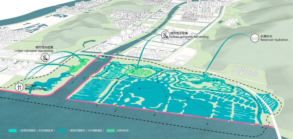
As a coastal wetland, Hengqin Wetland has long been in the interlaced transition zone between terrestrial ecosystem and marine ecosystem. Its habitat system is unique and has diverse functions, with great ecological significance and functional value. However, with the development of the city, human disturbance has had a huge impact on this site. The current situation is that a dam across the periphery of the wetland separates the wetland from the open sea. The disappearance of the tidal activity means that the mangrove habitat is completely destroyed and the coastal ecosystem starts to degenerate. Then a large number of fish culture in ponds have also polluted the water system of this site. We decide to keep the current seawall, but increase the setting of gates. By dredging the water system and controlling group gates jointly, establish a set of circulating and controllable water system. The area connected with the outer sea serves as the main rain and flood storage area to protect the city. Meanwhile, tidal activities are reintroduced to restore the habitat conditions for mangrove growth. The water level control area will strictly control the water level to meet needs to construct infrastructure necessary for daily recreation. The floodgate can only be opened in emergency to regulate or store water. The water source in the water level control area can be replenished by three methods: urban rainwater collection, reservoir water replenishment and water lifting by wind power supply. Two water purification areas are provided to purify such water.
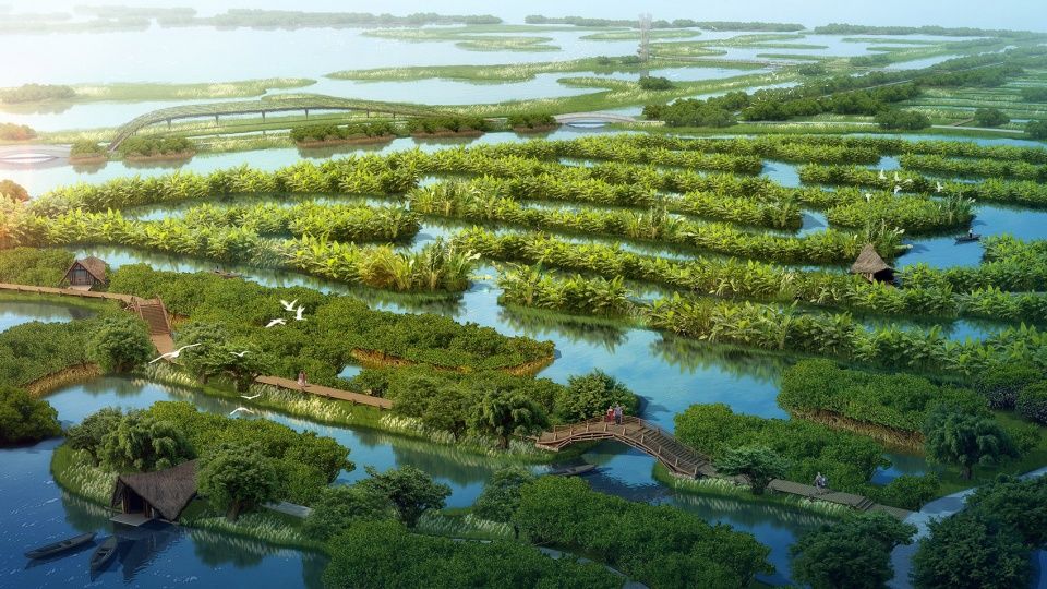
▼保留场地中蕉基鱼塘的肌理,穿梭在蕉林中,体验果树采摘的乐趣,the texture of the banana-based fish pond in the site is retained. Shuttling through the banana forest, visitors can experience the fun of picking fruits from trees
弹性减灾的绿色生态系统 | Green ecosystem for reducing disasters flexibly
结合水系规划,外海连通区重新引入了自然的潮汐运动,满足了红树林生长的基本条件。在此基础上,我们协同专业团队进行详细的场地调研,确定了能在此生长的红树林品种,分别是秋茄、木榄、桐花树、老鼠簕等。针对这些具体品种的生态习性和生境需求,我们做了深入的研究,取得了一些相关科学数据。通过对红树林生境的重建和复育,恢复以红树林为主的滨海湿地生态系统,充分发挥红树林群落在抵御海潮、风浪等自然灾害方面的生态功能,真正起到“海洋卫士”的功能与作用。
▼场地调研分析图,以确定在此生长的红树林品种,diagram of the site analysis to determine the mangrove species

▼红树林生境分布图,充分发挥红树林群落在抵御海潮、风浪等自然灾害方面的生态功能,allocation map of the mangrove habitat, making best use of the ecological functions of mangrove communities in resisting natural disasters such as sea tides, winds and waves

Combined with the water system planning, the area connected with the outer sea has reintroduced natural tidal movements to meet basic conditions for mangrove growth. On this basis, we have conducted detailed site research with professional team to determine the mangrove species that can grow here, namely kandelia candel, bruguiear gymnorrhiza, aegiceras corniculatum, and acanthus ilicifolius. Based on ecological habits and habitat needs of these specific varieties, we have conducted in-depth research and obtained some relevant scientific data. Through reconstruction and rehabilitation of mangrove habitats, the coastal wetland ecosystem with mangroves as the key parts will be restored to put into play ecological functions of mangrove communities in resisting natural disasters such as sea tides, winds and waves. In this way, function of mangroves as the “marine guard” will be fully realized.
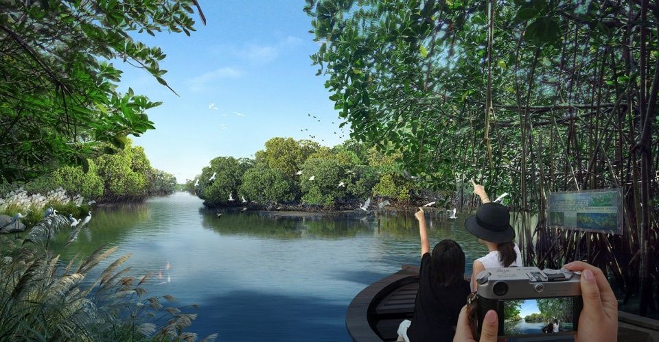
▼乘船深入红树林湿地深处,近距离感受红树林的魅力,take a boat to go deep into the depths of the mangrove wetland to experience the charm of the mangroves closely
科学严谨的鸟类栖息地营造 | Construction of a scientific and rigorous bird habitat
横琴岛鸟类资源丰富,且处于“东亚-澳大利亚”迁徙线上,秋冬季节有大量的鸟类在此栖息。相较于珠海淇澳岛红树林湿地是以红树林植物多样性展示为主,横琴岛红树林湿地将更多的展现其作为鸟类栖息地的功能与意义。我们寻求鸟类专家的帮助,确定有哪些鸟类会在此驻足停留,并且通过对鸟类空间分布、生活习性及具体生境条件的系统性研究,构建不同鸟类所需的栖息地环境,最终实现鸟类的招引与保护。
▼鸟类栖息地分布图,allocation map of the bird habitat

Hengqin Island is rich in bird resources and is on the “East Asia-Australia” migration line. Therefore, there are a large number of birds inhabiting here in autumn and winter. In the mangrove wetland in Qi’ao Island of Zhuhai, the main purpose is to display the diversity of mangrove plant. In Hengqin Island, the mangrove wetland is more to show its function and significance as a bird habitat. We seek the help of bird experts to determine which birds will stop here and build a habitat environment for different birds through systematic studies of bird spatial distribution, living habits and specific habitat conditions, so as to realize the goal of attracting and protecting birds.
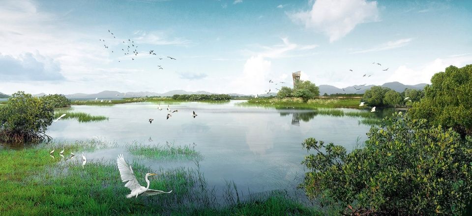
▼多样的生物栖息地,远离人群的小鸟天堂,habitat of diverse living things and a bird paradise away from the crowd
低干扰多层级的交通网络 | Low-interference and multi-level traffic network
交通网络的布局主要集中在人流活动区,采取整体串联,内部成环的方式形成连续便捷的慢行网络。在人流活动区与生态保护区的过渡区域局部设置尽端休憩平台及观鸟塔,以低干扰的方式进行科学监测及科普展示。同时设置水底通廊、沉水廊道、空中栈桥等水陆空多层级的低干扰路径,形成趣味便捷的生态交通网络。
▼人行步道的交通网络分析图,diagram of the human circulation network
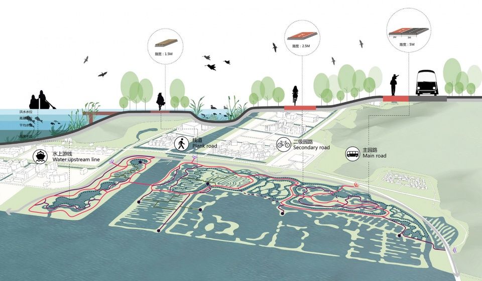
The transportation network is mainly in the pedestrian area. Through overall connection and internal looping, a continuous and convenient slow network is formed. In the transition area between the pedestrian area and the ecological protection area, end rest platforms and bird watching towers are set up in some parts, so as to carry out scientific monitoring and scientific display in a low-interference way. At the same time, a low-interference and multi-level sea-land-air path which has underwater corridors, submersible corridors and aerial trestles is set up to form a fun and convenient ecological transportation network.
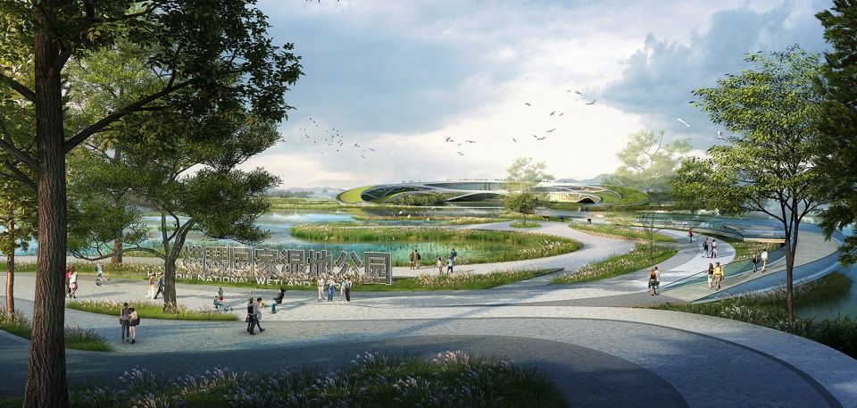
▼入口广场以海浪曲线为主题,极具动感与视觉惊喜,the entrance plaza takes the wave curve as the theme, which is very dynamic and visually pleasant
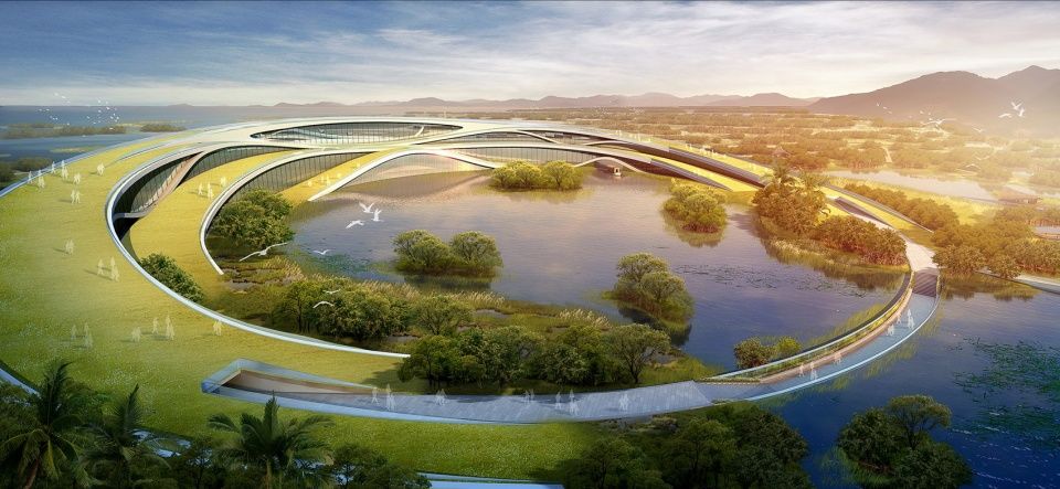
▼游客服务中心采用覆土建筑的形式成为场地中心的绿色空间,提供多条穿越路径,the tourist service center is a green space in the center of the site because it is a earth-sheltered building, providing multiple crossing paths
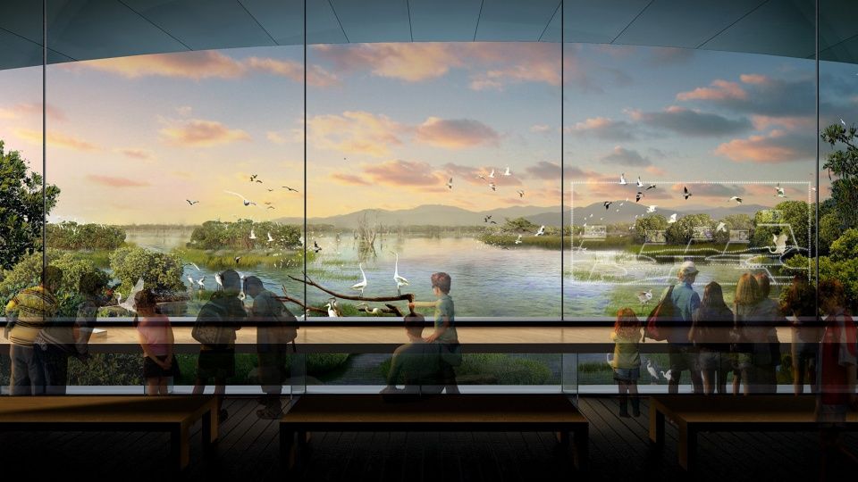
▼透过全透明的玻璃幕墙,将鸟类生活展现在眼前,life of birds is presented to visitors through a fully transparent glass curtain wall
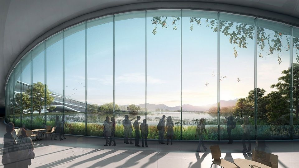
▼游客服务中心通透的内外部空间,成为游客观赏湿地和休憩停留的场所,the tourist service center is a place for visitors to watch the wetland and rest because its exterior and interior spaces are transparent
▼完全沉入水底的特色通廊,以全新的视角展示湿地,a characteristic gallery that completely sinks into the water, showing the wetland in a new perspective
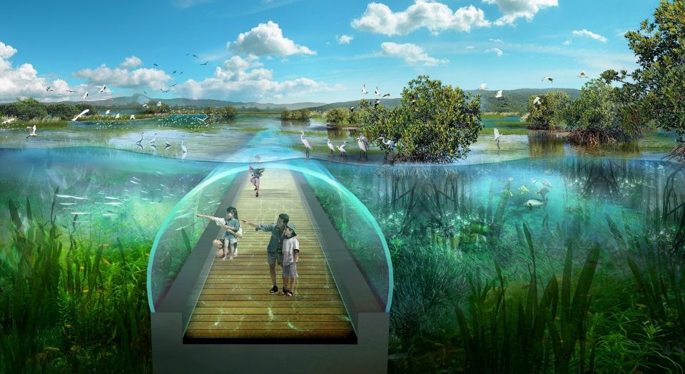
▼沉水廊道两侧有玻璃幕墙隔着湖水,游人可近距离观察湿地水下环境,there are glass curtain walls on both sides of underwater corridors to separate the lake, so visitors can observe the underwater environment of the wetland closely

▼捉泥鱼、编制鱼笼,感受非遗的文化魅力,while Catching mud fish and making fish cage, you can feel the cultural charm of intangible cultural heritage

项目名称:广东珠海横琴国家湿地公园概念方案设计
设计:GED 杭州格境建筑景观设计有限公司
项目设计年份:2018年9月设计
主创及设计团队:江哲炜、许立南、张蕾、陈灵斐、徐旋、季玉琪、林坚玮、胡雨、钱景、曹赟
项目地址:广东珠海
建筑面积:公园规划面积3.26k㎡,其中建筑面积4.27万㎡
合作方:南京市园林规划设计院有限责任公司
客户:珠海蓝湾建设开发有限公司


