法明顿城市景观规划 | 智能城市农业与环保设计的融合
Townscaping an Automobile-Oriented Fabric: Farmington, Arkansas By University of Arkansas Community Design Center, Fayetteville, AR
更多请至:
"This project references the vibrant farming community of the 1940s and 50s. It is an intervention that is edible. There is a remediation for each approach to town. This is an unromantic problem that is solved in a dignified way. The right of way is public space and this is the beginning of rethinking how to use public space for public good."
—2013 Professional Awards Jury
“该项目参考了20世纪40年代、50年代曾经繁荣的农业社区景象,是一次“可食用”的嵌入式景观设计,是对传统城市道路观念的修正,也是用浪漫处理平庸的成功实践。此次改造的主体是公共空间,启示我们重新思考如何以公共利益为出发点利用公共空间。”—2013专业奖评审委员会项目描述:法明顿城市景观规划将郊区共有五条车道的商业大道改造成为可种植瓜果蔬菜的复合型林荫大道,让这个拥有5000人口曾经繁荣的农业区焕发新的活力。景观规划通过节点的连续性组织,在汽车当道的城市背景中创造一个适于步行的环境,同时在不依赖资本密集型建筑投资的情况下提高都市生活的品质。此次规划目标是从以下三个方面构造一个经典的城市网络:1.农业城市化;2.环境敏感性的公路设计;3.公共艺术规划。
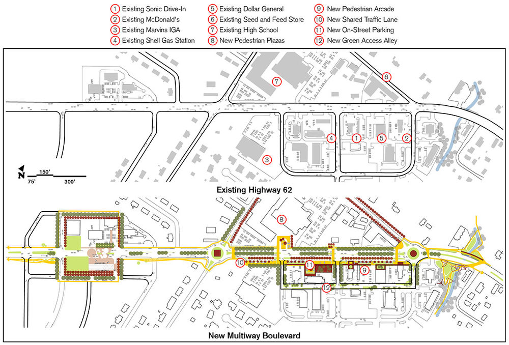
▲走廊重建成舒缓交通和种植食物的城市空间系列 The Corridor is Restructured as a Series of Urban Rooms that Calm Traffic and Bear Food
The planning area captures the town’s commercial base located south of the highway, opposite public school facilities, a senior citizen community center, city hall, and safety service facilities.
规划区域占据了公路南端的城镇商业基地,与学校、老年人社区中心、市政厅及安全服务设施相对。
1.法明顿曾经是美国最大的苹果种植区内的农业区。据估计,20世纪初40%的苹果和梨产自西北部的阿肯色州。该城市景观规划期望重塑当地的农业景观,重拾法明顿的农业遗产。当地的种植传统为发展农业提供了便利,同时也是发展当地经济、创造就业机会的利器。在城市公共通行道上发展农业景观(“可食用的景观”)网络将重新唤起法明顿已经丢失的农业传统,这样不仅能保证食物供应的持续性和安全性,还能有效促进健康生活方式的养成。整个景观网包括果树园、盆栽花园、葡萄园、墙树园(“植物造景”)。基于某些植物净化空气和水源的作用,另外一些植物具备的营养循环、维护土壤或综合防治病害虫的功能,设计者们将城市景观设计成一个复合式的生态系统。
2.提供一个环境敏感性的公路设计模型,提高SR62生态和城市服务的交付。美国联邦公路管理局给出了如下定义:“环境敏感性解决方案(CSS)是保证交通安全性和连通性的同时,把开发一个交通建设项目相关的所有元素(如自然环境、景观,美学,历史,和环境资源等)都考虑周全的设计方案。”该项目将高速公路改建成与沿路的学校、机构部门和商业区和谐相融的林荫大道。南部商业区边缘的临街系统建设方案将会带来大量行人。
3.通过引导标志、建筑物正面、街道设施、灯光、雕塑、纪念碑、景观和其他城市配件等公共艺术的应用发展环境导示系统。在初始阶段,将普通元素的结构和象性特征进行重新组合便可制造出独特的城镇风景。艺术功能增大了这些普通元素的可塑性,避免了公共艺术的孤立感。
环境/社会数据及分析方法
分析法明顿上个世纪受人口增长和生存方式改变的影响而不断变化的城市形态。法明顿曾经是美国最大苹果种植区的可持续市区农业加工中心,其重要性远高于周围的其他城镇。然而,时过境迁,周边城镇仍保持着城市核心,而法明顿却已成为它们的郊区。环境敏感性公路设计和城市建筑的改造方案将改变不规则的汽车导向型格局—高速商业走廊、小块农场和汽车零售。该区域的农业遗产激励了城市小面积农业区域的研究和发展,以重新唤起已经丢失的农业文化。
选择权和公众参与
项目组设计了一个包含公路建设一般要素的“公路生态矩阵”,并根据不断升级的服务水平进行分类。作为非设计人员进行城镇景观规划的理想工具,该矩阵帮助参与其中的市民共筑美丽市容,方便对公路区块进行个性化设计,即环境敏感性设计。(美国)全国艺术基金会2010年“通往卓越艺术”项目赞助了包含社区研讨会,民间组织、学校及区域规划机关研讨会在内的项目策划。
设计的重要性
设计思想形成了“无形环境”问题的解决方案,构成了间距式城市化进程的纽带。设计向我们展示了如何通过智能城市农业接口和公路生态矩阵的组合提供多渠道再开发解决方案。
项目实施
规划成果将用来取得阿肯色州公路与运输局(AHTD)2013年交通设施优化基金,用于第一期工程的建设(包括河岸走廊工程)。目前,法明顿正在与业主讨论,希望可以临近公路,为城市中心的发展争取更大的区域空间。
项目管理
法明顿市政执政官将在阿肯色州西北部区域规划委员会规划人员的协助下负责设计提案的执行,与阿肯色州公路与运输局共同实施环境敏感性公路建设工程。当地市民俱乐部的筹款用于城镇景观非公路工程的建设。

▲法明顿曾是世界果园Farmington was once the World’s Orchard
Farmington was once a substantial downtown agricultural processing center in one of the country’s largest apple-growing regions. It is estimated that 40 percent of the apples and pears grown at the turn of the 20th century were grown in Northwest Arkansas.
法明顿曾经是美国最大的苹果种植区内的农业区。据估计,20世纪初40%的苹果和梨产自西北部的阿肯色州。
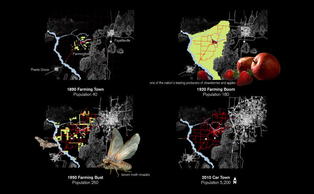
▲法明顿的演变The Evolution of Farmington
Mapping analyses chronicle Farmington’s changing urban morphology, where it was once a center of agricultural processing. Now, Farmington is a bedroom community to surrounding communities, which have retained their downtown cores.
分析法明顿不断变化的城市形态—曾经是农业加工中心的法明顿现已成为始终保持城市核心的周边城镇的郊区。
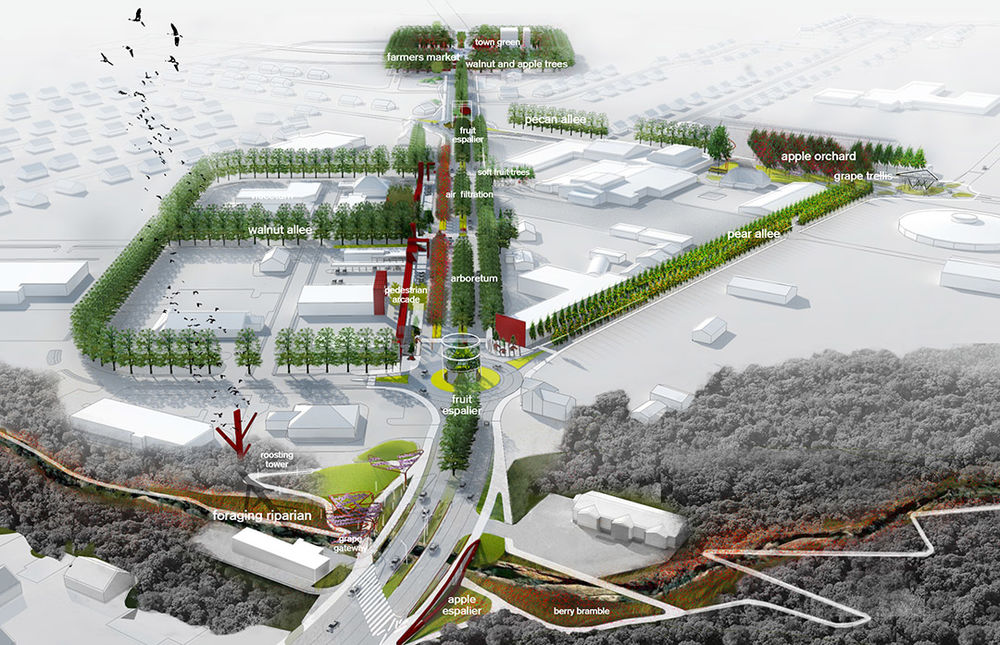
▲重建当地食物景观Re-establishing a Local Foodscape
The project proposes a “productive” landscape, which functions as a continuous public network integrating urban and ecological systems. Akin to a public utility, the network defines new public spaces, blocks, neighborhood edges, and transitions between the town fabric and its riparian corridor, recalling Farmington’s lost agricultural heritage.
该项目设计了一个“生产性”景观,构成了连接城市和生态系统的公共网络。与公共设施相似,该网络定义了新公共空间、街区、邻区边缘及城镇构造与河岸走廊的过渡区域,唤起法明顿丢失的农业传统。
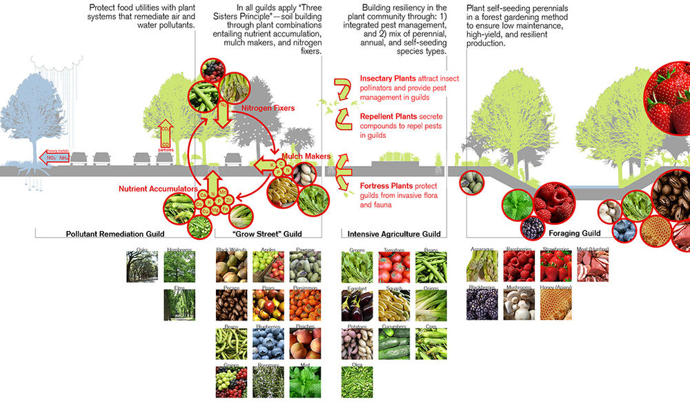
▲智能城市农业接口重拾丢失的农业遗产 Smart Urban Agricultural Interfaces Reclaim a Lost Agricultural Literacy
Urban landscapes are designed as laminated ecosystems since some plants are optimal remediators of air and water pollution, while others favornutrient cycling and soil husbandry or integrated pest management.
基于某些植物净化空气和水源的作用,另外一些植物具备的营养循环、维护土壤或综合防治病害虫的功能,设计者们将城市景观设计成一个复合式的生态系统。
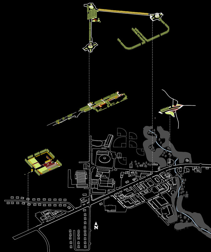
▲第三期:地标 Phase 3: Accentuate with Landmarks
Triangulate school and commercial zones with traffic roundabouts that replace traffic signals, accompanied by public art with novel urbanized agricultural structures.
学校、带交通环道(取代交通信号灯)的商业区、及新颖城市化农业结构的公共艺术。
第二期: 景观框架和新街道几何结构Phase 2: Frame with Landscape and New Street Geometries
Connect gateways with new street geometries, incorporating a multiway boulevard, a green access alley, bike and pedestrian trails, and urban agricultural systems.
连接城市门户通道与新街道,包含复合型林荫大道、绿色入口小径、自行车道和人行道、城市农业系统。
第一期: 连接门户通道Phase 1: Bound with Gateways
Demarcate entries into city services complex and commercial strip with town gateways.
通过城镇门户通道划分城市服务综合和商业地带的入口。
现有环境Existing Context
The town’s nondescript commercial and institutional hub is a low-density, single-use zoned fabric serviced by a five-lane arterial highway.
城市当前不规则分布的商业和机构中心密度低、功能单一,五条车道的公路干线穿梭其间。
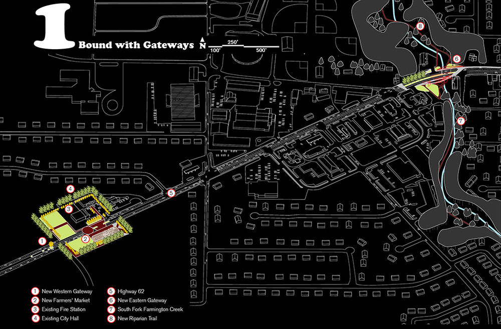
▲第一期 在走廊端点发展城市门户通道,划定城镇中心
Phase 1 Develop urban gateways at corridor endpoints, delimiting the town core.
The town green gateway proposes a green space around which a new year-round regional farmers’ market, existing city hall and fire station, and future private development are to be located.
The riparian gateway marks transition to the riparian corridor trail and foraging landscapes below.
城镇的绿色通道应是一个绿色空间,周围是现有的市政厅和消防站、及未来发展的全年开放的新区域性农贸市场和私人开发项目。风景迤逦的河岸门户通道是通往河岸走廊的过渡性结构。
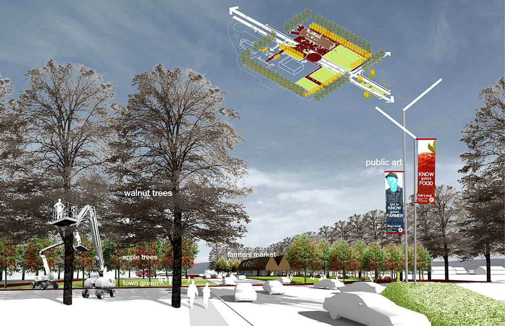
城镇绿色门户通道Town Green Gateway
Establish a town green with orchards and a new farmers’ market pavilion at the west gateway that organizes scattered assets (i.e., buildings and parking lots) into a coherent, identifiable, urban realm.
西部门户通道处的果园和新农贸市场将打造一个绿色城镇,并将分散的城镇结构(如建筑和停车场)有序地组织成连贯的特征明显的城市区域。
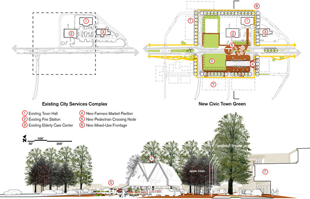
▲农贸市场和绿色城镇Farmers’ Market Pavilion and Town Green
Develop a year-round farmers’ market to process regional food products, and to host multiple community events – Farmington’s best porch.
建立一个处理当地食品的全年开放的农贸市场,举办多社区活动,构造法明顿最好的展示平台。
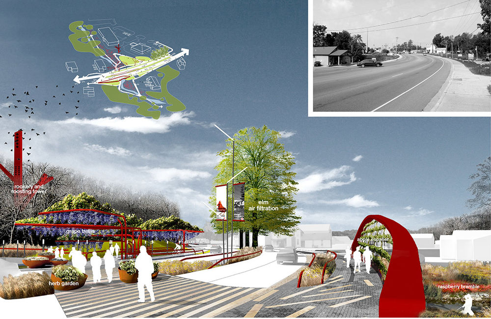
▲大桥Riparian Bridge Gateway
Develop the intersection between highway and riparian greenway with agricultural urban components and new bridging elements. The eastern gateway serves as neighborhood threshold organizing scattered assets (i.e., buildings, bridges, Parking lots, and streams) into a coherent, identifiable, urban realm.
用城市农业元素和新的桥渡元素开发公路和河岸绿色通道之间的交叉区域。东部门户通道将分散的城镇结构(如建筑、桥梁、停车场和河流)有序地组织成连贯的特征明显的城市区域。
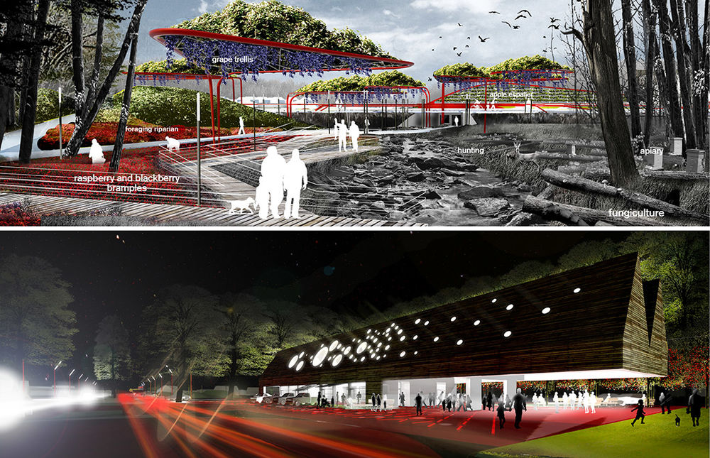
▲法明顿门户通道Farmington Gateways
Designed for food production and processing, the combined landscape and street system, serves as public armature ordering future infill development between the gateway.
为食品生产和加工而设计、景致迷人的街道系统勾勒出门户通道之间区域的未来补充性发展。
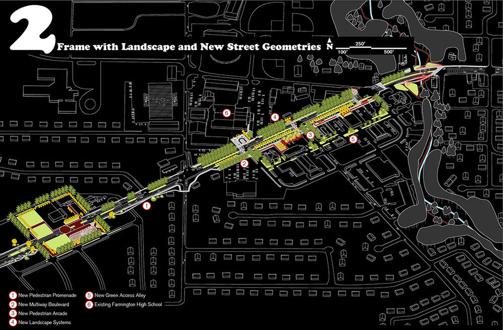
▲第二期Phase 2
Focused on infill, phase two introduces new right-of-way geometries between gateways, including a food-bearing multiway boulevard that accommodates regional and local traffic with bicycle and pedestrian facilities. New pedestrian crossings and nodes connect the commercial sector with public school facilities across the corridor, creating a safer multi-modal realm.
第二期关注补充性开发,在门户通道之间引入优化的道路新布局,包括根据地区和当地交通情况设由自行车道和人行道、并可种植食物的复合型林荫大道。纵横的人行道穿过走廊连接商业区和公立学校,创造一片更加安全的多元化区域。
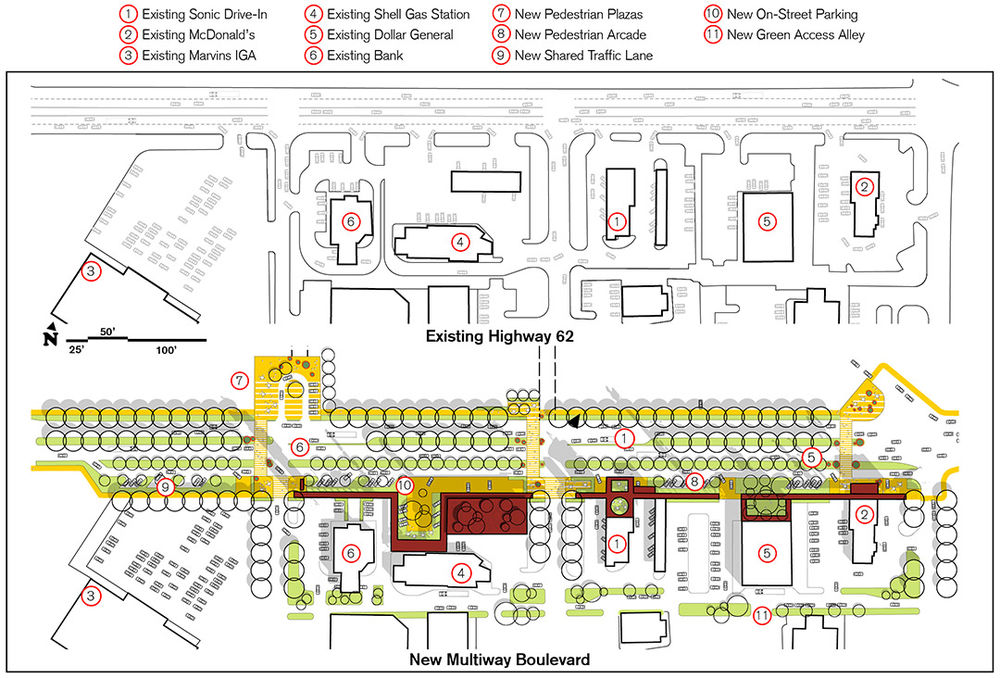
▲种植食物的新复合型林荫大道和人行道规划New Food-Bearing Multiway Boulevard and Pedestrian Interface Plan
The multiway boulevard can accommodate existing land uses while developing a “food utility” that provides access to local food production and can be foraged. Retrofits also accommodate multiple modes of transit, including pedestrian, bicycle, and local as well as regional automobile traffic.
复合型林荫大道适应当前土地使用需求的同时可发展成“食物设施”—食物种植基地,更多的可能性有待开发。改造后的道路能满足多种交通形式的需要,如步行、自行车、当地及地区范围内的汽车。
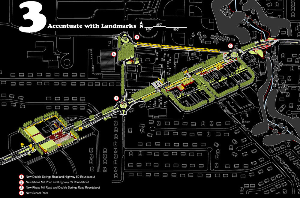
第三期 用空间划分和城市艺术代替工程设备,实现交通稳静化(不减少交通量)(Phase 3 Traffic calming (without diminishing throughput) is achieved through spatial definition and civic art in lieu of engineering devices.)
Phase three substitutes roundabouts for traffic signaling at two key intersections within the corridor segment. roundabouts extend the gateway features and are accentuated with public art structures featuring signage and urban agricultural living walls.
第三期用环形路代替走廊区域内两个主要十字路口的交通指示灯。环路延伸了门户通道的特性,具备指示功能和以城市农业生态墙为特征的公共艺术结构又进一步凸显了这一区域。
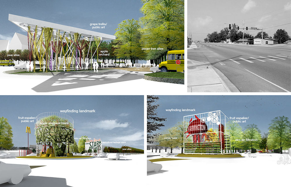
▲公共艺术—环路Roundabouts as Public Art
Besides maintaining continuous traffic flow, roundabouts rationalize awkward and dangerous street intersections while enhancing street aesthetics with wayfinding landmarks that combine public art and urban agricultural espaliers. The roundabout with an accompanying plaza at the public school facilities connects sports facilities with academic buildings severed by the road.
环路不仅保证了交通的通行性,还使不规则的危险街道交叉口趋于合理。同时,结合了公共艺术和城市农业树墙的的指示性地标强化了街道的美学特征。公立学校区域附带广场的环路将运动设施和被公路分隔的教学楼连接起来。
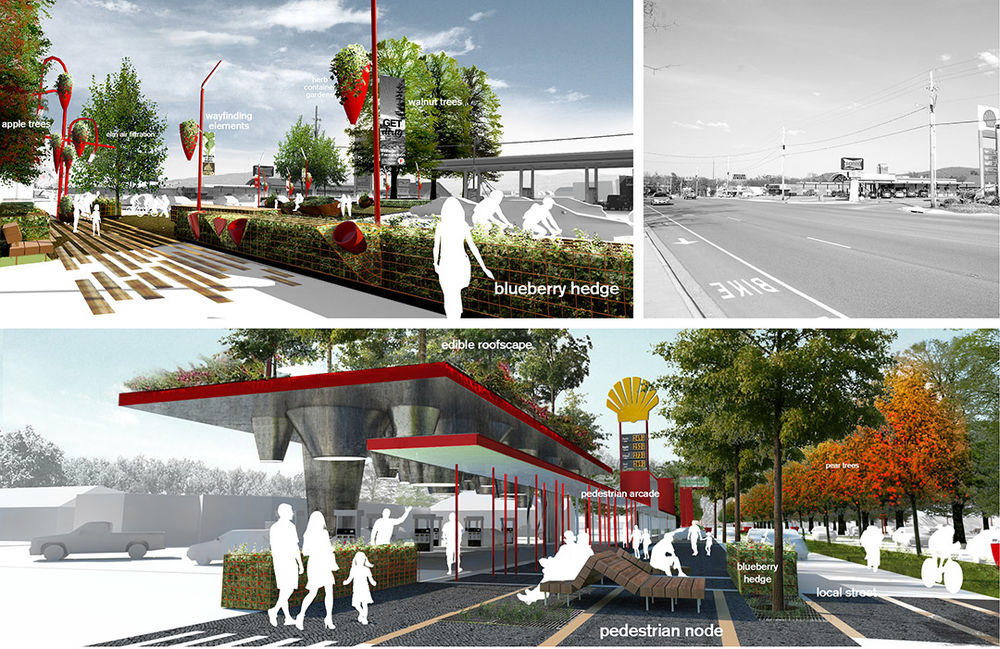
▲种植食物的新复合型林荫大道和人行道Food-Bearing Multiway Boulevard and Pedestrian Interface
Coupled with a new “food utility”, ordinary street accessories related to lighting, signage, paving, shelter, and furniture civilize the corridor, creating a pedestrian-oriented frontage system that incents better use of the land.
新的“食物设施”与普通的街道设施(如路灯、指示灯、辅路、蔽荫处等)共同塑造了一个文明化的走廊,创造了一个以步行为主导的临街系统,引领着土地开发的良性发展。
Project Statement
The Farmington townscape plan retrofits a suburban five-lane commercial arterial into a food-bearing multiway boulevard, revitalizing this once vibrant 5,000-person farming community. Townscaping employs a serial organization of nodes to create a walkable urban environment within an automobile-oriented context. Townscaping proposes an incremental urbanism without reliance on capital-intensive architectural investments. The goal is to evolve a memorable town fabric through three place-making strategies: 1) agricultural urbanism, 2) context-sensitive highway design, and 3) public art planning.
Project Narrative
Farmington was once a substantial agricultural community in one of the country’s largest apple-growing regions. It is estimated that 40 percent of the apples and pears grown at the turn of the 20th century were grown in Northwest Arkansas. The townscape plan proposes to re-establish a local foodscape, recalling Farmington’s agricultural heritage. The convenience provided by proximity to growing systems demystifies farming and positions it to be a tool for local economic development and jobs creation.
1. Develop an urban agricultural landscape network of civic food-bearing landscapes – edible landscapes – in public right-of-ways, recalling Farmington’s lost agricultural heritage. This provides local food supply resiliency and security, while democratizing access to improved nutrition and healthy lifestyles. Landscapes include fruit-bearing arboretums, foraging landscapes, herbaceous container gardens, trellised vines, and espaliers (


