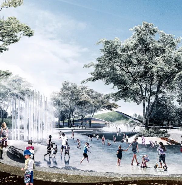
“从开敞的空地到隐蔽的树林,这项方案为人们带来了不同类型的空间和体验。实在非同凡响。” – 2018年评奖委员会
“The plan allows for and encourages different experiences in the different spaces, from being wide open and being fully engaged with the people around you to intimate, forested places. It’s remarkable.” – 2018 Awards Jury
项目概述 PROJECT STATEMENT
布鲁克林大桥公园在去年接待了500万名游客,其中包括当地居民、附近城市的居民以及来自世界各地的旅客。在经过长达20年的规划和建造之后,这一占地83英亩的后工业滨河区域终于接近完工。不过,自2010年首期工程开放以来,布鲁克林大桥公园便已经成为城市生活的一部分。为了使这一规模宏大的项目得以顺利实现,设计团队在项目初期便着力于解决场地本身所带来的各种挑战,同时最大程度地发挥其有利条件。附近的街区借助公园与功能丰富的城市节点重新形成了连接,而首个码头的改造则针对各类水边活动和公众活动进行了优化。项目初期的高标准设计为后期工程的实施和创新奠定了基础。新的公园将凭借一系列富有创新性的水边设施为当地居民带来更优质的环境,同时也将使自身在城市中的影响力得到进一步扩大。
Last year Brooklyn Bridge Park welcomed 5 million visitors: a mix of locals, far-flung metro area residents, and tourists from around the world. After twenty years of planning and construction, this 83-acre transformation of a post-industrial waterfront is almost complete, but the park has been a fixture in city life since the opening of its first segment in 2010. Having planned this ambitious project to be built incrementally, the designers focused the initial phases on the site’s toughest challenges and greatest assets. Adjacent neighborhoods severed from the park site by city infrastructure were reengaged with program-rich urban nodes at existing connection points, while the first pier transformations were optimized for a range of water’s edge activities, civic events and active program. Faced with challenging site conditions, the high standards for ecological performance set early in construction guided later phases and prompted further innovation. The combination of a locally-focused city edge and a transformative experience of the water cemented Brooklyn Bridge Park as a city park first, but one whose reach continues to grow.
▲2005年的布鲁克林滨水区。5英亩的码头区延伸至东河,位于外延的建筑体量较轻,高处的地面则较为坚实,同时种有树木。Brooklyn Waterfront 2005. The enclosed 5-acre piers extend over the East River, while the paved upland is on solid ground, resulting in a composition of lightweight uses on outboard piers, with more robust topography and planting at the uplands. Photo Credit: Elizabeth Felicella
项目说明 PROJECT NARRATIVE
社区参与 + 激发灵感
布鲁克林大桥公园的建造历时多年。公园的景观建筑师在1998年曾作为多学科团队中的一员为超过1英里的布鲁克林滨河区域制定初期的经济发展计划。5年后,景观建筑师们被选为公园总体规划的首席顾问,最终使项目得以落成。
在规划的初期阶段曾经产生过许多问题,例如:是否真的有人愿意使用一个与附近社区并不相邻,且受到多层次的布鲁克林-皇后区高速路阻隔的公园?公园该如何处理自身与河岸的关系?还有更重要的是,这个公园应该被建造成什么样子?它如何利用现有的条件来吸引足够多的游客从而得到更长远的发展?在之后的几年里,景观建筑师与当地居民和社区团体进行了大约300次会议,旨在使这些问题得到有效的解答。据与会者回忆,在1999年,一位来自布鲁克林高地区的居民在会议中说道:“我年纪大了,靠着固定的收入生活。我大概难以再去乡下度假,但我希望能够在晚上到公园的东河边走走,把脚放在水里,看看月亮的倒影。”
这位居民的发言引起了设计师的共鸣。人们断然不会拒绝纽约港、东河以及曼哈顿城区的壮观景色,但美景却并不足以支撑公园的长期发展——河岸必须成为一个能够被人们使用和享受的地方。为此,设计团队竭力营造与河岸互动的机会,将原先陡峭的河堤改造为复杂而多变的空间和路径,使人们能够与河水亲密接触。
恢复力 + 基础设施
设计师们知道,这座公园必须十分耐用,才能够抵御这一低洼场地每日面临的潮汐压力,以及东河随时可能发生的雨后洪水。为了同时兼顾功能性与恢复能力,设计师引入了一种全新的边缘类型,能够在提高环境能效的同时优化河岸的使用体验。以乱石砌筑的河堤成为了贯穿项目的万能工具:不仅价格低廉,在抵御潮汐和风暴潮时的表现也比防渗墙更胜一筹,同时还可以被塑造为各种不同的形态。石砌的堤岸不仅让整个场地实现了材料上的统一,还能够提供非正式的座位、用于船只入水的斜坡,并起到遮挡植物、改善海洋栖息环境和应对潮间带生态变化的作用。
建造于1号码头的盐沼是公园中最具雄心的改造成果之一。基于专家顾问的密集研究和测试,这一高度工程化的盐沼使优质的生态环境重新回到城市滨水区,并在公园的边缘地带形成一个新的潮间区域。此外,鉴于其在遭遇飓风桑迪之后迅速地恢复了原状,这片盐沼还成为了大型盐沼和防洪设施的重要试验场。与潮汐环境(特别是盐沼)的密切联系让布鲁克林大桥公园成为了开展环境教育课程的最佳场地。
改造工业化的海岸线对于设计者而言可谓一项挑战,不过他们最终在残留的港口基础设施中找到了机会:通过大量的结构分析,那些仍有挽救余地的码头被赋予了新的用途。1号码头几乎是在原来的基础上填充而成,而非建造新的结构。该区域能够承受较为强力的地形干预,包括从地铁废墟改造而来的倾斜草坪。原先较为脆弱的桩柱结构被拆除,并在原地修建石堤,以形成盐沼。2号码头和5号码头则更加稳定,分别作为草坪运动场和硬地网球场使用,从而在不超过承载能力的前提下获得了更加完善的功能。码头上原先的仓库建筑被赋予了新的功能,起到遮风挡雨和照明的作用。
活动 + 城市环境
项目在第一阶段的重点是将布鲁克林大桥旁边的既有滨水旅游区和开发不甚充分的大西洋街道(一条重要的商业走廊)被连接起来。公园的两个主入口处设有食品店和轮渡站,与城市生活形成紧密的连接,并促使公园入口成为城市中的节点。1号码头的宽阔场地常常会用于举办特别的活动,将大量人群吸引过来;在平时则能够满足更加普遍的需求,例如用作儿童游戏场地、运动场、日光浴场和观景场地等。
2号码头和5号码头旨在最大程度地改善娱乐体验,以满足布鲁克林市中心的使用需求,同时将整个城市里的人们吸引到东河下游地带,鼓励他们进行游戏和锻炼。2号码头设有三个全尺寸篮球场、手球场、运动健身器材、溜冰场以及多用途的草地。5号码头在此基础上还增加了额外的5英亩草坪,从开放以来便持续投入使用,为公园吸引了大量的居民和游客。公园的第三个入口与位于5号码头、面积达4万平方英尺的野餐半岛相连,市民们可在风景如画的公共烧烤平台上充分享受美食。
特征 + 遗产
公园的景观体验与功能区域形成了紧密的结合,包括繁茂的灌木篱墙、盐水和淡水湿地、草地以及供儿童游玩的小树林。这些充满生命气息的景观均是对当地资源善加利用的结果,种植在其中的植物种类也经过了仔细的挑选,能够适应盐碱和多风的环境。对场地雨水的再利用能够基本满足公园的灌溉需求。篱墙和下层植被以小型的灌木为主,便于成活和塑形。自2010年以来,设计团队与公园的园艺师进行了密切的合作,对多种已经成熟的植物进行了维护和改良。
考虑到功能和景观的多样性,设计团队需要为公园赋予整体的连贯性,才能够使其与场地丰富的文化历史保持联系。 公园中很大一部分实体结构是由回收的材料打造而成,包括拆除城市桥梁后留下的石材,以及被拆毁建筑中的老松木横梁等。新加入的材料和装置也都十分简洁耐用,且能够适应城市的沿海环境,包括镀锌钢、石砌路堤和天然抗腐蚀的围栏等等。
布鲁克林大桥公园的成功来源于其设计者对场地现状全面细致的考量。这一新的生态系统作为城市体验的一部分,在人口稠密的城市中心逐渐成长起来。纽约的市民们可以在距离盐沼地仅数英尺远的草地上举办夏季电影节。这座公园为人们带来的并不只是可以看见的美景,更是可以实实在在为人们所用的城市设施。布鲁克林大桥公园在未来将聚集更多城市乃至其他地区的居民,确保拥有广泛的民众基础,以形成一个长久发展的文化场所。
▲2号码头的运动场。该场地提供了篮球、手球和轮滑场地,原先的仓库建筑也被改造为新的公共设施,共同形成了一个为年轻人所喜爱的活动中心。Pier 2 Sports Courts。Known to Brooklyn youth as “The Piers,” facilities for basketball, handball, roller skating, and more carved out of the original warehouse structure makes this space near the park’s center a hub of activity for young people.
▲2号码头开放至夜间11点。充满活力的社交空间在夜晚成为城市生活的灯塔,与周围更加宁静的自然环境形成互补。Night lighting at Pier 2 allows games to go on until 11:00pm. In the evening the pier is a vibrant social space and a beacon of urban life to complement its more peaceful landscape surroundings.
▲从公园下方经过的六条地铁线之一被改造为景观,螺旋式的坡道取代了原先摇摇欲坠的混凝土舱壁。以乱石砌筑的河堤构成了皮划艇的入水区,同时能够抵御强烈的飓风。One of six subway lines passing under the park is relieved of a massive soil volume, as the Spiral Ramp replaces a crumbling concrete bulkhead. Riprap shapes this kayak entry point and armors the shore against storms like Hurricane Sandy.
▲通向1号码头的无障碍通道。随着时间的推移,幼树林将长成茂密的金色天顶。公园的修建对公共资金进行了妥善而充分的利用。An Accessible Path at Pier 1. The sumac thicket, which provides immediate canopy and striking fall color, will be succeeded by young forest trees over time. The park design adhered to a modest per-square-foot budget entirely funded from public sources.
▲1号码头是唯一建造在硬地上的码头,高度达18英尺,包括海景草坪、桥景草坪和溪谷等一系列全新的景观。Pier 1. The only pier on solid ground supports dramatic new topography, rising 18 feet over fill salvaged from subway construction. Harbor View Lawn, Bridge View lawn, and the more intimate Vale offer a range solar exposure and iconic views.
▲1号码头。在夏季的夜晚,倾斜的草坪上会举办各种放映活动,可容纳5000人。Pier 1.On summer nights the sloped lawn amphitheater hosts movies and performances of all kinds, providing space for up to 5,000 people.
▲1号码头的溪谷是一个浪漫的场地,可用于举办婚礼,地形上的优势使其能够抵挡来自港口的冷风。Pier 1 Vale. The vale is a destination for romantic interludes and a backdrop for weddings every seasonable weekend. Embracing topography on both sides deflects cold winds from the harbor, making this space as usable as it is scenic.
▲1号码头的皮划艇入水区。东河水道如今变得更加清洁和安全,使皮划艇成为纽约的主要娱乐项目之一。乱石砌筑的堤岸能够抵御潮汐和风暴的长期冲击。Pier 1 kayak Launch. Kayaking has become a major pastime in New York, as waterways like the East River have become cleaner and safer. Riprap armoring allows tides and storm surges to impact the shoreline without long term wear.
▲1号码头的盐沼。抛石和盐沼草地使陆地逐渐过渡到水面,残留的桩群能够保护盐沼免受波浪的冲击。Pier 1 Salt Marsh. Riprap and salt marsh grass provide a naturalized transition from land to water, and frames river views for seated onlookers and passers-by. To the left, remnant pile field protects the marsh from excessive wave action.
▲6号码头。不同的功能区域根据码头结构的承重能力进行了不同的布局。6号码头的沙滩排球场被建造在一个用桩体支撑的仓库甲板上。Pier 6.The park design alternates active and passive uses from end to end, according to the load-bearing capacities of marine structures. Here sand volleyball courts are built on a pile-supported warehouse deck, where acceptable loads are limited.
▲6号码头的戏水区。高地错落的空间为附近的Cobble Hill社区带来了宝贵的游戏场地。为了方便家庭的使用,戏水区被设置在公园的入口区域。Pier 6 Water Play. Upland play spaces connect to nearby Cobble Hill, a park-starved neighborhood. Play program is placed at the entry for the convenience of families and as a signal of activity and life in the park.
▲6号码头的秋千乐园。动态的景观和开放的游戏场地为年龄较大的儿童提供了玩耍和表达自我的机会。Pier 6 Swing Valley. Simple, open-ended play structures in a dynamic landscape setting widen the appeal to older grade school children, who have outgrown other play areas but who still need to challenge and express themselves through active play.
▲5号码头。占地5英亩的多功能运动场全年开放至夜间11点。与之毗邻的野餐半岛为布鲁克林的市民们带来了风景如画的烧烤场地。Pier 5.The five-acre, multipurpose playing fields are used until 11:00pm nearly 365 days a year. The adjacent Picnic Peninsula gives space-strapped Brooklynites a place to grill and dine in one of New York’s most beautiful and expansive environments.
▲场地平面图。Site Plan
PROJECT NARRATIVE
COMMUNITY ENGAGEMENT + INSPIRATION
Brooklyn Bridge Park has been a long time in the making. In 1998, the landscape architects were part of a multidisciplinary team to develop a preliminary economic plan for over a mile of Brooklyn waterfront. Five years later, they were selected by the Brooklyn Bridge Park Development Corporation to be the lead consultant on a master plan, and ultimately to design the park.
There were big questions in the early days of planning: would anybody use a park on a site disconnected from adjacent neighborhoods by a major elevation change and the multi-level Brooklyn-Queens Expressway? What would be the park’s relationship to its greatest amenity—the water’s edge? And most importantly, what should this park be? How could it appeal to a wide enough range of people to make it thrive, given the known constraints? Over the following years, as they began to answer these questions, the landscape architects participated in some 300 meetings with neighbors and community groups. One Brooklyn Heights resident took the microphone at an early meeting in 1999. “I am elderly and I live on a fixed income,” attendees recall her saying. “I can no longer go to the country for vacations. I want to be able to go down to the East River in this park at night, put my toes in the water, and see the reflection of the moon.”
Her plea resonated with the designers. The spectacular backdrop of the New York Harbor, East River and Lower Manhattan is irresistible, but they knew scenic value alone would not invite the amount of life needed to sustain the park. The water’s edge must be a place to enjoy and use. The design team worked to create as many ways as possible to interact with the shoreline, replacing sheer bulkheads with a complex and varied edge, enabling people to approach and touch the water.
RESILIENCE + INFRASTRUCTURE
The designers also understood that the park must be durable, as the low-lying site faces daily tidal pressures and occasional storm-driven floods of the East River. Synthesizing programmatic and resiliency goals yielded a palette of new edge types that enhance experience while improving environmental performance. Stone riprap banks became an especially versatile tool. Riprap is inexpensive and better than impervious walls at absorbing tides and storm surges, and it can be sculpted into a myriad of usable forms. Lending a material coherence to the entire site, it provides informal seating, steeply graded slopes for boat launches and abrupt elevation changes, sheltered planting pockets, improved marine habitat, and breakwaters for sensitive intertidal ecologies.
The constructed salt marsh at Pier 1 is one of the park’s most ambitious shoreline transformations. Realized through intense research and testing with expert consultants, the highly engineered salt marsh returns a once-common ecological community to the urban waterfront and adds a living inter-tidal zone to the park’s complement of edge experiences. It has also become an important test case for using larger marshes as flood infrastructure, having readily recovered from the impacts of Hurricane Sandy soon after installation. The accessibility of the tidal environment—particularly the salt marshes—in the heart of the city has made Brooklyn Bridge Park a favorite destination for environmental education programs.
Transforming the industrialized shoreline was a challenge for the designers, but they also found opportunities in the remnant port infrastructure. Extensive structural analysis revealed which of the existing piers were salvageable and what uses they could accommodate. Much of Pier 1 was on fill, rather than structure; this area could support dramatic topographic interventions, including a sloped event lawn sculpted from subway construction spoils, while its more vulnerable pile-supported component was removed and the embankment carved back to create the salt marsh. Piers 2 and 5, both relatively stable, were devoted entirely to turf sports fields and hard courts, optimizing their programmatic potential without overburdening their carrying capacity. Fragments of former warehouses on these piers were repurposed as structures for shelter and lighting.
ACTIVITY + URBAN CONTEXT
The designers focused the first phases of construction on the most critical urban connections: an existing waterfront tourist area next to the Brooklyn Bridge at Old Fulton Street, and the underdeveloped terminus of Atlantic Avenue, an important commercial corridor. Food concessions and ferry terminals at both major entrances tie the park to daily city life and help them function as “urban nodes.” Frequent special events at Pier 1’s large gathering spaces bring crowds and help build an audience for more everyday uses, including children’s play, exercise, sunbathing, and river-viewing from a variety of new elevated prospects. At Pier 6, a 1.6-acre garden-like play space provides a regional attraction while fulfilling a growing need in the neighborhood. A fenced dog run and sand volleyball courts complete the ensemble of programs that transforms this cul-de-sac into a civic hub.
Following closely on these threshold landscapes, Piers 2 and 5 were designed to maximize active recreation, satisfying a need in Downtown Brooklyn and bringing users from throughout the city to exercise and play in sublime setting of lower East River. Pier 2’s three full size basketball courts, hand-ball courts, play and exercise equipment, roller rink, and multi-use turf field; plus five acres of lined turf fields at Pier 5 have kept these spaces near constant use since their opening, exposing a wider population to the park as a whole. Near a third, neighborhood-scale entry point, New Yorker’s from blocks and boroughs away enjoy the city’s most picturesque public grilling facility on Pier 5’s 40,000-square foot Picnic Peninsula.
CHARACTER + LEGACY
Integrated with intensely programmed areas is a generous mix of landscape experiences, including dense wooded hedgerows, salt and fresh-water wetlands, pastoral shaded greens, and child-size play forests. These living landscapes are shaped by a commitment to responsible use of resources, with species selected for tolerance to urban conditions, salt spray, heavy winds, and periodic saltwater inundation. A large share of the park’s irrigation demand is met through reuse of site stormwater. Hedgerow and understory areas are densely planted with small-caliper trees and shrubs, easing establishment and allowing natural succession to determine a well-adapted species composition over time. Since 2010 the designers have worked closely with park gardeners and horticulturalists to maintain and improve the many plant communities as they mature.
With such diversity of programs and landscape types, it was especially important to achieve an overall coherence in the design and to maintain a connection to the rich cultural history of the site. Part of the park’s rugged authenticity comes from extensive use of salvaged materials, including stone from a dismantled city bridge for the Granite Prospect at Pier 1 and bench slats made from the aged yellow pine beams of demolished site buildings. New materials and fixtures were chosen for simplicity and durability in an urban coastal environment, inevitably referencing former industrial uses, from galvanized steel and stone riprap common in marine ports to naturally rot-resistant locust fence posts.
Brooklyn Bridge Park is a success because its designers embraced the realities of the site when they envisioned what the park could become. The constructed ecologies are not designed as pure nature, but part of an urban experience, and for this reason they thrive in the heart of a populous city. Hundreds of New Yorkers can gather for a summer film festival while a delicately calibrated salt marsh community grows only a few feet away. The provision of things for people to do, not just things to see, has helped form a loyal local constituency and regular users from throughout the city and beyond, ensuring that the park has the broad base of support it needs to be an enduring cultural institution.
{{item.text_origin}}

