梦幻之岛规划 | 保护加拉帕戈斯生态与水质
“加拉帕戈斯群岛面临着一个充满矛盾的挑战:岛上的自然资源吸引了来自生态旅游行业的财政支持,而反过来,生态旅游又可能破坏这一资源。自查尔斯·达尔文登岛以来,人们对其自然环境进行了各种研究,可对于建筑景观的关注却少之又少,人口密集的城市区域也因此而遭受着洪水与水污染的困扰。本次研究收集了详细的地形信息,为的是考虑并缓解未来的洪水和海平面上升等问题。此外,为评估污染等级和污染源,项目团队还开展了水质测试工作,以便让这些问题能够从根源上得到解决,届时岛上的居民也能够继续在这一独特的生态系统中健康地生活和发展。” – 2020年评审委员会
“The Galápagos faces a paradoxical challenge in that the archipelago’s natural bounty draws financial support from eco-tourism that simultaneously threatens to destroy it. Yet while its natural environment has been studied since the landing of Charles Darwin, its constructed landscapes have received far less attention, and, as a result, its populated areas suffer from both flooding and poor sewage. Detailed topographic information was collected in this study for consideration and mitigation of future flooding, including sea-level rise. In addition, water quality testing is underway to assess contamination levels and sources before ultimately addressing them, so that the islands’ inhabitants can continue to thrive within their unique ecosystem.” – 2020 Awards Jury
加拉帕戈斯群岛是全球最重要的保护区之一,其97%的土地受到国家公园的保护,95%的土地保持着完整的生物多样性。同时,加拉帕戈斯群岛并不仅仅是巨型陆龟和蓝脚鲣鸟的家园——在其13座岛屿中的4个小岛上聚居着大约3万4千人,且人口呈快速增长趋势。
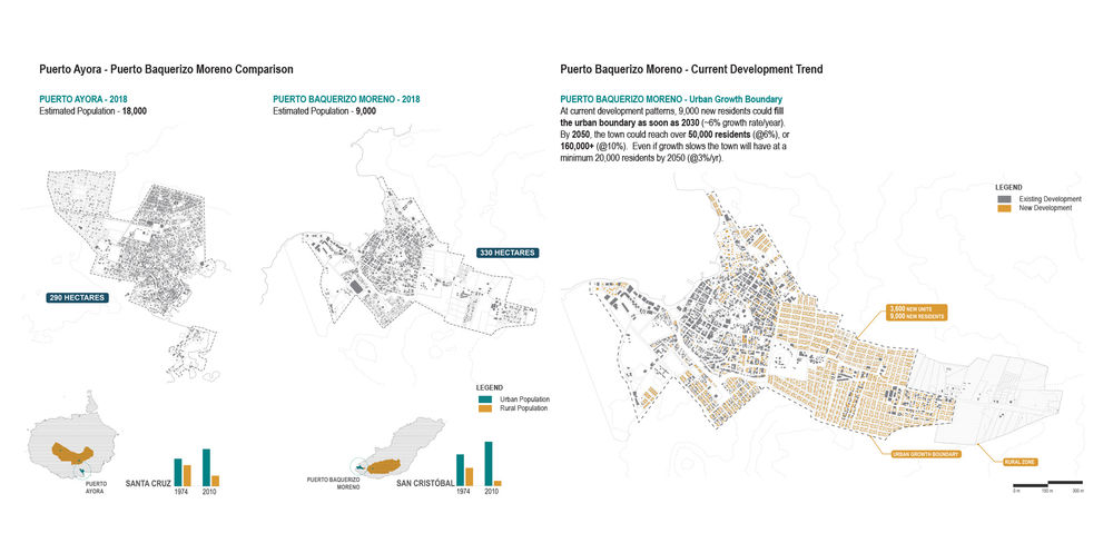
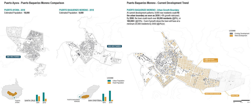
项目团队在圣克里斯托瓦尔岛上的工作主要集中在Puerto Baquerizo Moreno市内,这里拥有大约9000位居民。圣克里斯托瓦尔岛是唯一拥有淡水资源的岛屿,相比于大陆地区2%的人口年增长率,该岛的人口在近几年的年增长率已经超过6%,且预计将在10年内翻倍、15-20年内填满城市边界。这一状况将威胁到岛屿所依赖的生态资源,同时也会使居民面临洪水等一系列因地理环境造成的风险。在欠缺城市规划的条件下,圣克里斯托瓦尔很难制定出水资源(也是岛上最重要的资源)的保护策略。基于这一背景,项目团队制定了三项计划来解决以上问题,它们分别是:1.市区扩展;2. 地形测绘;3. 水样采集。
The Galápagos archipelago is one of the most important conservation sites in the world. 97% of its land is protected in the National Park and 95% of its native biodiversity is intact. However, the Galápagos is not just home to giant tortoises and blue-footed boobies – a rapidly growing population of ~34,000 people are concentrated on four of its thirteen islands.
Our work on San Cristóbal Island focuses predominantly on Puerto Baquerizo Moreno, a town of 9,000 residents. San Cristóbal is the only island with a fresh water source. At recent growth rates of over 6%/ year, compared to 2% on the mainland, San Cristóbal’s population will double in just over ten years, and could fill its urban boundary in 15-20 years. This would both threaten the ecological resources it relies upon while locating residents in precariously low-lying, flood prone locations. With little urban planning, San Cristóbal lacks a strategy for protecting its most vital resources: water. Our project addresses this gap through three strategic and ongoing parts: urban growth; topographic mapping; and water sampling.
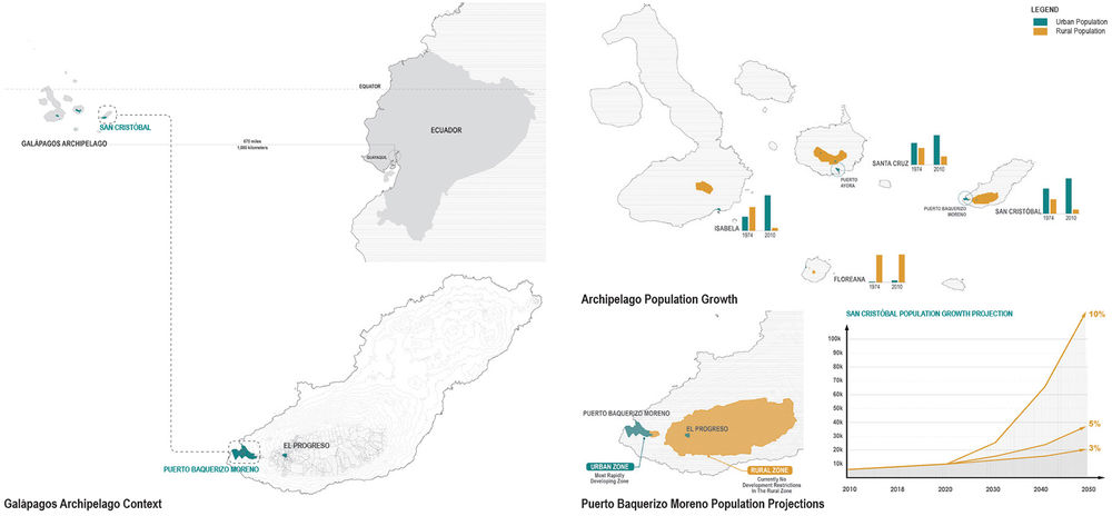
▲保护(城市增长):加拉帕戈斯群岛在1978年被列为联合国教科文组织世界遗产,为数百种特有物种提供了栖息的家园。然而,不论是相对原始的自然环境,还是岛上的人类居民,它们都面临着生存的挑战。Protecting (Urban Growth): Galápagos Context. Named a UNESCO World Heritage site in 1978, the Galápagos Islands are home to hundreds of endemic species. Yet this relatively pristine natural environment faces challenges, as do the island’s human inhabitants. © Dorothy Jacobs
在今天,约有3万4千人居住在加拉帕戈斯群岛的4个岛屿上,分别是圣克鲁斯岛(Santa Cruz)、圣克里斯托瓦尔岛(San Cristóbal)、伊莎贝拉岛(Isabela)和弗雷里安纳岛(Floreana)。人口的增长主要发生在过去的40年间,其原因是以“保护加拉帕戈斯群岛”为噱头的生态旅游市场的开发。该现象引发了所谓的“加拉帕戈斯悖论”:群岛被宣传为一个拥有原始生态的旅游地,从而导致了商品和游客的增长以及新物种的引入,并因此需要更多的人口来提供劳动力。反过来,游客带来的收入为国家公园的保护提供了资金,并且成为了岛上收入和就业的主要来源。1998年,岛上开始禁止移民(结婚移民除外),旅游业却并未受到限制,这对当地环境和居民均造成了不小的压力。同时,水需求的增长和建筑的急剧增加给岛上的水资源管理带来了重大的挑战,包括饮用水以及地形带来的问题(例如将水从高地引入低处的城镇)。
作为查尔斯·达尔文的第一个登陆点和群岛中人口第二多的岛屿,圣克里斯托瓦尔岛(本阶段工作的进行地)对于理解“一个位于海洋中央的孤立社区如何在维持良好的生活水平的同时保护生物多样性并适应气候变化”这一问题有着重要的作用。而令人惊讶的是,对于这个全世界被研究得最多且最重要的自然保护地,人们却很少去关注它的景观本身。
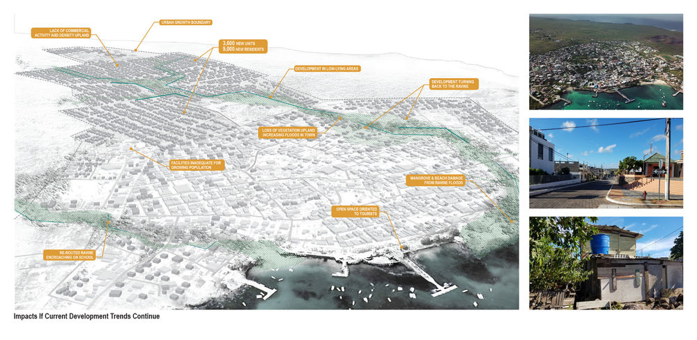
虽然加拉帕戈斯的自然环境受到了大量关注,但这种关注并未延伸至城市区域。这里几乎没有进行任何规划,居民的日常生活缺乏清洁的用水,且很少能够真正接触到令岛屿声名远扬的自然环境。城市持续地开发高地,却没有考虑地形和沟壑地带——它们对于从高地引入降雨有着非常重要的作用。继续增强对这些区域的开发将加重城区的洪涝问题,将人们置于危险的境地。此外,污水缺乏处理,被直接排放到海岸区域;泄露的污水管还可能成为饮用水的污染源。项目团队试图找出与城市水源相关的风险和机遇,主要的举措包括:研究地形,确定主要的水流区域;实施地形调查,找出准确的潮位,以便评估洪水与海平面上升及海啸之间的相关性。该项目涉及多方重要合作伙伴的参与,包括Puerto Baquerizo Moreno港的居民和学校、加拉帕戈斯国家公园、圣克里斯托瓦尔市长办公室、查尔斯·达尔文基金会以及海军海洋研究所(INOCAR)等。通过这项工作,我们希望使尽可能多的加拉帕戈斯民众对该项目有所了解,使其在获得保护自身健康的能力的同时,也学会保护这个他们赖以生存的独特而脆弱的家园。
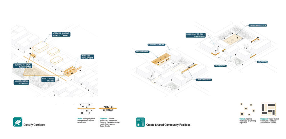
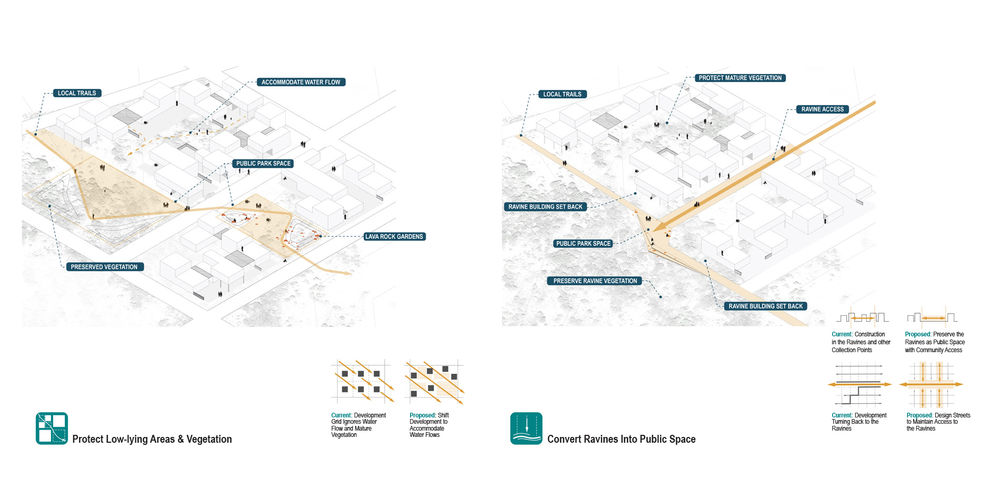
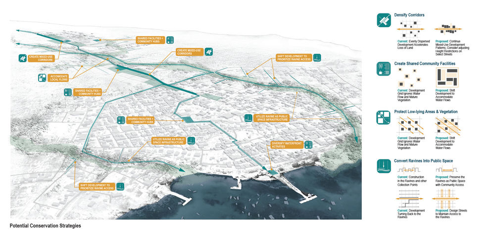
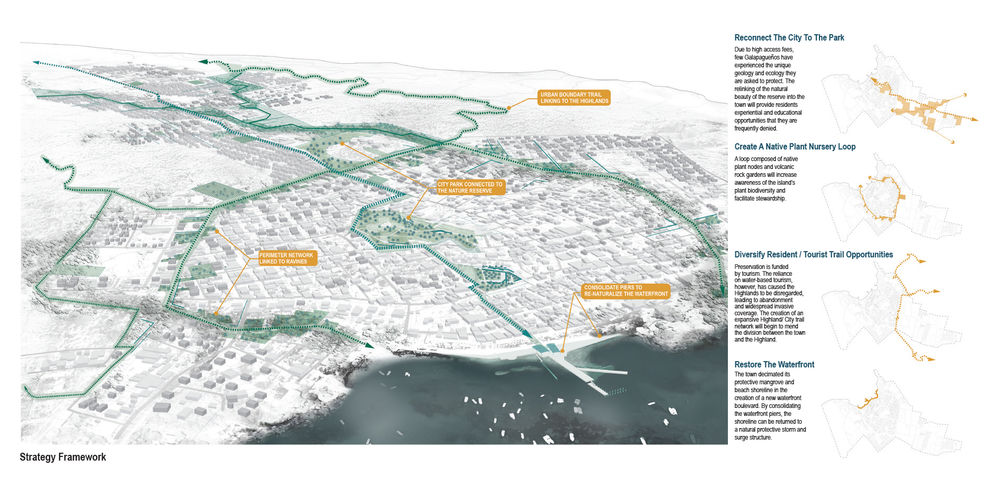
国家公园的保护工作并未作用到城市边界内部的地区,因而Puerto Baquerizo Moreno市的现有开放区域正在迅速地消失。我们的景观战略主要集中于尚未开发完善的地区,并强调以下四个原则:1)持续进行混合式的开发并提升高地区域的密度,遵循城市最古老的区域模式,而非采用如今盛行的“一地一房”模式;2)在被开发的街区内创造多用途的社区空间;3)适应既有的水流模式和重要的植被斑块;4)建立后退式的峡谷带,并将其构想为一个新的连接走廊,以便将国家公园的自然美景引入城市,从体验和生态两个方面来丰富迅速密集化的城市空间。我们希望居民与当地领导者都能够支持“开发区域与低地区域相关联”的策略,使这一景观框架成为重要的社会和与生态资源。
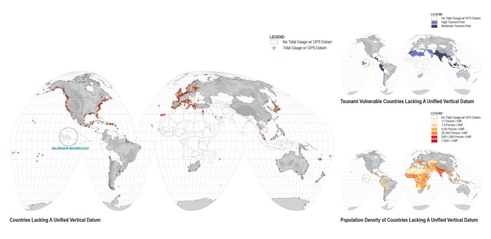
准确的调研和测量是景观分析、规划和管理的基础。然而,这一关键性的工作通常是雇佣测量人员或依靠已有的数据、地形图或公开的卫星图像来完成。尽管地球观测数据在近几十年间急剧增加,但实际上这些信息的分布并不均衡。更加令人惊讶的是,加拉帕戈斯群岛——这个全世界最具科学研究价值的区域——亦极为缺乏此类数据。如果没有一致且统一的高程基准,就难以准确地判断潮汐与陆地的相关性。当我们向INOCAR(厄瓜多尔海军海洋研究所,类似于美国的NOAA)求取相关信息以构建上述的城市增长框架时,他们却反过来需要我们协助其进行数据收集和测量标准的制定。
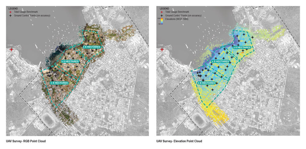
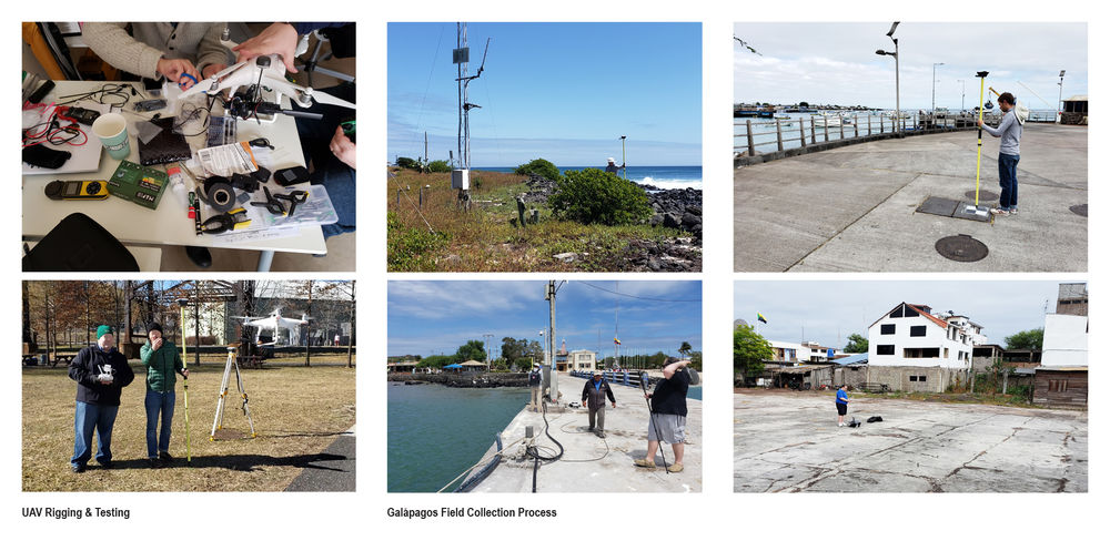
我们的团队利用非专门的UAV(无人机)和GPS/GNSS场地测量设备来记录Puerto Baquerizo Moreno的海岸线以及沟壑地带的航空测量信息。在为期四天的过程中,团队收集了约20公顷高精度、高分辨率的调查数据,包括检潮仪的位置和高程。在收集工作开始前,团队在整个城市区域设置了地面控制点(GCP),每个控制点均通过GPS/ GNSS测量设备记录下来,并以厘米级的精度测定出地理坐标上的确切位置。收集到的相互重叠的数字航空图像阵列通过摄影测量软件(Agisoft Metashape)进行拼接,以创建完整的海岸线拓扑模型。该模型于2019年秋季交付给INOCAR。以上信息对于模拟过去和未来的风暴潮、海平面上升以及海啸情境都有着至关重要的作用,因其关系到岛上的城区发展和野生动物的保护。
在INOCAR的协助下,团队于2020年夏季返回岛上,完成了对人口最多的Santa Cruz岛的其余两个检潮仪和海岸线的测量。
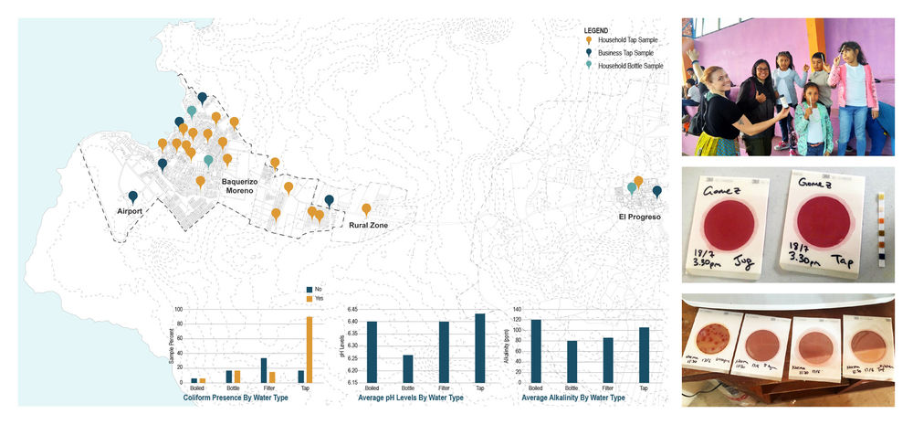
尽管圣克里斯托瓦尔岛的水已在当地工厂进行处理,但由于处理后发生的细菌污染(可能是蓄水池污染或污水管在输水管道附近泄露造成的),这些水无法达到饮用标准。为了缓解这一日益恶化的状况,项目团队发起了一项以社区为中心的服务“LAVA Aqua”,旨在监测圣克里斯托瓦尔岛的水质,同时让社区参与科学研究与教育工作。第一阶段是测试大肠菌群(不单指大肠杆菌)。团队在圣克里斯托瓦尔的查尔斯·达尔文基金会环境教育中心进行了关于水质测试和数据记录的科学方法的实践培训,让居民和中学生们可以通过简单的水质测试纸和大肠菌群实验汤来测试自己家中的自来水样本。接下来则是扩展样本数量和居民的参与规模。这些结果将被录入一个中央数据库并绘制成图,以开展确定全岛水质和污染模式的工作。这些数据对了解水质对于城市发展、人口增长和季节性降雨的影响有着至关重要的作用。通过该项目,我们希望鼓励圣克里斯托瓦尔的各个社区都能主动检测它们自己的用水。
▲保护(城市增长):人口与发展趋势。加拉帕戈斯群岛有97%的土地受到保护。圣克里斯托瓦尔岛是人口第二多的岛屿,按照近几年6%的人口年增长率,该岛的人口预计将在10年内翻倍,并在15-20年内填满城市边界。Protecting (Urban Growth): Population & Development Trends. 97% of the archipelago is protected from development. At recent growth rates of 6% per year, San Cristóbal, the second most populous island, will double its population in just ten years and could fill its urban boundary in 15-20 years. © Dorothy Jacobs
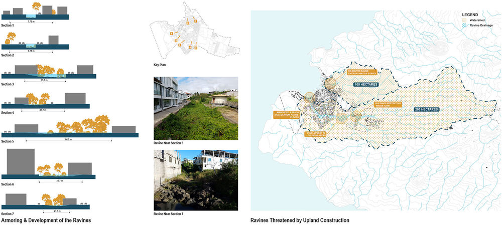
▲保护(城市增长):保护沟壑地带。为了解决城市的发展问题,项目团队首先分析了既有的地形、沟壑和分水岭。这既是了解雨水从高地流向何处的关键一步,又是整个设计方案的基础所在。Protecting (Urban Growth): Safeguarding the Ravines. To address the town’s growth, our team began by analyzing the existing topography, ravines, and watershed. This was a critical first task for understanding where rain flows from the highlands, and formed the basis for our design recommendations. © Keith VanDerSys

▲保护(城市增长): 继续当下趋势对城市发展的影响。由于缺乏规划,Puerto Baquerizo Moreno市的开放区域正在迅速消失。这种碎片化的开发过程忽略了对地形的考虑,这将加剧城市的洪水问题,使人们处于危险之中。Protecting (Urban Growth): Development Impacts if Trends Continue. Due to the lack of planning, the existing open areas of Puerto Baquerizo Moreno are disappearing quickly. This piecemeal development process is happening without regard to topography, which will exacerbate town flooding and put people in harm’s way. © Dorothy Jacobs
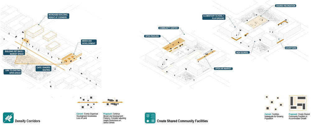
▲保护(城市增长): 保护策略。随着城市的持续扩展,低地的地形应当得到保护。要维护这些开放区域,就需要使其他区域密集化。具体的实现方法是放宽特定区域的高度限制,并重新设计“楼对地”的配置,以形成共享的户外空间。Protecting (Urban Growth): Conservation Strategies. As growth continues, low-lying topography should be protected. Maintaining these open areas will require densifying other areas, which can be achieved through loosening height restrictions in select areas, and designing building-to-lot configurations that result in shared outdoor spaces. © Dorothy Jacobs
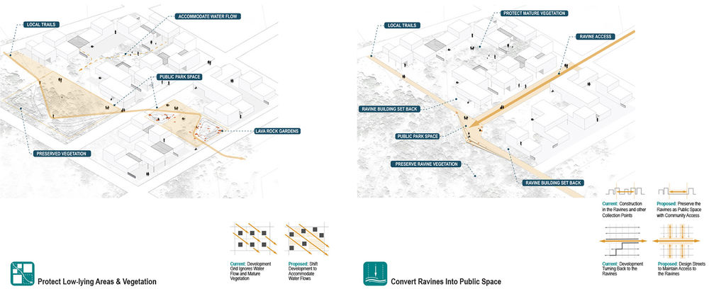
▲保护(城市增长): 保护策略。沟壑带是一种常常被忽视的社会和生态资源。为了发挥出沟壑带的重要功能,需要对建筑进行后退式处理,并调整地块和街道组织。Protecting (Urban Growth): Conservation Strategies. The ravines are an overlooked social and ecological resource. In order to prioritize their importance, building setbacks and adjustments to lot and street organization are needed. © Dorothy Jacobs
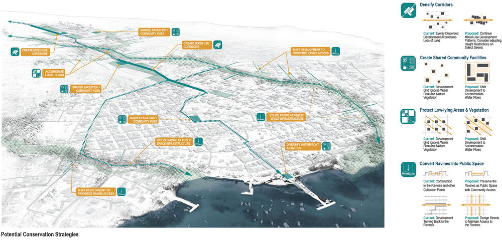
▲保护(城市增长): 景观框架。随着人口的增长和城市的扩大,4个主要的保护策略(已在前两张图纸中概括)将被逐步且灵活地实施。Protecting (Urban Growth): Landscape Framework.The four principal conservation strategies (outlined in the previous two drawings) can be used incrementally and flexibly as population grows and the town expands. © Dorothy Jacobs
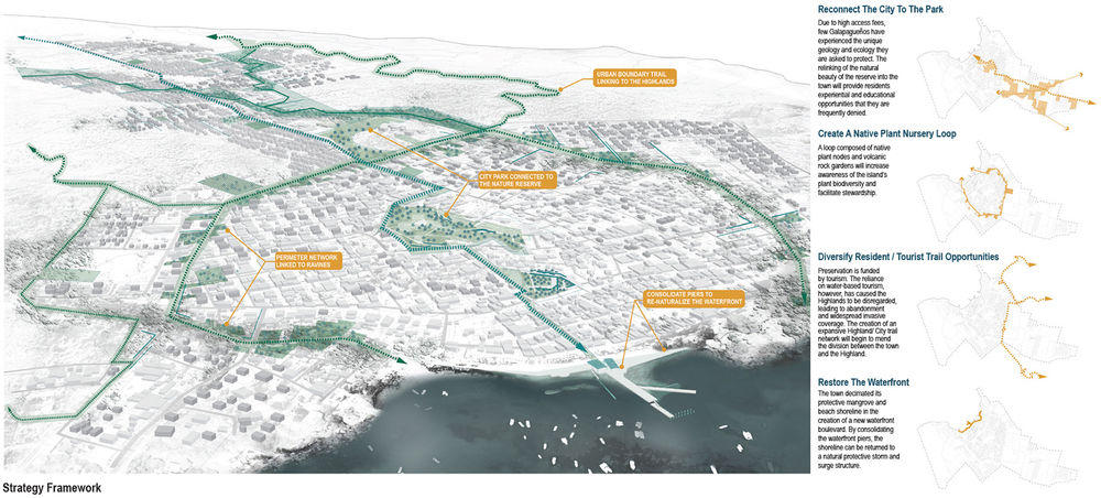
▲保护(城市增长): 创造连接。项目将通过一个连接城市景观节点和国家公园的公共空间框架来为居民提供此前未有过的多样化的路径和体验。该框架同时还突出了岛上独特的火山地形。Protecting (Urban Growth): Creating Connections. A public space framework that connects the landscape-oriented nodes in town with the broader national park, and highlights the unique volcanic terrain, will provide residents with a diversity of access and experiences that is not currently available to them. © Dorothy Jacobs
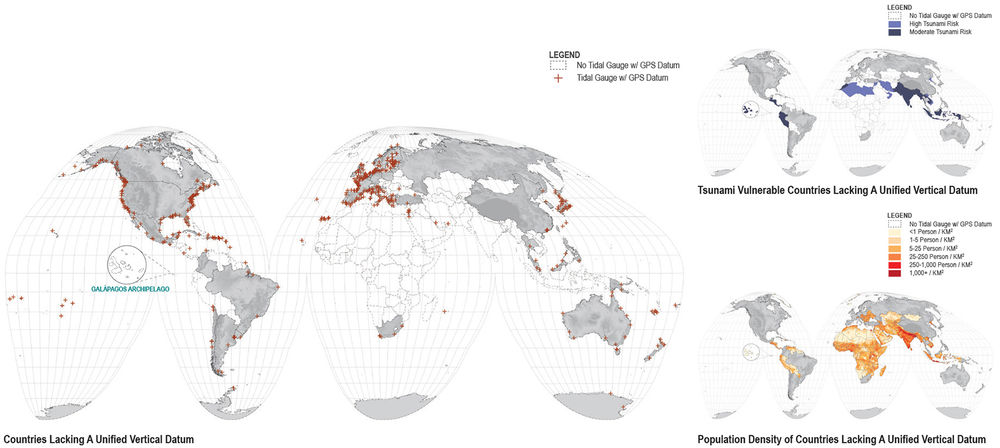
▲测量(地形测绘):全球水数据。全球有大量区域缺乏能够帮助测量和预测相对陆地的水位高度的基本数据。更令人惊讶的是,加拉帕戈斯群岛——这个全世界最具科学研究价值的区域——亦极为缺乏此类数据。Measuring (Topographic Mapping): Global Water Datums. Vast stretches of the Earth lack the basic data to measure and predict water elevations relative to land. Surprisingly, the Galápagos Islands—one of the most scientifically studied sites in the world—lacks such data. © Keith VanDerSys

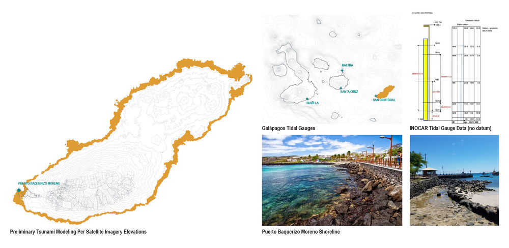
▲测量(地形测绘):圣克里斯托瓦尔检潮仪。群岛的检潮仪缺乏一个统一的高程基准,在没有此基准的情况下就无法准确地判断潮汐与陆地的相关性。Measuring (Topographic Mapping): San Cristóbal Tidal Gauge. The archipelagos’ tidal gauges lack a unified vertical datum. Without a consistent and unified vertical datum, tides cannot be accurately referenced to the land. © Keith VanDerSys

▲测量(地形测绘):无人机测量。项目团队利用非专门的UAV(无人机)和GPS/GNSS场地测量设备来记录Puerto Baquerizo Moreno的海岸线以及沟壑地带的航空测量信息。Measuring (Topographic Mapping): UAV Survey. Our team used off-the-shelf UAVs (drones) and GPS/ GNSS site survey equipment to record aerial survey information of Puerto Baquerizo Moreno’s shoreline and ravines. © Keith VanDerSys
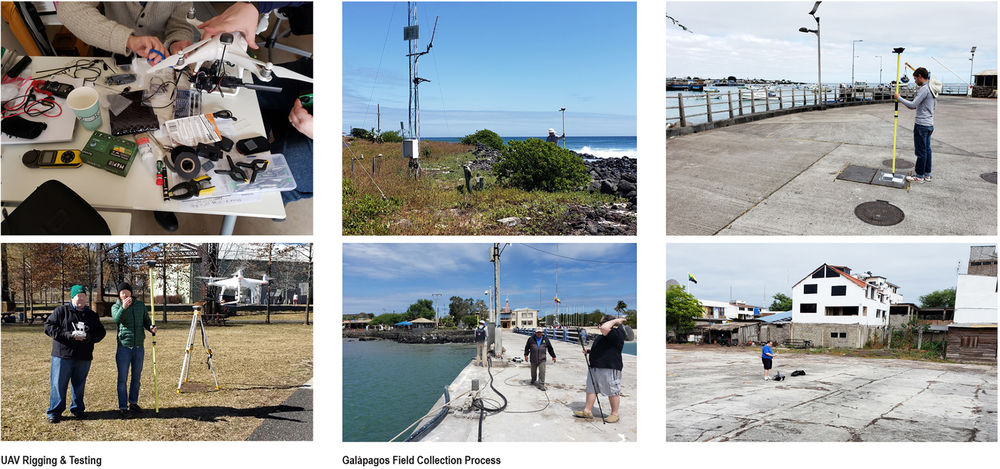
▲测量(地形测绘):收集过程。在为其4天的收集过程中,团队收集到大约20公顷高精度、高分辨率的测量数据,包括检潮仪的位置和高程。Measuring (Topographic Mapping): Collection Process. Over the course of a four-day collection period, our team collected approximately 20 hectares of high accuracy, high resolution survey data, including the tide gauge location and elevation. © Keith VanDerSys
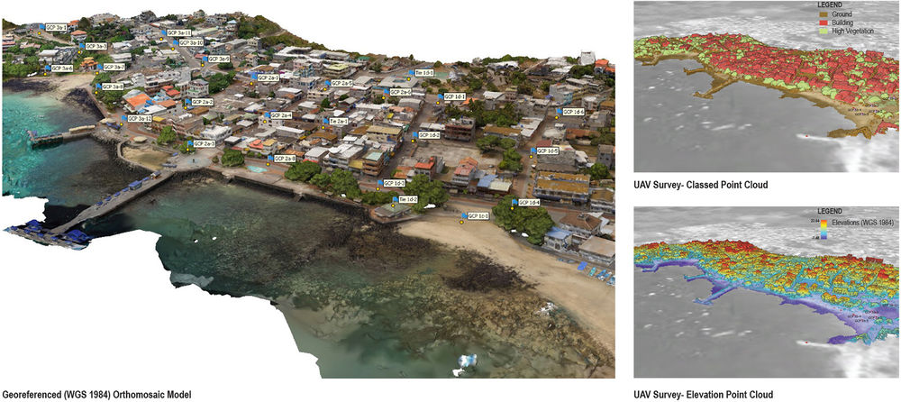
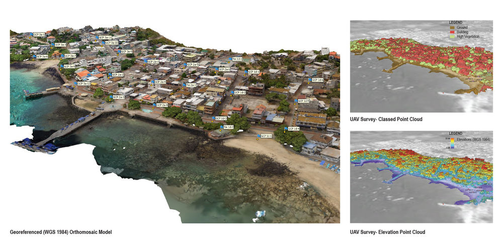
▲测量(地形测绘):正射影像模型。通过调查工作,现可对相对于陆地的潮汐高程进行测量。借助这些数据,厄瓜多尔海军海洋研究所(INOCAR)将能够更加准确地评估和分析过去与未来的潮汐和风暴。Measuring (Topographic Mapping): Orthomosaic Model. Through our survey work, tidal elevations can now be measured relative to land. This will enable The Oceanographic Institute of the Navy in Ecuador (INOCAR) to more accurately assess past and future tides and storms. © Keith VanDerSys
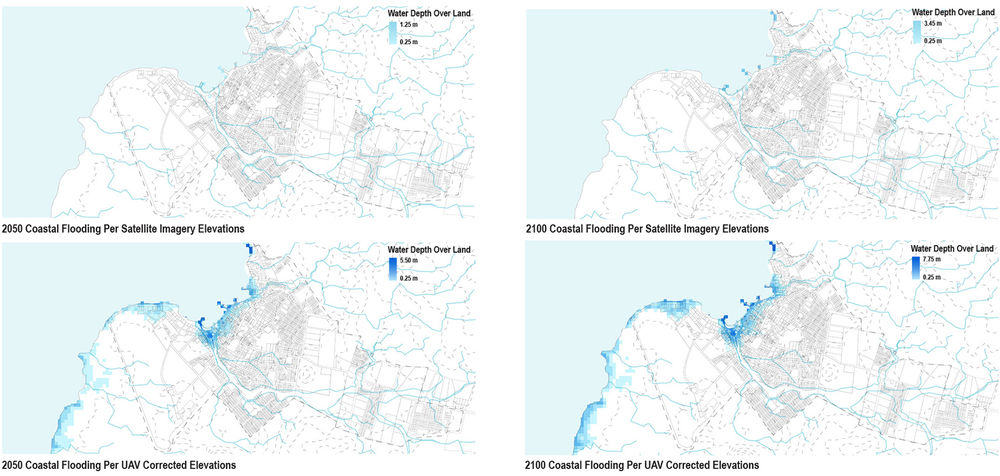
▲测量(地形测绘):经过重新计算的洪水水位。圣克里斯托瓦尔的地形高度目前是通过卫星图像来计算的。虽然这对于预估海平面上升来说是必要的,但由这种方法得出的高度并不准确。在利用高精度的高程数据进行校正之后发现,圣克里斯托瓦尔未来所面临的洪水风险要比原先的预测要高出许多。Measuring (Topographic Mapping): Recalculated Flood Levels. The height of San Cristóbal’s terrain is presently calculated through satellite imagery. Though imperative for estimating sea level rise, the elevations derived from this method are inaccurate. When corrected with our high accuracy elevation data, future flood threats are much higher on San Cristóbal then previously understood. © Keith VanDerSys
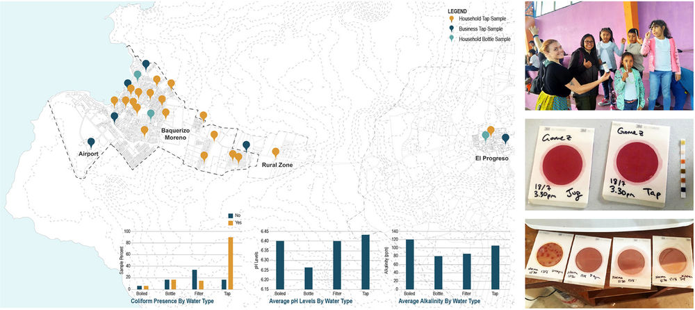
▲测量(水取样):社区取样。圣克里斯托瓦尔岛的水没有达到饮用标准。项目团队鼓励居民参与到城市重要水资源的采样和监测工作当中。居民们收集到的数据对于了解发展、人口增长和季节性降雨如何影响水质有着至关重要的作用。San Cristóbal’s water is not potable. Our team engaged residents to participate in sampling and monitoring the town’s most vital resource. Data gathered by the residents will be critical for understanding how development, population growth, and seasonal rainfall affect water quality. © Michael Weisberg
Today, there are roughly 34,000 residents living on four islands (Santa Cruz, San Cristóbal, Isabela, Floreana). Most growth has occurred in the last forty years due to the creation of a market for ecotourism as a means to “preserve” the Galápagos. This has resulted in what is referred to as the “Galápagos Paradox.” The islands are promoted as a pristine place to visit, thereby increasing the flow of goods and tourists, which introduces new species and requires an increasing population to supply labor. Conversely, tourist-generated revenue provides funding to protect and maintain the national park, and is the primary source of income and employment. Immigration to the islands (other than through marriage) was banned in 1998, while tourism has not been successfully limited even though the pressures on the local environment and people originate from developing the Galápagos as a tourism destination. As a consequence, water demand and building have increased dramatically, causing major challenges in water management, both in terms of drinking water and in terms of topography (i.e. water flow from the highlands into the lower-lying towns).
As the famed site of Charles Darwin’s first landing spot and the second most populous island, San Cristóbal (where this phase of our work takes place) plays an important role in understanding how an isolated community in the middle of the ocean can sustain a good standard of living while protecting biodiversity and adapting to climate change. It is surprising that in one of the most scientifically studied and important nature sites in the world, there is little attention to the landscape itself.
The enormous amount of attention given to the natural environment of the Galápagos has not been extended to the urban areas. There is little to no planning and residents suffer from lack of clean water and limited access to the nature for which the islands are famous. The town continues to develop upland without consideration of the topography and ravines, which are critical for rainfall flowing from the highlands. Increased development into these zones will exacerbate town flooding and put people in harm’s way. They also have limited sewage treatment, and are discharging directly into the beach areas; leaking sewage pipes are possibly a source of drinking water contamination. Our team set out to address the risks and opportunities related to the town’s water. This process included: studying the topography for identifying major water flow areas; a topographic survey to accurately determine tide levels and thereby evaluate flooding vulnerabilities related to sea level rise/tsunamis; and testing drinking water to benchmark water quality. This projected included the participation of many key partners including residents and schools in Puerto Baquerizo Moreno, the Galapagos National Park, the Mayor’s office of San Cristóbal, the Charles Darwin Foundation, and the Oceanographic Institute of the Navy (INOCAR). Through this work, we hope to inform as many Galapagueños as possible so that they can be empowered to protect their health, and the health of the unique and fragile place that they call home.
Protecting (Urban Growth)The protection efforts in the National Park are not applied to areas within the urban boundary. Thus, the existing open areas of Puerto Baquerizo Moreno are disappearing quickly. Our landscape strategy concentrated primarily on the yet to be developed areas, and emphasized four principles: 1) continuing mixed development and more density upland, which follows the pattern of the oldest areas of town, rather than a “single house on a lot” model that is now prevalent; 2) the creation of multi-use community spaces within development blocks; 3) accommodating existing water flow patterns and significant vegetation patches; 4) establishing a ravine set back and envisioning it as a new connective corridor that will bring the natural beauty of the national park into the town, thus experientially and ecologically enriching the quickly densifying town. Our hope is for residents and local leaders to support a strategy for directing development away from low-lying areas and use this landscape framework as a vital social and ecological resource.
Accurate surveys are foundational to the analysis, planning, and management of landscapes. As a discipline, we have normally outsourced this crucial component of the planning process by hiring surveyors or relying on existing surveys, topographic maps, or publicly available satellite imagery. While Earth observation data has increased dramatically in the last few decades, this information is not equally distributed. Surprisingly, the Galápagos Islands—one of the most scientifically studied sites in the world—lacks such data. Without a consistent and unified vertical datum, tides cannot be accurately referenced to the land. When we reached out to INOCAR (The Oceanographic Institute of the Navy in Ecuador, similar to the USA’s NOAA) to request this information for developing the urban growth framework described above, they instead asked for our assistance in the collection and registration of the gauge.
Our team used off-the-shelf UAVs (drones) and GPS/ GNSS site survey equipment to record aerial survey information of Puerto Baquerizo Moreno’s shoreline and ravines. Over the course of a four-day collection period, our team collected approximately 20 hectares of high accuracy, high resolution survey data, including the tide gauge location and elevation. Ground control points (GCP) were distributed throughout the town before the collection periods. Each GCP was recorded with the GPS/ GNSS survey equipment to locate its exact location in geographic coordinates at centimeter-level accuracy. The array of overlapping digital aerial imagery collected was stitched together using photogrammetry software (Agisoft Metashape) and used to create a complete topo-bathy model of the shoreline. This model was delivered to INOCAR in the fall 2019. This information will be essential for modeling both past and future storm surge, sea-level rise, and tsunami scenarios as it relates to the island’s urban growth and wildlife conservation.
Our team, with assistance from INOCAR, will return this summer to complete the surveying of the remaining two tide gauges and shoreline on the most populous island (Santa Cruz).
Despite undergoing treatment at a local plant, San Cristóbal’s water is not potable due to bacterial contamination that is occurring post-treatment, perhaps due to cistern contamination or sewage pipes leaking into the ground near the water distribution pipes. In order to mitigate worsening conditions for residents, our team initiated a community-based outreach—LAVA (Laboratroio para la Vida y el Ambiente) Aqua—which aims to monitor water quality in San Cristóbal while engaging the community in scientific research and education. The first phase tested for coliform generally (not e. coli specifically). Using simple water quality test strips and coliform test broth, our team began hands-on training on proper scientific techniques for testing and recording water quality data at the Charles Darwin Foundation’s Center for Environmental Education in San Cristóbal. With the team’s assistance, residents and middle-school children took samples of tap water in their homes and businesses. Next steps will involve protocols for getting larger numbers of samples and residents involved. The results will be added to a central database and mapped to begin to identify patterns in water quality and contamination across the island. This data will be critical for understanding the affects to water quality related to development, population growth, and seasonal rainfall. With this project, we hope to encourage the communities on San Cristóbal to take initiative in monitoring their own water.

