苏密古城重生 | 考古遗址公园总体规划
中国城市建设研究院有限公司分享了他们在2018年IFLA非洲、亚太、中东地区分析与规划类竞赛中获得荣誉奖的作品——苏密古城考古遗址公园总体规划: CCUD shared their works of IFLA 2018 AAPME analysis and master planning award honorable mention——the Master Plan for Sumi Archaeological Site Park:
基地位于寒冷的中国吉林省桦甸市,在唐代,这里也是渤海国苏密城址所在地,与唐王朝在整治、经济、文化上有着密切的交流。苏密古城,是营州道上迄今唯一经考古确认的府治行政单位,属国家级重点文物保护单位。
The project is located in Huadian, a cold city in Jilin Province, China. In Tang Dynasty, it was the site of the ancient city of Sumi, Bohai which interacted with Tang Dynasty closely in politics, economy and culture. As the only site of prefectural government on the Yingzhou Road confirmed by archaeological discovery, the ancient city of Sumi is one of national key historical monuments under special preservation. Nowadays, its site is the only evidence available confirming Bohai State.
▼遗址航拍,sumi heritage
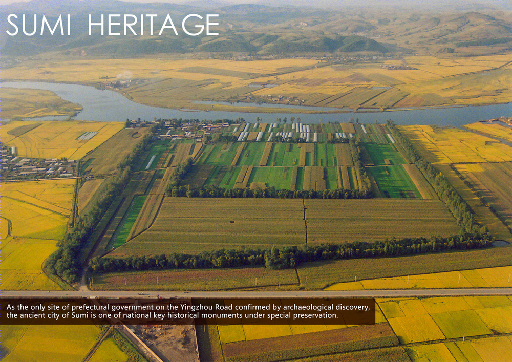
苏密古城始建于公元820年左右,随着一千多年的后续建设,城址呈现内外双城墙的独特空间结构,城垣外侧分布有两道护城壕。外城是中国境内首座经系统考古工作确认的渤海府州故址,内城是首座经考古工作发现确认的东丹国城址。遗址对渤海、契丹文化及其相互的关系研究具有极为重要的学术意义。
The ancient city of Sumi had a construction history of more than 1,000 years that can be traced back to 820 AD. The site is characterized by its unique spatial structure, which consists of inner and outer city walls defended by two parallel trenches. The outer one is the earliest prefectural site of Bohai State in China which is confirmed after a series of systematically archaeological work. The inner one is the earliest confirmed city site of Dongdan State. The site is of academic significance in the study of Bohai and Khitday culture and their mutual relationship.
▼基地分析,site analysis

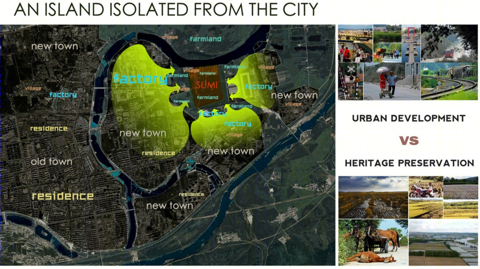
铁路、高压线、地下采矿、工厂的修建与遗址争夺空间。村民将水系的截断,进行水稻田生产灌溉,遗址周边的自然山水环境被破坏。遗址与城市之间关系变得僵硬,逐渐成为城市边缘的孤岛。
Railways, high-voltage lines, factories and underground mining are competing for space with the site. Villagers redirect the water course to irrigate rice fields. Both the industrial development and agricultural production are worsening the natural environment around the site, making it an island isolated from the city.
▼城市孤岛,city island
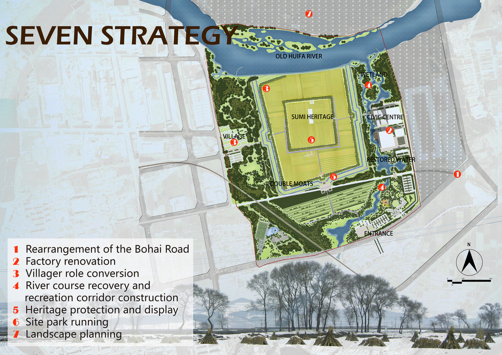
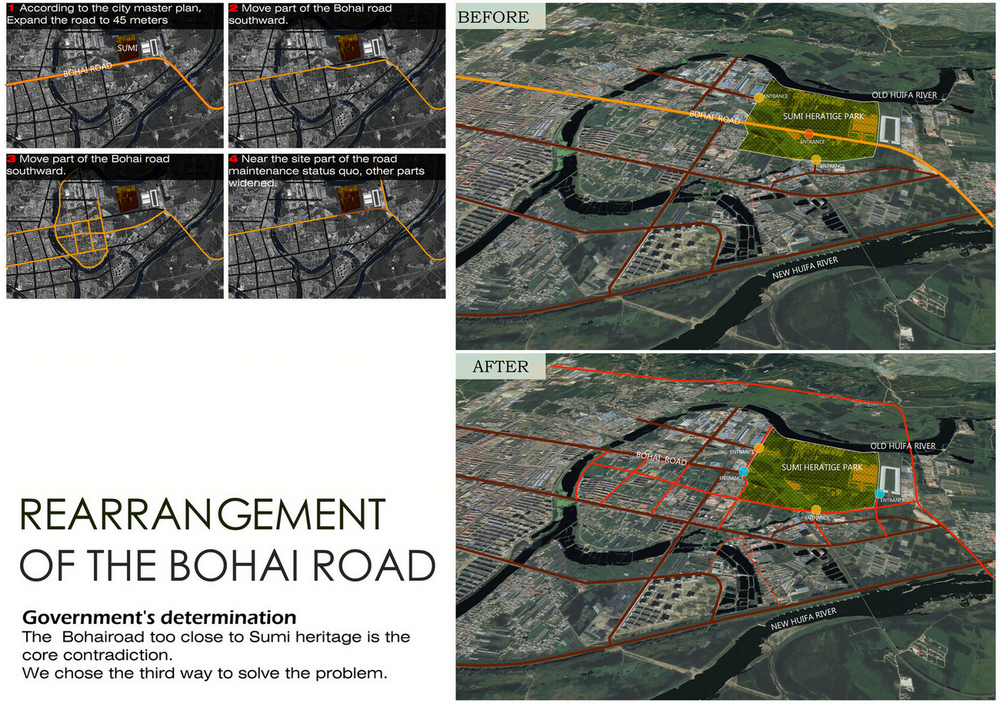
渤海大道和遗址之间的距离过近是本次公园规划的核心矛盾。经过与政府的多次沟通,渤海大道南移的方案获得政府的大力支持,以降低对遗址的干扰。通过一小段新的道路的建立,将南侧村庄与公园之间产生直接连通,增加遗址与南侧新城之间的联系。近期,渤海大道维持现状,远期作为公园内部道路使用。
Our plan to rearrange the Bohai Road southward has gained strong support of the government after constant communication. A short new road, to be built between the park and villages along its south side, is expected to bridge the park with the southern newly-built urban area. The Bohai Road remains what it is before it is used as the park’s internal road in the future.
▼渤海大街改线,change the bohai road
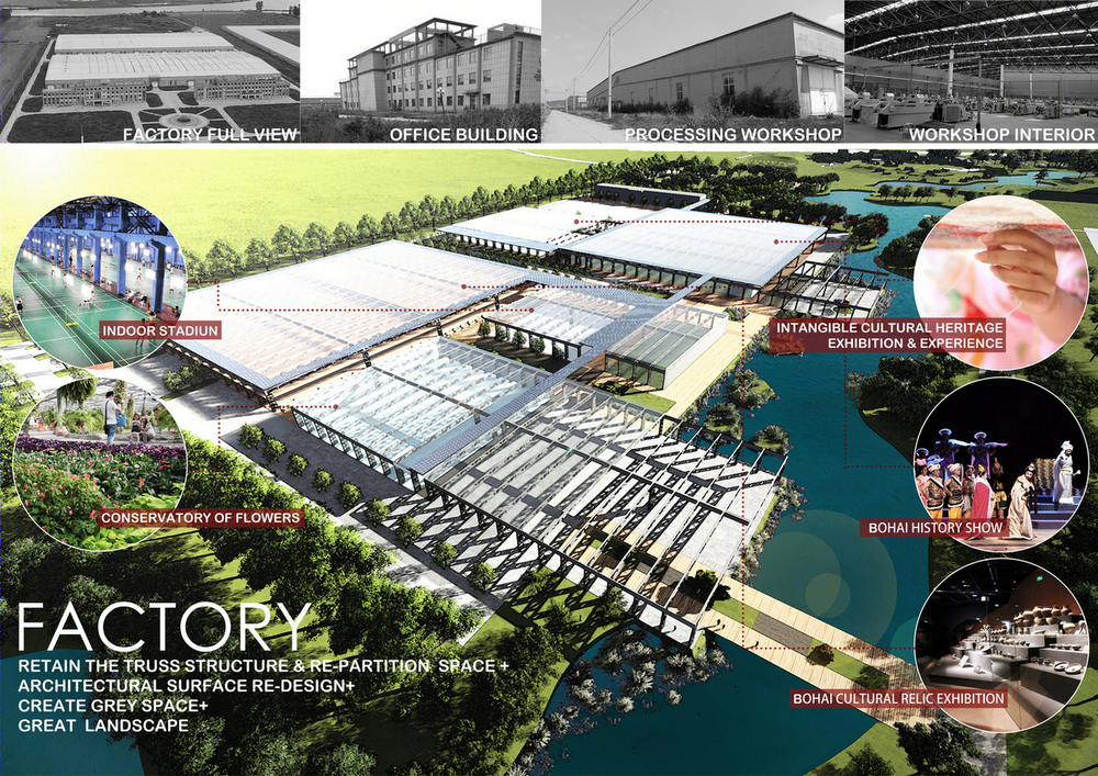
工厂建成于2009年,2015年倒闭后,荒废至今。本次规划采用部分保留与改造的策略,将厂房改造成遗址博物馆、展览馆、市民文体活动中心和温室花房。遗址公园成为城市功能的重要组成部分。并且该城市一年之中降雪长达6个月,改造工厂作为重要的室内活动场所,成为市民进行集体活动的温暖场所。
According to the planning strategy of preservation and renovation, part of the buildings are to be converted into a museum, an exhibition hall, a recreation center and a greenhouse. As indoor places are more favorable to local climate than outer ones, they will bring conveniences for residents who have to endure the 6-month-long winter. The rest part of them is to be demolished and new buildings are not allowed around the site.
▼工厂的转变,factory renovation
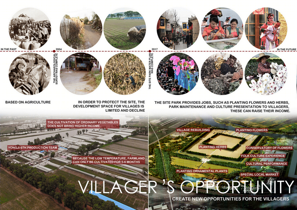
共有200位村民生活在遗址公园内。他们以蔬菜种植作为主要的收入来源。本次规划将村民的收入结构从单一的农业作物种植,扩展到公园维护、小商品售卖、展示演出、售票等多种途径。收入的增加极大提高了村民保护遗址的积极性。
Two hundred villagerslive in the northwest of the site. The income sources of villagers will be multiplied, not being confined to single vegetable production but including park maintenance, performances, sales of tickets and souvenirs, etc. Their site-preserving interest grows with increasing income.
▼村民的转变,villagers opportunity
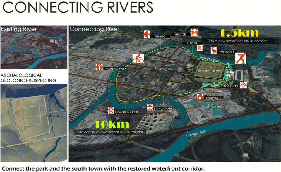
通过考古勘探,在遗址东侧和南侧分布有原有河道。本次规划对原有河道进行恢复,将辉发河与辉发河故道连接起来,形成城市东侧的10km环形连续生态休闲廊道。恢复的河道在南侧新城和辉发河故道之间提供了一个1.5km的滨水生态路径,串联工厂改造区,有利于将人气引入公园北侧。
Archaeological exploration shows that there are old river courses on the east and south side of the site. We plan to recover the old courses and connect Huifa River with the Huifa old river course, thus establishing a 10-kilometer continuous circle ecological recreation corridor in the east of the city. A 1.5-kilometer-long water-front ecological trail between the southern new urban area and Huifa old river course is built through the recovered river courses. It ties the reconstruction area of factories and attracts visitors to come to the north side of the site park.
▼水系恢复,connecting rivers
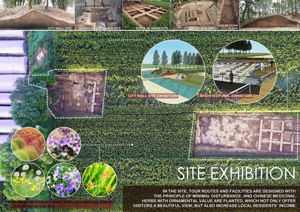
在遗址范围内,出于保护的角度,采用乡土地被种植的分区设计手法,结合微地形的设计,标记遗址的不同组成部分、展示遗址的重要节点。公园内广泛种植具有经济价值的地被植物和各色中草药,村民对其进行很好的管理以保证作物的收成,同时为公园提供整洁有序的视觉效果。
According to the micro-topographical features, we adopt partition design of local groundcover plants for site protection. distinct parts and important nodes of the site are marked out. The park is widely planted with economically valuable groundcover plants and various Chinese medicinal herbs which are well managed by villagers to ensure the harvest. Meanwhile, they are parts of the clean and orderly scenery.
▼遗址展示,heritage display
在公园的规划过程中,由政府和村民共同形成的经营组织得到双方的支持,负责公园维护、配套服务、经济生产、经济分配、文化展示等工作。
The running board formed by the government and the villagers get support from both sides. It is responsible for the maintenance of the park, related service, agriculture production, income distribution, culture exhibition and so on.
▼遗址公园鸟瞰,landscape pattern
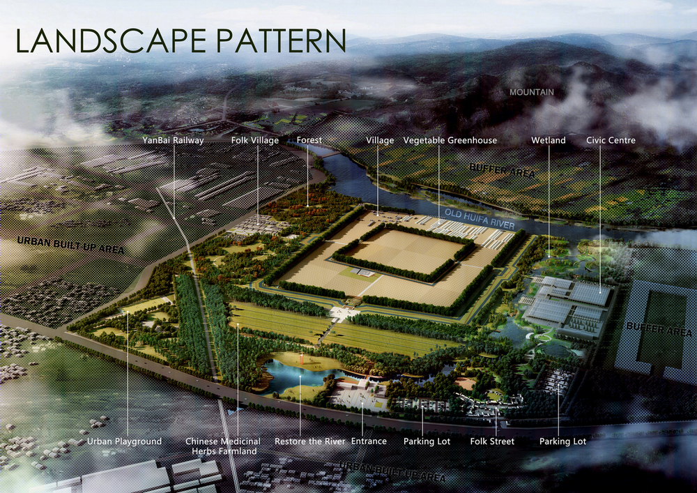
在公园范围外,设立遗址保护缓冲区,控制建设力度,以保证遗址周边自然山水城市格局。
In order to ease over-building and preserve the original landscape, a buffer zone outside the park is included in the plan.
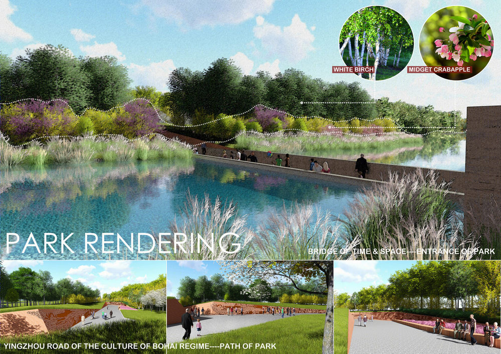
▼遗址效果,park rendering
▼总平面,site plan
