垂直领土 | 绿色环保的未来城市示范区
“我们可以说,景观设计师的终生目标和工作就是帮助人类。使人,建筑物,社区,城市以及他们的生活,同生活的地球和谐相处。”
学生奖的第四集是通用设计荣誉奖 Vertical Territories 来自中国的景观设计师陈忱Chenchen,之外还有E. Scott Mitchell, Amy Whitesides. 这是他们在哈佛大学GSD学习期间的设计作业。
垂直领土将南Weymouth Naval海军空航站点重建为开放式生产性用地。通过分层的方式,避免损害广袤的地表,在不同的功能密度层上促进替代能源创新,栖息地的保护,暴雨管理,以及淡水资源管理。项目采取技术和养护将以前无联系的比邻城市中心联系,成为可以提基础设施服务的景观—–一种城市规划原型。
该美军退役海军基地位于波士顿南侧15公里处,位于三镇Abington, Rockland 和Weymouth,Massachusetts的交汇要赛。大家都知道,这里被海军在1940年买下这片1500亩湿地和林地用作军事基地,生产直升机的构件。自从1997年退役以来,这里的发展得到许多建议,首当其冲的就是清理现场有毒物质。
关于这片场地有很多建议,比如复杂的电影工作室,住宅区,零售商业区。这些建议不会改变当地经济下滑的现状,而修建住宅也缺乏公共空间和水资源。一些经济因素被优先考虑,忽略了野生动物保护,公共健康,安全和环境生产力等等更大的问题。因此设计师建议将这里作为一个城市发展下的区域资源,这里是开放空间,为公共健康服务,保护和补充淡水资源,提供重要的暴雨管理,保护野生动物,并作为一个高新风力发电技术试验经济区。通过垂直空间以实现这些目标,采用分型面,表面和超级表面产生能量,进行雨水管理,维护公共空间和野生动物栖息地。分层的方法可以不影响广阔的地面景观,并能成为城镇衰退经济的推进力。
项目的核心建议是一个新兴的高海拔风力发电技术(飞行风力发电机)。高行风是创新的替代能源之一,生产率高,成本低。这里的东北区域上空的高行风可以成全这个理想的实验,也许能让项目在世界上成为第一个此类大规模区域能源发电区。
传统风力发电的涡轮是引起候鸟死亡的重要原因,而这个设想没有大面积暴露的叶片,将减少这种危险。这里可以为马萨诸塞州的濒危鸟类提供栖息地,比如:Bobolink, Upland Sandpiper, GrasshopperSparrow, Barn Owl, Snowy Owl, American Kestrel, American Bittern, 和King Rail.场地声场的植物也可以为飞跃北大西洋的候鸟作为停留点。这与那些作为住宅和商业开发的用地完全保顿。这里是一个包含栖息地,能为地区经济带来推进作用的试验场。
高海拔涡轮机在地面上有一个固定系绳点,避免了大型基础,只占用很少的地面,为生态和文化预留了更多的土地。这就是垂直领土,空中有实验,地面有鸟类栖息地,洪水滞留地和生态管理系统。
场地也位于三条流域的交叉口,最后水流汇入波士顿湾。其中两条经过场地,这两条水系属于季节性水系,因为以前管理不善,时而爆发洪水,时而缺水,同时淡水还需海水淡化厂填补,已耗资7000万美元。场地通过地下储水,减轻洪水和缺水的力度,同时形成湿地,滞留暴雨雨水。这些湿地向公众开放,路径穿插其中并与邻里城镇相连。
通过水管理获得高地下水位有助于实现湿地和草原栖息地。纵观整个现场的土地,把握用地敏感性,在西部建立湿地用以收集和处理雨水。相比之前高成本的做法,这种通过生态环境,植物处理手法的成本经济。
场地成为三个城镇间具备活力的开放空间,满足城镇的娱乐需求,资源需求,基础设施需求,还提供了面,衍生面,超级表面的土地利用总体规划新典范。这样的新型垂直用地能为城市中心发展过程中提供重要的水资源,自然资源。
Project Statement
Vertical Territories proposes the redevelopment of South Weymouth Naval Air Station as productive open space. It promotes alternative energy innovation, habitat preservation, floodwater management and freshwater conservation through a layered approach that allows for functional density without compromising the expansive quality of the ground plane. The project uses technology and conservation to stitch together adjacent but disconnected urban centers and serves as a prototype for urban planning that recognizes the critical infrastructural services landscape provides.
Vertical Territories proposes a redevelopment strategy for South Weymouth Naval Air Station, a decommissioned US Naval base approximately 15 miles South of Boston, located at the convergence of three towns; Abington, Rockland and Weymouth, Massachusetts. Known as SOWEY, the air base was purchased by the military in 1940 and transformed from 1500 acres of marsh and woodlands into one of the only naval bases in the US to house fixed-wing propeller, jet, helicopter, and lighter than air craft simultaneously. It was decommissioned in 1997 and has since been the site of numerous development proposals. The most recent of which is currently on hold due to public debate and the need for cleanup of toxic areas on site.
Highly contested plans for its redevelopment currently include a movie studio complex, retail shops and a planned residential community. The proposed plans for SOWEY do not address the region’s declining economic conditions, the existing excess of residential land, the lack of public open space or the current water shortages and the pressure the development would place on these resources. Current proposals view the site as an economic resource for a few businesses. Larger issues of wildlife conservation, public health and safety and environmental productivity are ignored. In contrast, our proposal considers the site a regional resource and a potential prototype for urban development that places a premium on the environmental and public health services of open land overlooked by typical urban expansions such as those proposed.
In contrast, we envision SOWEY as a public space that protects and replenishes freshwater resources, provides important flood control services, conserves habitat for endangered species, and serves as a testing ground for emergent high altitude wind generation technologies that could serve as an economic resource for the region. The project spatially achieves these goals through utilization of vertical territory, taking advantage of sub- surface, surface and super-surface to generate energy, manage storm water and enhance public open space and wildlife habitat. The layered approach allows for density of function without compromising the expansive open quality of the ground plane and allows a once gated ‘backyard’ to towns in economic decline to become a generator of vital resources.
At the core of this proposal is the implementation of a testing area for emergent high altitude wind generation technologies, or flying electric generators, (FEGs). High altitude winds have recently been identified by innovators in the alternative energy industry to have the potential to produce significantly greater energy at far lower cost than traditional wind turbines. SOWEY, along with much of the Northeast, lies beneath an area of consistent high altitude winds. These winds make the site an ideal location for testing of emergent high altitude wind technologies and possibly one of the first sites for large scale deployment of FEGs as regional energy generators.
Compared to traditional wind turbines, FEGs offer a number of benefits that are important to their implementation at SOWEY. Traditional turbines are known to be a cause of death for migrating birds. The lack of large, exposed rotating blades as well as the increased height at which FEGs operate significantly reduces the danger of bird-turbine interactions. This is significant for the development at SOWEY because the site currently serves as habitat for a number of Massachusetts’ endangered bird species including the Bobolink, Upland Sandpiper, Grasshopper Sparrow, Barn Owl, Snowy Owl, American Kestrel, American Bittern, and the King Rail. In addition, many other wetland and grassland species utilize the site as a stopping point on the North Atlantic Flyway. Implementation of a traditional turbine strategy or a large residential and commercial development would be at odds with the conservation of critical habitat for these species. Development of the site as a testing ground preserves habitat while still allowing the ground at SOWEY to operate in an economically productive manner for the region.
In addition, the high altitude turbines require only a single tether point on the ground, compared to the large foundations of traditional turbines. The implementation of an FEG test site therefore takes up very little ground space, freeing the ground plane to be utilized for other ecologic and cultural services. Vertical Territories takes advantage of this fact and combines the aerial FEG strategy and avian preserve with a wetland floodwater detention and management system on the ground.
The Naval Air Station is located at the intersection of three watersheds, all of which drain into the Boston Harbor. Two creeks run through the site, French’s Stream, which drains to the Southeast and Old Swamp River which drains to the Northeast. These streams are both ‘gaining streams’ meaning they exchange water with the large aquifer upon which the site is situated. Both of these streams flood regularly, causing damage to homes and property downstream from the Naval Station. Flooding occurred as recently as spring of 2010, when statewide flood events cost the state $100 million dollars. Despite regular flooding events, the towns surrounding SOWEY, like many in Eastern Massachusetts, suffer from regular water shortages due to contamination and improper management of water resources. These shortages have led to the building of a desalination plant in nearby Brockton which cost the state $70 million dollars. Vertical Territories seeks to alleviate these water shortages and the intensity of flood events through making water from the aquifer below the site available for public usage while replenishing its resources through a series of wetlands that aid in storm water management and rainwater retention. These wetlands are made accessible to the public via a set of paved and non-paved pathways that tie in to the adjacent neighborhood. Taking their cues from existing roadway structure, these paths make connectivity between the three towns that once backed onto SOWEY possible.
The strategy for implementation of the proposed wetland and grassland habitat depends greatly on the management of onsite streams and the high water table that contributes to them. The water table at SOWEY has been fluctuating in response to the varied land uses on site throughout its history. The proposed site operations are orchestrated so as to take advantage of this sensitivity. Initial grading of French’s stream diminishes the amount of water it takes from the aquifer. Selective deforestation limits evapotranspiration where desired and allows for the creation of wetlands along the Western border of the site that collect and treat rainwater. The wetlands are designed with differing permeability and smoothness based on their relationship to the location of the aquifer and existing contamination, the cleanliness of the water they collect and functional requirements such as oxygenation. Maintenance of grassland and successional vegetation as well as occasional dredging of sedimentation in the wetlands will be a part the ongoing maintenance regime on site. These are relatively low cost measures compared to costs of flooding and water shortages currently experienced.
The project operates at the site level to develop what was once a remnant piece of land between three towns into a vibrant open space that connects the towns while serving recreational, resource production and infrastructural needs. In addition, it offers a new paradigm in land-use planning based on an understanding of sub-surface, surface and super- surface conditions. Vertical Territories creates a new typology of productive open space that connects once disparate urban centers while protecting regional water resources and recognizing the important services natural resources can provide if made central in the process of planning for urban development.

总平:设计师将这里作为一个开放空间进行雨水管理,保护野生动物,并作为一个高新风力发电技术试验经济区。将以前无联系的比邻城市中心联系,让公众可以方便到访。
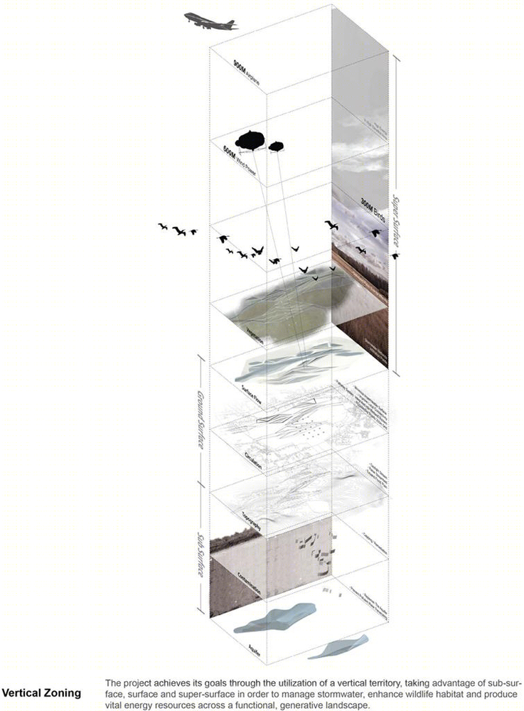
垂直分区:通过分层的方式,用不同类型面,面和超级表面进行雨水管理,野生动物栖息地的保护以及多功能景观能源资源生产地。
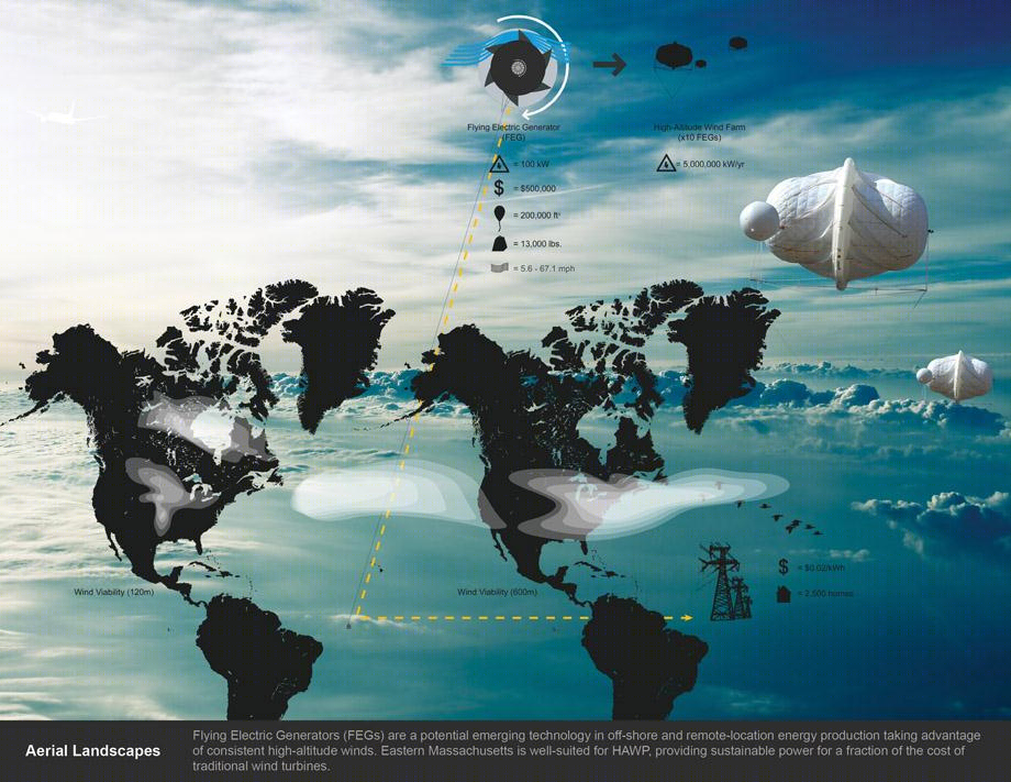
空中景观:飞行发电机是一个潜在的新兴技术,利用高行风产生能源,成本是传统涡轮机的一小部分,却能产生强劲能源。
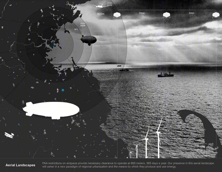
空中景观:因为美国联邦航空局的限制,空中发电机高度在任何时候不能超过600米。这种景观可以迎来一个城市化能源生产和利用的新模式。
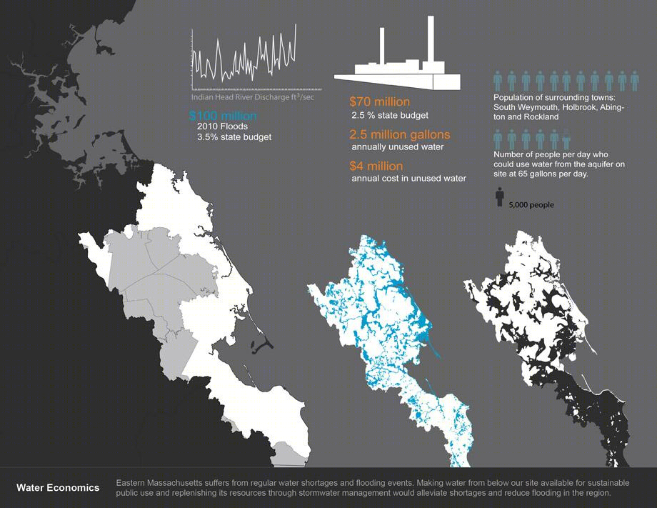
水管理:这里经常缺水会被淹。可以通过场地进行雨水管理环节上述情况。
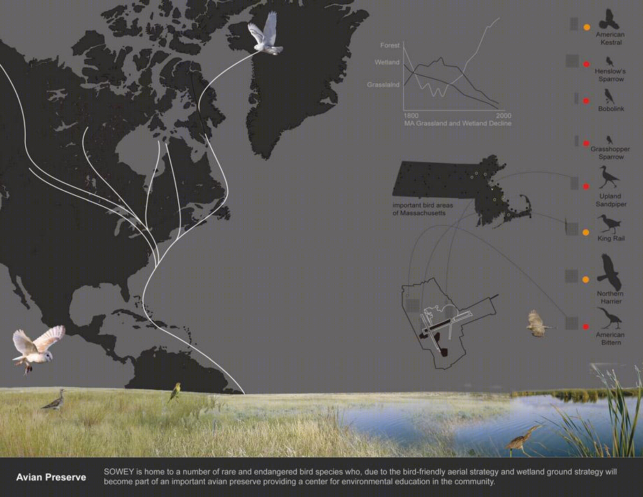
鸟类保护:这里可以作为鸟类特别是候鸟的栖息地,提高濒危鸟类数量,同时成为环境教育的典范。
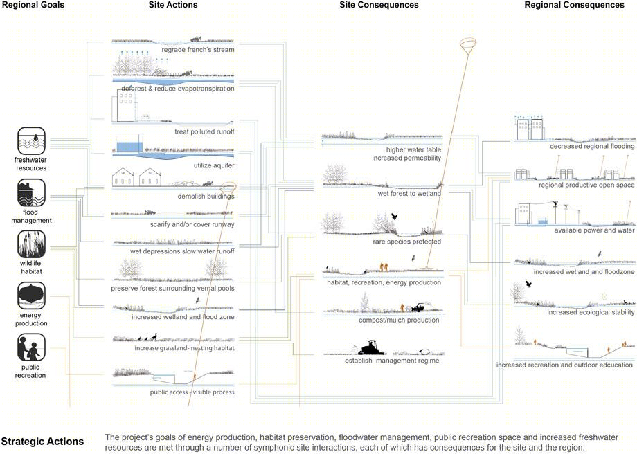
战略行动:目标是将能源的生产,栖息地的保护,洪水管理,公共休闲空间,淡水储备等等建立成为相互影响且可以控制结果的互动体系。
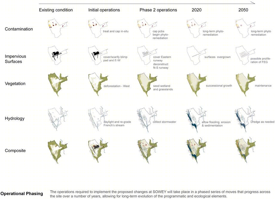
管理调整:在场地分时间阶段的进行修整,并允许长期生态演进方案。
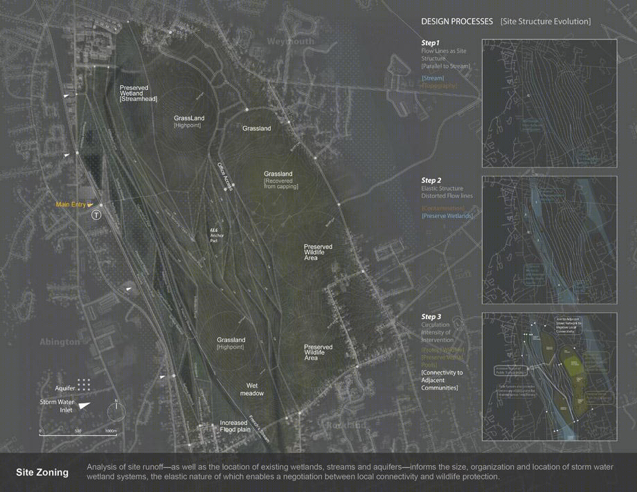
场地区域:湿地,水系,地下储水层的位置以及它们的可容纳的变化性,保证场地满足人类的可达性与野生动物的保护。
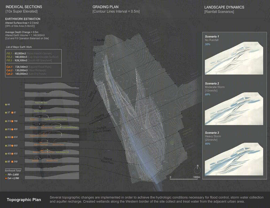
高程图:变化的地形满足了防洪储水,雨水收集和补给的条件。主要在西侧创立湿地收集雨水。
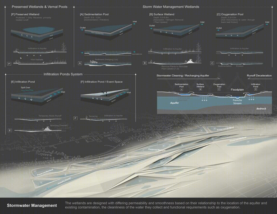
雨水管理:通过湿地将污水变得洁净。
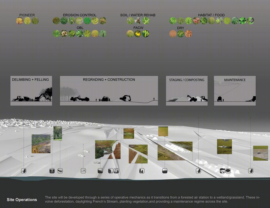
场地运营:经过一些列改造,场地回复森林,湿地,草地。每天场地进行新的种植,以确保整个空间的运转。
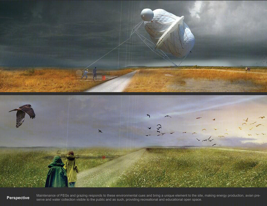
透视:飞行发电机是环境一道独特风景,同时确保能源再生,保护鸟类,为雨水收集和休闲教育提供了开放空间。
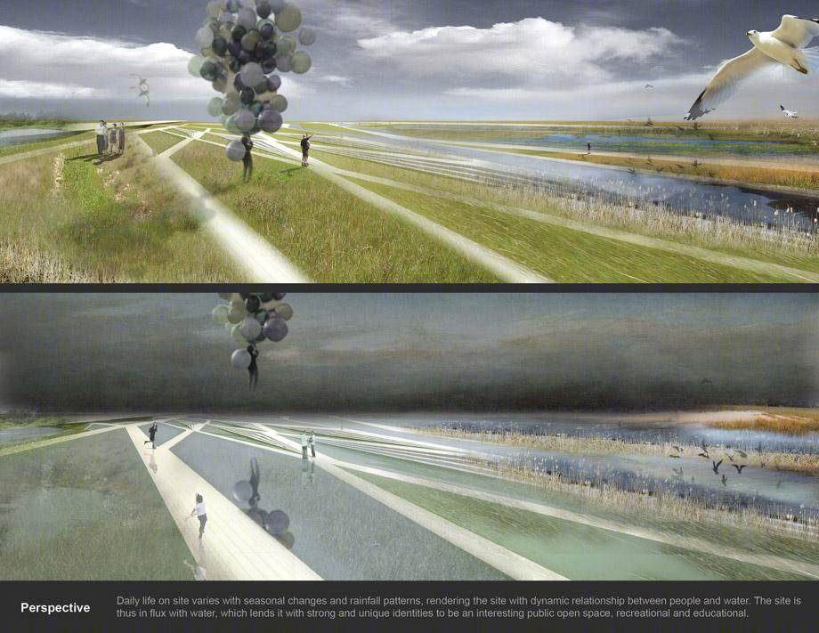
透视:不同季节和降雨情况,场地中水和人的相互关系。场地与水息息相关。因此这个场地独一无二,是有趣的休闲,保健,教育场所之地。
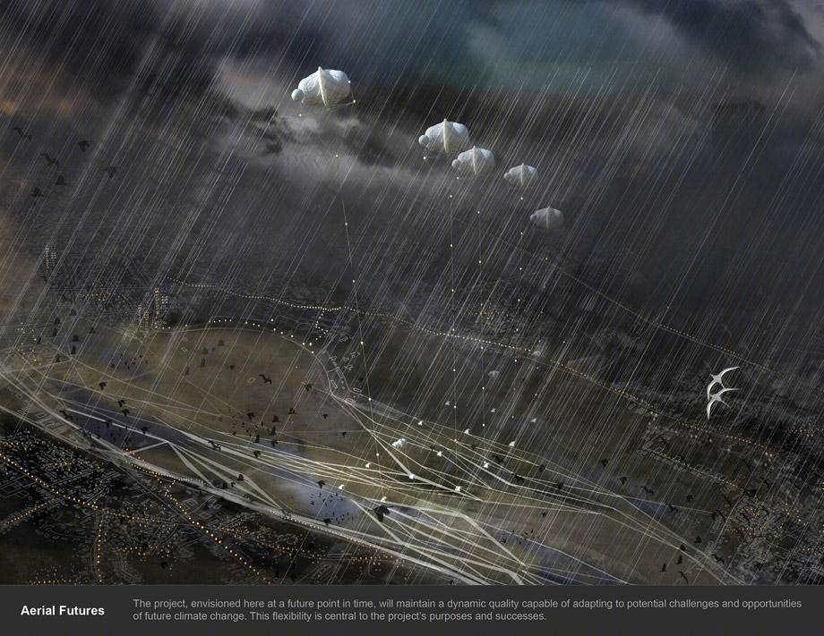
项目在未来的某个时间点会达到一种动态的平衡适应未来的气候变化以及挑战和机会。这种灵活性是项目的追求以及成功的核心。
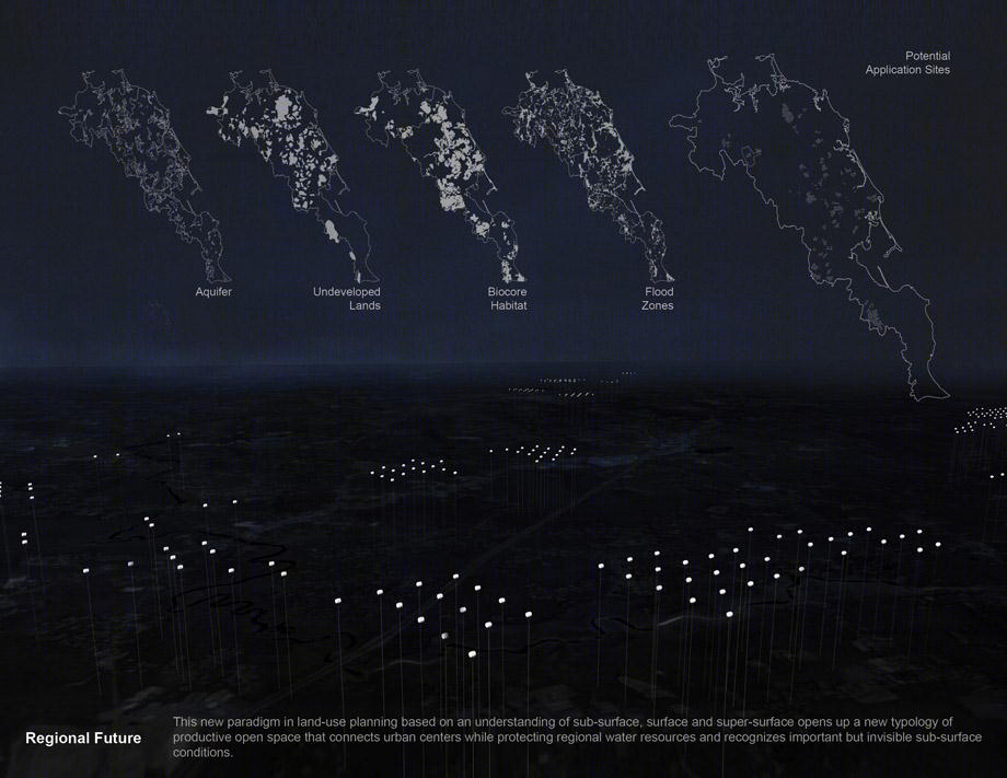
区域未来:一个土地利用新模式–类型面,面,超级表面开辟的新垂直土地,联系城市,提供水资源保护,保证地貌完整性。
MORE:
陈忱
Chenchen
,更多请至:


