融合自然与历史的阿尔巴尼亚海岸线开发规划
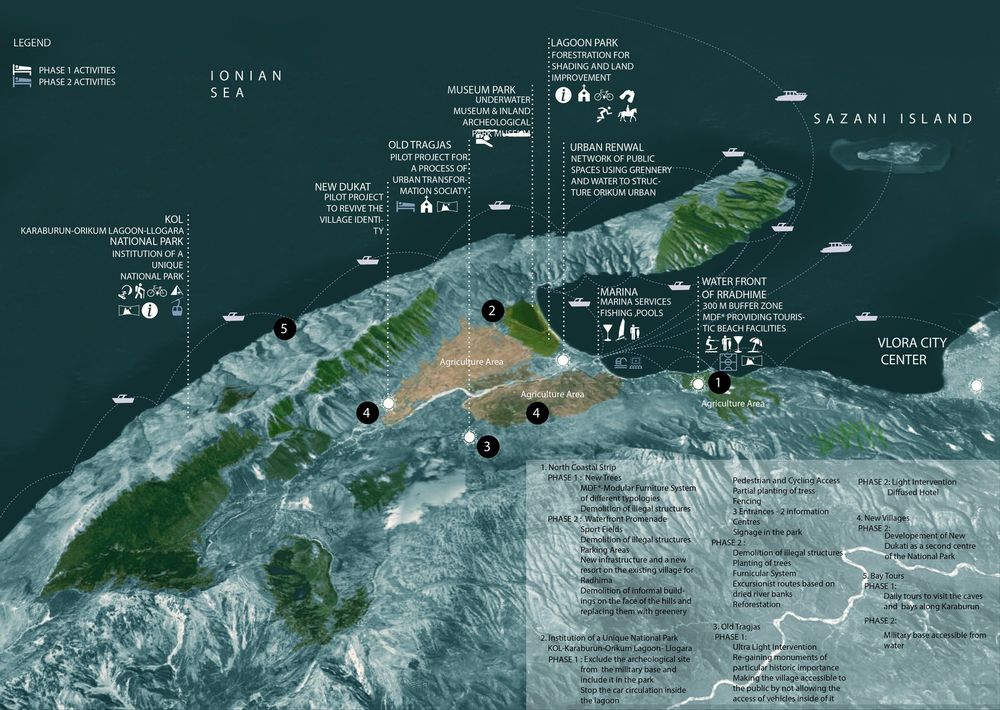
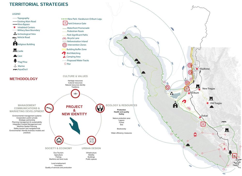
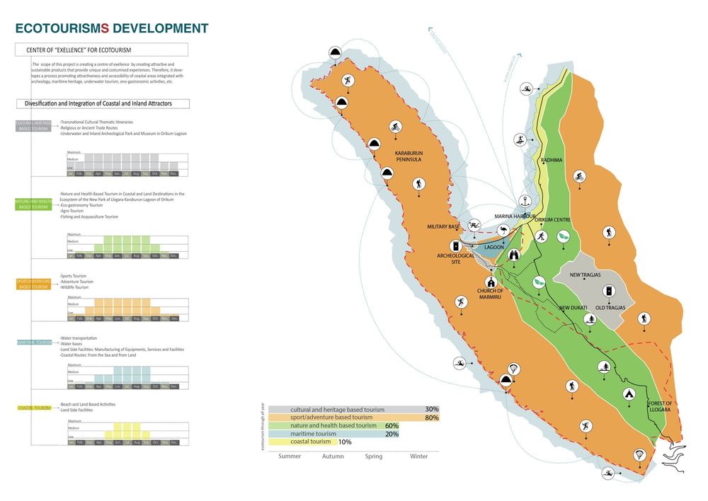


[EN] The project consist in a masterplan for the touristic development and for the urban design for public spaces and services for the Coast Strip and Surrounding Villages for the Orikum Region. The project institute the National Park of Llogara-Karaburun-Orikum Lagoon with the scope of this project is creating a Centre of Exellence by creating attractive and sustainable products that provide unique and costumised experiences. In order to reache this aimit’s proposed a process able to promote attractiveness and accessibility of coastal areas integrated with archeology, maritime heritage, underwater tourism, eno-gastronomic activities, etc
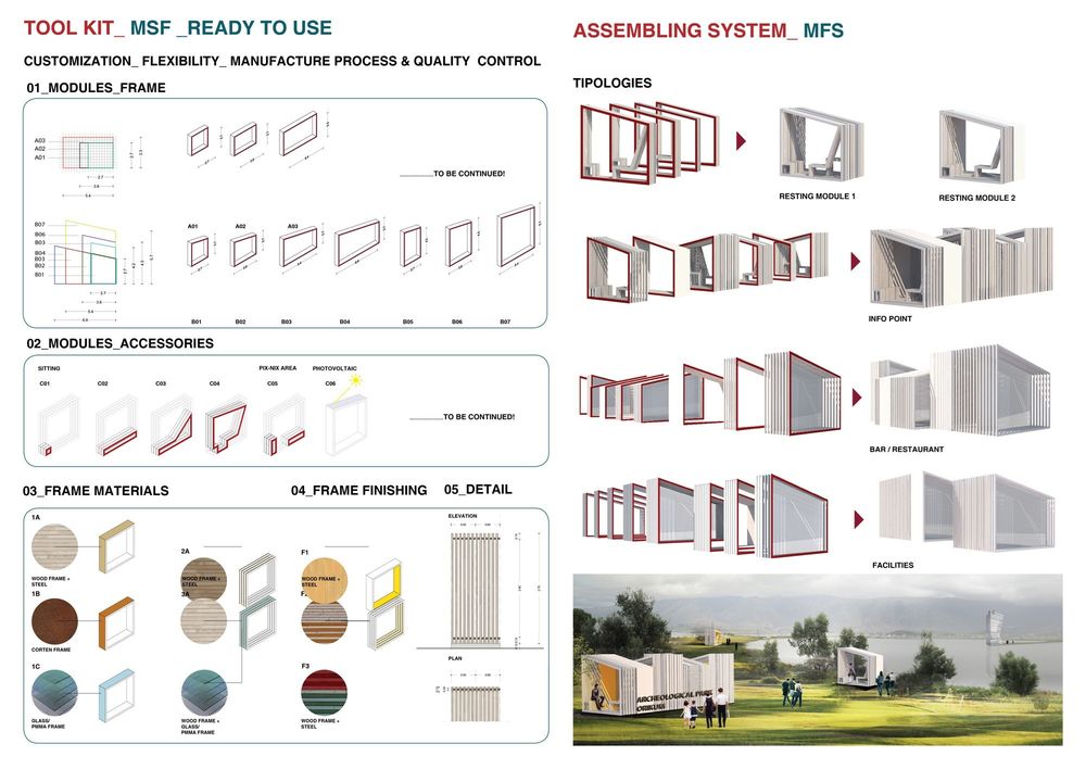
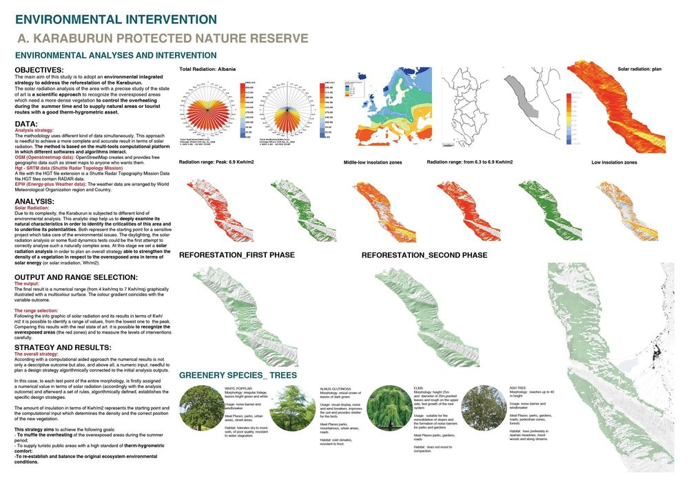
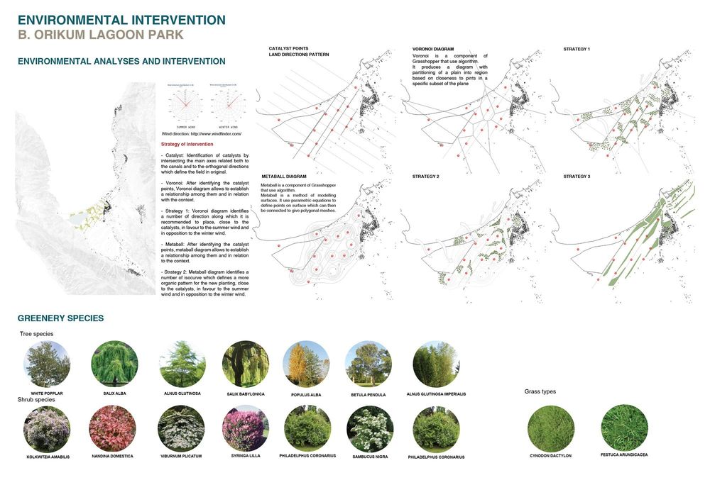
The Institution of the National Park Llogara+Karaburun+Orikum Lagoon with a clear boundary, protection buffer zone in the boundary of the park predicting the enlargement of the area and including the wetland areas, the church of Marmiru and the archaeological zone. The park will be equipped with a visitor centre in the lagoon area and a modular furniture system as a support for multiple activities (MFS Modular Furniture System). The existing the coastal street next to Orikum that cut the natural connection between the lagoon and the sea will be located behind the wetland area, along the boundary of the first cultivated fields, and connected with the military base and the existing paths of Karaburun. The Reserve of Karaburun, where for years there were the practice of burning the pastures, is interested by a plan of reforestation necessary for improving the comfort of the area. The recognizability of the Park is supported by creating a brand for the Park: a new logo, a name (K.O.L for Karaburun-Orikum-Llogara), that will sign every path and every focal point.
In addition to the enhancement of existing naturalistic value, the project proposes the identification of archaeological paths able to reconnect Old Trajas and other historic and archaeological sites within the network of values of the region of Orikum. The project proposes the conversion of the village of Old Trajas in a Diffused hotel and the restoration and conservation of historic buildings of the city of Rradhima.
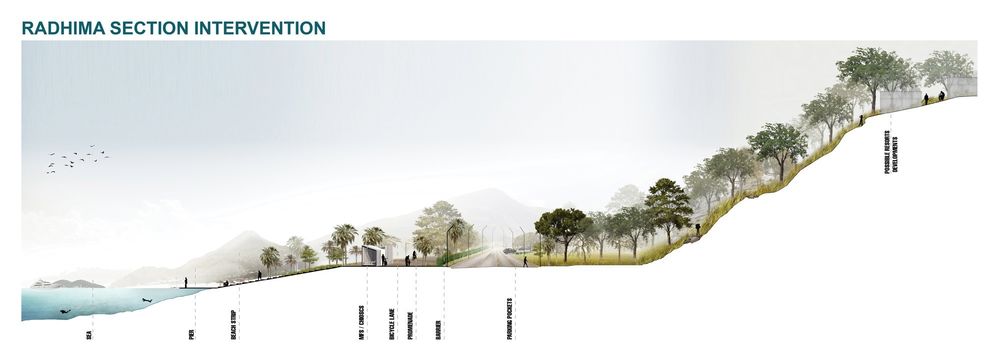
For the North Coastal Area the project focalized the attention on the prohibition of any type of design and/or building on the coast (minimum 300 m of buffer zone). For the city of Orikum the project proposes the design of public spaces extremely divided.
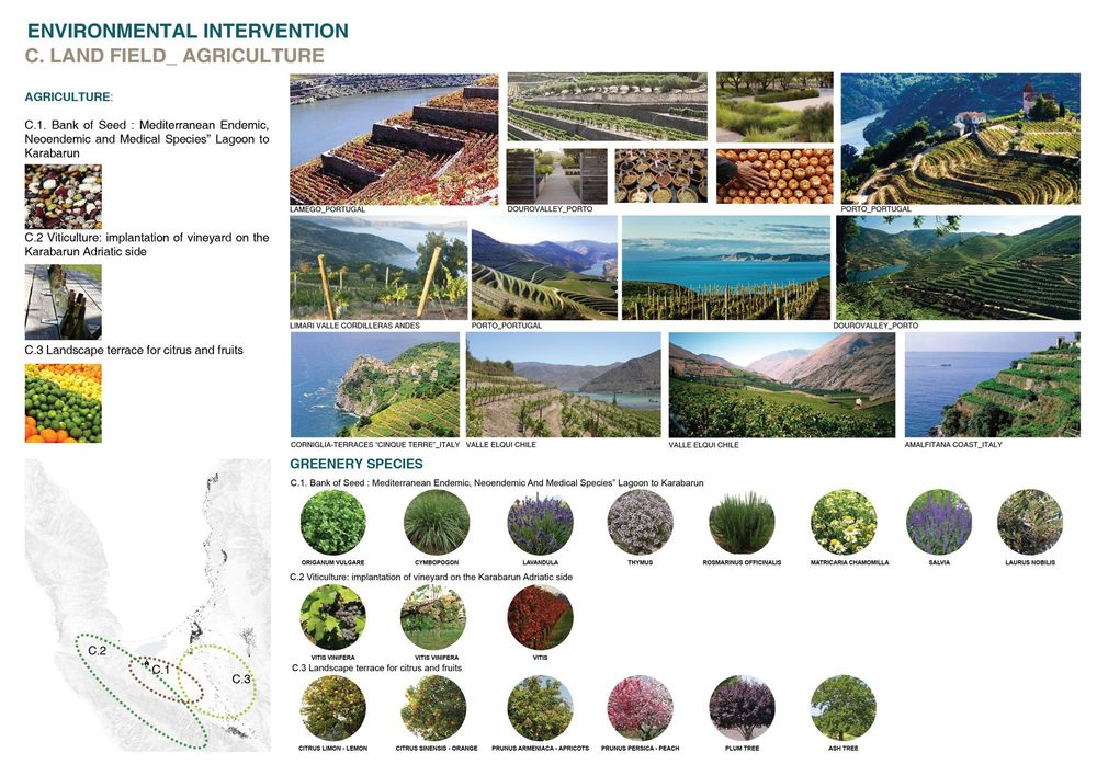
To give new impulse to local agriculture were identified three intervention strategies according to different areas of the region: for the agricultural area in the south of the lagoon the project proposed cultivation with medicinal plants and species with the establishment of a medical seed bank. Viticulture is particularly suited to the Adriatic front of Karaburun, while the inland hills are suitable for citrus cultivation.
[ITA] Il progetto consiste nel masterplan per lo sviluppo turistico e progettazione urbana e di spazi pubblici e servizi per l’area costiera e i villaggi limitrofi della Regione di Orikum. Il progetto istituisce il Parco Nazionale del Karaburun-Orikum lagoon-Llogara: con l’obiettivo d’istituire un Centro d’Eccellenza che possa offrire esperienze uniche e diversificate. Per raggiungere questo obiettivo è stato proposto un processo che promuova l’attrattività e l’accessibilità dell’area costiera di Orikum integrando valenze archeologiche, patrimonio marittimo, turismo balneare e marino, attività sportive e naturalistiche, promozione enogastronomiche etc
L’istituzione del National Park Llogara+Karaburun+Orikum Lagoon avviene attraverso la definizione di un perimetro chiaro delimitato da buffer zone ed includente anche l’area lagunare, la chiesa di Marmiru e l’area archeologiche. Il parco sarà dotato di un centro di accoglienza per i visitatori e da un sistema di attrezzature di supporto alle molteplici attività presenti (MFS Modular Furniture System). L’esistente strada costiera che interrompe il naturale collegamento tra la laguna ed il mare, viene arretrata e rilocalizzata alle spalle della laguna, al confine con i campi agricoli e si ricollega ai percorsi esistenti del Karaburun. La riserve del Karaburun, oggetto negli anni di diversi incendi, sarà interessata da un piano di riforestazione volto al miglioramento delle condizioni di fruizione dell’area. La riconoscibilità del nuovo parco viene supportata dalla creazione di un brand del parco: un logo, un nome (K.O.L per Karaburun-Orikum-Llogara) che segnerà tutti i percorsi ed i punti nodali dell’area.
Oltre alla valorizzazione delle valenze naturalistiche esistenti, il progetto propone l’individuazione di percorsi archeologici capaci di riconnettere Old Trajas e altri siti storici ed archeologi all’interno della rete di valenze della regione di Orikum. Il progetto propone inoltre la riconversione del borgo di Old Trajas in un hotel diffuso ed il restauro e conservazione degli edifici storici di Rradhima.
Per la fascia costiera settentrionale il progetto si concentra sul limitare l’espansione della città verso la fascia costiera (protetta da un vincolo di in edificabilità di 300m) e per la città di Orikum propone interventi mirati alla valorizzazione degli spazi pubblici urbani estremamente frammentati.
Per dare nuovo impulso all’agricoltura locale sono state individuate 3 strategie d’intervento diversificate a seconda delle aree della regione: per l’area agricola a sud della laguna si è proposta la coltivazione con piante officinali e specie medicali con l’istituzione di una banca del seme. La viticoltura è particolarmente adatta al fronte adriatico del Karaburun, mentre le colline più interne sono adatte alla coltivazione a terrazze degli agrumi.


